This article needs additional citations for verification .(October 2021) |
Wellpark is a suburb of Galway city, Ireland. The area is bordered by the N6 Dublin Road to the south, the Tuam Road to the West and the suburb of Mervue on the east.
This article needs additional citations for verification .(October 2021) |
Wellpark is a suburb of Galway city, Ireland. The area is bordered by the N6 Dublin Road to the south, the Tuam Road to the West and the suburb of Mervue on the east.
(Irish: Garrain Phairc An Uarain, meaning "the home of the well")[2][3] Wellpark is a Gaeltacht[2] suburb of Galway city, Ireland. The area is bordered by the N6 Dublin Road to the south, the Tuam Road to the West and the suburb of Mervue on the east. It is 3 km (2 mi) east of Galway city, on the R336. Wellpark is on the eastern side of the county's Gaeltacht (Irish-speaking district) and of the city region. It is a tourist centre with a scenic beach, harbour, and shore fishing.
The area is home to the Wellpark Retail Centre which is a shopping area which boasts outlets such as Peter Pan, Reid Furniture, Maplin, Sony Centre, Toy City, Atlantic Homecare, PC World, Eddie Rocket's, Carpet Right and the Eye Cinema. It also has underground car-parking, and is based behind the plush "g" Hotel. The broadcasting headquarters of i102-104FM radio are also based here.
The area is also home to numerous housing developments, and various employers in the Mervue Business Park and the Thermo King plant.
Wellpark is home to 1,509 people [1] based on the 2006 Census. It is a relatively small area sized 0.816 km². [1]

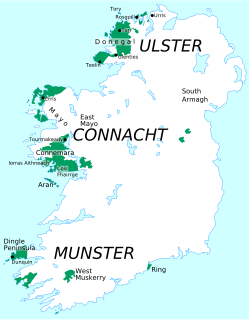
County Donegal is a county of Ireland in the province of Ulster. It is named after the town of Donegal in the south of the county. It has also been known as County Tyrconnell, after the historic territory of the same name, on which it was based. Donegal County Council is the local council and Lifford the county town.

Connacht, or Connaught, is one of the provinces of Ireland, in the west of Ireland. Until the ninth century it consisted of several independent major Gaelic kingdoms.

County Galway is a county in Ireland. It is in the West of Ireland, taking up the south of the province of Connacht.

Galway is a city in the West of Ireland, in the province of Connacht. It is the county town of County Galway, which is named after it. It lies on the River Corrib between Lough Corrib and Galway Bay, and is the sixth most populous city in the island of Ireland and the fourth most populous in the Republic of Ireland, with a population at the 2016 Census of 79,934.
Gaeltacht is an Irish term referring individually to any, or collectively to all, of the districts where the government recognises that the Irish language is the predominant vernacular, or language of the home.

The island of Ireland, comprising Northern Ireland and the Republic of Ireland, has an extensive network of tens of thousands of kilometres of public roads, usually surfaced. These roads have been developed and modernised over centuries, from trackways suitable only for walkers and horses, to surfaced roads including modern motorways. The major routes were established before Irish independence and consequently take little cognisance of the border other than a change of identification number and street furniture. Northern Ireland has had motorways since 1962, and has a well-developed network of primary, secondary and local routes. The Republic started work on its motorway network in the early 1980s; and historically, the road network there was once somewhat less well developed. However, the Celtic Tiger economic boom and an influx of European Union structural funding, saw national roads and regional roads in the Republic come up to international standard quite quickly. In the mid-1990s, for example, the Republic went from having only a few short sections of motorway to a network of motorways, dual carriageways and other improvements on most major routes as part of a National Development Plan. Road construction in Northern Ireland now tends to proceed at a slower pace than in the Republic, although a number of important bypasses and upgrades to dual carriageway have recently been completed or are about to begin.
National Development Plan was the title given by the Irish Government to a scheme of organised large-scale expenditure on (mainly) national infrastructure. The first five-year plan ran from 1988 to 1993, the second was a six-year plan from 1994 to 1999 and the third ran as a seven-year plan from 2000 to 2006. A fourth National Development Plan ran from 2007 to 2011. The main elements of the third plan were the development of a national motorway network between the major cities in Ireland. The upgrading of the rail network was a secondary scheme.

Tuam ( TEW-əm; Irish: Tuaim[ˈt̪ˠuəmʲ], meaning 'mound' or 'burial-place'}} is a town in Ireland and the second-largest settlement in County Galway. It is west of the midlands of Ireland, about 35 km north of Galway city. Humans have lived in the area since the Bronze Age while the historic period dates from the 6th century. The town became increasingly important in the 11th and 12th centuries in political and religious aspects of Ireland. The market-based layout of the town and square indicates the importance of commerce.
Tubbercurry or Tobercurry is the second-largest town in terms of both population and land area in County Sligo, Ireland. It lies at the foot of the Ox Mountains, on the N17 national primary road. The village is twinned with Viarmes in France. Tubbercurry achieved status as a Fairtrade town in September 2008.

Headford is a town in County Galway, located 26 km north of Galway city in the west of Ireland. It is an angling centre for the eastern shore of Lough Corrib, and Greenfields, approximately 6.5 km west of the town, is its boating harbour. The town is situated next to the Black River which is the county boundary with Mayo. Located on the N84 national secondary road from Galway to Castlebar and the R333, and R334 regional roads the town is a commuter town to Galway City.

Killala is a village in County Mayo in Ireland, north of Ballina. The railway line from Dublin to Ballina once extended to Killala. To the west of Killala is a Townsplots West, which contains a number of ancient forts.

The N17 road is a national primary road in Ireland, and is part of the Atlantic Corridor route. It begins in County Galway and ends in County Sligo. On 27 September 2017 the southern, Tuam–Galway, section was upgraded to motorway status and designated M17.

The N18 road is a national primary road in Ireland, connecting the cities of Limerick and Galway. Ennis and Gort are two major towns on the route, and Shannon Airport is reached via the connecting N19. The west coast route continues on to Sligo as the N17. The section from Limerick to the N19 junction forms part of European route E20, and the entire route is part of the proposed Atlantic Corridor. The section of motorway from Shannon to Claregalway is designated the M18 motorway. The tolled Limerick Tunnel forms part of the route.
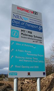
Transport 21 was an Irish infrastructure plan, announced in November 2005. Its aims were to greatly expand Ireland's transport network. A cost estimate of €34 billion was attached to the plan at the time.
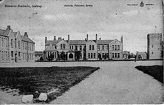
Renmore is a suburb of Galway City, Ireland, situated approximately 2 km to the east of the city. Renmore runs east along the coast and south of Dublin Road, from the shore of Lough Atalia on its west side to Lurgan Park on its east. The area houses approximately 5,000 people and includes Ballyloughane beach, which also has camping facilities.

Mervue United A.F.C. is an Irish association football club based in Mervue, Galway. Their senior men's team currently plays in the Galway & District League. The club has previously fielded teams in the Connacht Senior League, the League of Ireland U21 Division, the A Championship and the League of Ireland First Division.

The West Region is a NUTS Level III statistical region of Ireland. It consists of the territory of Galway City, the regional capital, as well as the counties of Galway, Mayo and Roscommon. The West region spans 13,801 km² and has a population of 453,109.

The Atlantic corridor or Atlantic motorway is a proposed road project in Ireland. The scheme, announced in 2005, was intended to link Waterford in the South-East to Letterkenny in the North-West via motorway or dual carriageway by 2015. However, in part due to the post-2008 Irish economic downturn, major sections of the roadway were delayed or cancelled.
Since the early 2000s, a number of proposals have been made by politicians and interest groups in Galway to introduce a light rail system in the city. No light rail proposal for the city has received any government support to date.

Clonlonan is a barony in south–west County Westmeath, Ireland. It was formed by 1672. It is bordered by County Offaly to the south and a small part of County Roscommon at Long Island on the River Shannon to the west. It also borders four other Westmeath baronies: Kilkenny West and Rathconrath, Moycashel and Brawny. The largest centre of population in the barony is the town of Moate.