Wanapum Dam is a run-of-the-river hydroelectric project located on the Columbia River downstream (south) from Vantage, Washington where Interstate 90 crosses the Columbia from Grant County into Kittitas County. It is owned by the Grant County Public Utility District. Its reservoir is named Lake Wanapum.

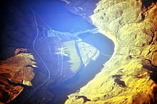
Priest Rapids Dam is a hydroelectric, concrete gravity dam; located on the Columbia River, between the Yakima Firing Range and the Hanford Nuclear Reservation, and bridges Yakima County and Grant County, in the U.S. state of Washington. The dam is 24 miles south of the town of Vantage, and 47 miles northwest of the city of Richland. It is located at mile marker 397.1 from the mouth of the Columbia. It is owned by the Grant County Public Utility District (PUD). Priest Rapids, for which the dam was named, are now submerged beneath the dam's reservoir.

Grand Coulee Dam is a concrete gravity dam on the Columbia River in the U.S. state of Washington, built to produce hydroelectric power and provide irrigation water. Constructed between 1933 and 1942, Grand Coulee originally had two powerhouses. The third powerhouse ("Nat"), completed in 1974 to increase energy production, makes Grand Coulee the largest power station in the United States by nameplate-capacity at 6,809 MW.

The Okanogan River is a tributary of the Columbia River, approximately 115 mi (185 km) long, in southern British Columbia and north central Washington. It drains a scenic plateau region called the Okanagan Country east of the Cascade Range and north and west of the Columbia, and also the Okanagan region of British Columbia. The Canadian portion of the river has been channelized since the mid-1950s.
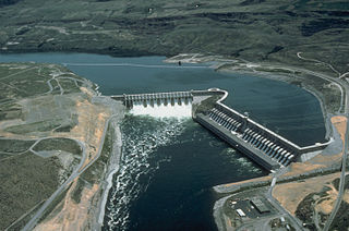
The Chief Joseph Dam is a concrete gravity dam on the Columbia River, 2.4 km (1.5 mi) upriver from Bridgeport, Washington. The dam is 877 km (545 mi) upriver from the mouth of the Columbia at Astoria, Oregon. It is operated by the USACE Chief Joseph Dam Project Office and the electricity is marketed by the Bonneville Power Administration.

The Colville Indian Reservation is an Indian reservation in the northwest United States, in north central Washington, inhabited and managed by the Confederated Tribes of the Colville Reservation, which is federally recognized.
The Confederated Tribes of the Colville Reservation is the federally recognized tribe that controls the Colville Indian Reservation, which is located in northeastern Washington, United States. It is the government for its people.

Franklin D. Roosevelt Lake is the reservoir created in 1941 by the impoundment of the Columbia River by the Grand Coulee Dam in Washington state. It is named for Franklin D. Roosevelt, who was president during the construction of the dam. Covering 125 square miles, it stretches about 150 miles (240 km) from the Canada–US border to Grand Coulee Dam, with over 600 miles (970 km) of shoreline; by surface area it is the largest lake and reservoir in Washington. It is the home of the Lake Roosevelt National Recreation Area.
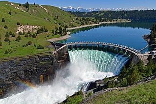
The Seli’š Ksanka Qlispe’ Dam previously known as the Kerr Dam is a concrete gravity-arch dam located at river mile 72 of the Flathead River. Built in 1938, it raises the level and increases the size of Flathead Lake near Polson, Montana. The dam was designed to generate hydroelectricity but also serves recreational and irrigation uses.
The Chelan County Public Utility District, or Chelan County PUD, provides electric, water, wastewater public utility and telecommunications services in Chelan County, in north-central Washington, USA.

Lake Roosevelt National Recreation Area is a U.S. national recreation area that encompasses the 130-mile (210 km) long Franklin D. Roosevelt Lake between Grand Coulee Dam and Northport, Washington, in eastern Washington state. The Grand Coulee Dam was built on the Columbia River in 1941 as part of the Columbia River Basin project. Lake Roosevelt National Recreation Area is a unit of the National Park Service and provides opportunities for fishing, swimming, canoeing, boating, hunting, camping, and visiting historic Fort Spokane and St. Paul's Mission. Crescent Bay Lake in Grant County just southwest of Lake Roosevelt also falls under the jurisdiction of the National Recreation Area.

The Methow River is a tributary of the Columbia River in northern Washington in the United States. The river's 1,890-square-mile (4,900 km2) watershed drains the eastern North Cascades, with a population of about 5,000 people. The Methow's watershed is characterized by relatively pristine habitats, as much of the river basin is located in national forests and wildernesses. Many tributaries drain the large Pasayten Wilderness. An earlier economy based on agriculture is giving way to one based on recreation and tourism.

Lake Chelan Dam officially known as the Lake Chelan Hydroelectric Project is located approximately 32 miles (51 km) north of the city of Wenatchee in Chelan County. The dam is located at the lower or southeasterly end of 50.4 miles long Lake Chelan, and is within the limits of the city of Chelan. The powerhouse is located near the community of Chelan Falls. The reservoir has 677,400 acre-feet (835,600,000 m3) of usable water storage. The 10-year average generation for the Project is 365,000 megawatt hours.

Condit Hydroelectric Project was a development on the White Salmon River in the U.S. state of Washington. It was completed in 1913 to provide electrical power for local industry, and is listed in the National Register of Historic Places as an engineering and architecture landmark.
The Colville people, are a Native American people of the Pacific Northwest. The name Colville comes from association with Fort Colville, named after Andrew Colvile of the Hudson's Bay Company. Okanagan: sx̌ʷyʔiɬpx) Earlier, outsiders often called them Scheulpi, Chualpay, or Swhy-ayl-puh; the French traders called them Les Chaudières in reference to Kettle Falls. The neighboring Coeur d'Alene called them Sqhwiyi̱'ɫpmsh and the Spokane knew them as Sxʷyelpetkʷ.
Hydroelectricity is, as of 2019, the second-largest renewable source of energy in both generation and nominal capacity in the United States. In 2021, hydroelectric power produced 31.5% of the total renewable electricity, and 6.3% of the total U.S. electricity.
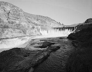
The Enloe Dam, also known as the Similkameen Dam, and its powerplant are located on the Similkameen River about 4 miles (6.4 km) west-northwest of Oroville, Washington. Located just above Similkameen (Coyote) Falls, the concrete arch-gravity dam stands about 54 feet (16 m) high, with a crest length of about 290 feet (88 m), built between 1916 and 1923. The dam was named after the president of the Okanogan Valley Power Company, Eugene Enloe. The dam was operated to generate power at its powerplant, located about 850 feet (260 m) downstream from the dam. Lacking fish ladders, Enloe Dam blocks fish passage and completely extirpated anadromous fish migration into the upper reaches of the Similkameen River and its tributaries in Canada.

Pelton Dam is a major dam on the Deschutes River in Jefferson County, Oregon, owned and operated as a hydroelectric facility by Portland General Electric, one element of its Pelton Round Butte Project on the Deschutes.