Werder (Havel)

Last updated
Werder (Havel)
Werder.jpg
City island in the River Havel, with
Großer Plessower See in the background
DEU Werder (Havel) COA.svg
Location of Werder (Havel) within Potsdam-Mittelmark district
Werder (Havel) in PM.pngBeetzseeGolzowRosenauSchwielowseeWollin
Germany adm location map.svg
Red pog.svg
Werder (Havel)
Brandenburg location map.svg
Red pog.svg
Werder (Havel)
Coordinates: 52°23′N12°56′E / 52.383°N 12.933°E / 52.383; 12.933
Country Germany
State Brandenburg
District Potsdam-Mittelmark
Subdivisions8 Ortsteile
Government
   Mayor (202230) Manuela Saß [1] (CDU)
Area
  Total115.99 km2 (44.78 sq mi)
Elevation
31 m (102 ft)
Population
 (2021-12-31) [2]
  Total26,767
  Density230/km2 (600/sq mi)
Time zone UTC+01:00 (CET)
  Summer (DST) UTC+02:00 (CEST)
Postal codes
14542
Dialling codes 03327
Vehicle registration PM
Website www.werder-havel.de

Werder (Havel) (official name derived from Werder an der Havel ("Werder upon Havel"), colloquially just Werder) is a town in the state of Brandenburg, Germany, located on the Havel river in the Potsdam-Mittelmark district, west of the state's capital Potsdam.

Contents

Werder has a long and rich history and is a nationally recognized Erholungsort – a government designation given to regions of Germany that have been recognized and must be continuously re-certified as having air and climate qualities which provide a healthful environment to visitors. Werder is also famous for hosting a Cherry Blossom Festival, the Baumblütenfest , every May.

Etymology

The Werder municipal area stretches along the banks of the Havel, a tributary of the Elbe, and the town's oldest quarter is located on an island in the river. Hence the name, as the landscape term Werder (like Wörth in Upper German) means "river island".

History

Werder has several different specific mentions in the ancient historical records of Berlin, which lies 40 km (25 mi) north east. The city "Werdere" is mentioned in 1317, "Wehrder" in 1450 and in its present spelling in 1580. However, in its southwest end pieces of ancient broken glass have been discovered, and on its south end are remains of what may have been an Early Medieval Slavic castle wall.

The coin-shaped city island in the Havel river is mentioned as being accessible via a bridge in a 1317 deed, when the ministeriales of the Brandenburg margraves had to sell the estates to the monks of nearby Lehnin Abbey. The town was devastated by Swedish troops during the Thirty Years' War.

During World War II and prior thereto an airfield existed in the north of the city which, together with an adjacent park, was used during the war as an airplane pilot training area. Werder was the base of Luftwaffe general Karl Koller during the Battle of Berlin. After the end of the war, Soviet troops were stationed in this area of the city. The last Russian troops departed in 1993, three years after the reunification of Germany.

Demography

Werder (Havel): Population development
within the current boundaries (2020) [3]
YearPop.±% p.a.
1875 9,271    
1890 11,415+1.40%
1910 12,925+0.62%
1925 14,342+0.70%
1939 19,699+2.29%
1950 20,469+0.35%
1964 18,250−0.82%
YearPop.±% p.a.
1971 18,017−0.18%
1981 18,069+0.03%
1985 18,159+0.12%
1990 17,838−0.36%
1995 19,404+1.70%
2000 22,218+2.75%
2005 22,874+0.58%
YearPop.±% p.a.
2010 23,017+0.12%
2015 24,856+1.55%
2016 25,345+1.97%
2017 25,695+1.38%
2018 26,184+1.90%
2019 26,412+0.87%
2020 26,662+0.95%

Politics

Since 1990, Werder's mayor has been Werner Große of the Christian Democratic Union (CDU), who had previously functioned as the city's deputy. The 29-seat town council (SVV), meets every two months, to represent the interests of the citizenry. The council is composed of 17 CDU members, 4 Social Democratic Party members, 3 Action Free Citizens members and various other unaffiliated city delegates.

There are a number of committees with appointed citizens delegates who consult with the town council. The central committee, which exists under chairmanship of the mayor, deals with finances in consultation with an auditing board of examiners. The committee for social policy, education, culture and sport, oversees area schools. There is also a special committee responsible for town development, construction and living conditions, which has significant influence over the city's infrastructure.

Economics

Although at one time known for its wine production and fishing industry, both pursuits declined during the 18th century. From early times, the monks of the Cistercian monastery of Lehnin cultivated fruit in the region, and Werder is still particularly well known for this endeavor, which is also the foundation for its famous blossoming season festival. The predominant fruits grown in the area are cherries, apples, and strawberries but raspberries, gooseberries, currants, blackberries, apricots, peaches, pears, and plums are also cultivated. Vegetables are also grown, especially tomatoes, the bulk of which are cultivated in local greenhouses.

Viticulture

Location of the wineyard in the town Lagekarte zum Grossen Plessower See.png
Location of the wineyard in the town

Wine cultivation is the city's second-oldest trade after fishing, brought to this area before 1300 by monks of the Cistercian Order. The wine of the Margraviate of Brandenburg (Mark Brandenburg) was by the end of the 13th century one the region's most important exports to eastern and northern Europe. The Hohenzollern dynasty that came from Franconia to Brandenburg, made the wine of the Brandenburg Mark part of its court. Until the death of the Great Elector, the wine was drunk in his residence. The first Wine Master Order of Brandenburg was founded in 1598 by the Elector Johann Georg, and at that time it was reported that Havel would also have vineyards just like the ones in the Moselle. However, the viticulture in this area was not trouble-free. The winters could be extremely hard on occasion, when many vines would get frostbite. This happened in the winter of 1739/40, when the frost lasted until June. In the first half of the 18th century, grapes were grown on more than 100 hectares in Werder. The vines at that time were Weißer Elbling, Weißer and Roter Schönedel, and Rotfranke grapes. Nevertheless, more red wine than white wine was grown. The Werderaner Wachtelberg (Quail's Mountain) is the oldest winegrowing location beyond the island of Werder. On the island, vineyards were located on the Muhlenberg hill. The vineyards existed before their envelopment by fruit trees, especially apricots and peaches. The fruits were transported with great care in the Obsttienen (small wooden transport containers).

In 1887 it was reported that 2 vineyards remained. Wine cultivation ended when the last vines in Werder were frostbitten in the winter of 1955/56. In 1985 the Fruit Production Cooperative of Werder was founded on the Werderaner Wachtelberg, with a vineyard covering 4.8 hectares. Today about 30,000 vines grow there on nearly 7 hectares of land. Dornfelder, Regent, Saphira, and Müller-Thurgau grapes are grown here, among other varieties. Within the scope of the Federal Garden Show (Bundesgartenschau) in Potsdam, Wine Teaching Paths were established at the Werderaner Wachtelberg. Today 38 red and 40 white wine varieties are grown here. The Werderaner Wachtelberg vineyard lies at a latitude of 52 degrees and 22 minutes north, far to the north of the typical winegrowing areas in Europe. In 1991 the vineyard was given Großlagenfreie Einzellage classification in the Weinanbaugebiet Saale-Unstrut (winegrowing area on the Saale and Unstrut rivers) and was also recognised by the EU. It is at the most northern registered position for quality-tested wine cultivation (QbA) in Europe and the world.

Notable people

International relations

Twin towns — Sister cities

Werder is twinned with:

See also

Related Research Articles

<span class="mw-page-title-main">Brandenburg an der Havel</span> Town in Brandenburg, Germany

Brandenburg an der Havel is a town in Brandenburg, Germany, which served as the capital of the Margraviate of Brandenburg until it was replaced by Berlin in 1417.

<span class="mw-page-title-main">Havelland (district)</span> District in Brandenburg, Germany

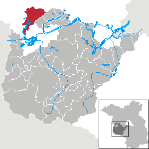
Havelland is a district or county in Brandenburg, Germany. It is bounded by the districts of Ostprignitz-Ruppin and Oberhavel, the city-state of Berlin, the district of Potsdam-Mittelmark, the city of Brandenburg and the state of Saxony-Anhalt.

<span class="mw-page-title-main">Potsdam-Mittelmark</span> District in Brandenburg, Germany

Potsdam-Mittelmark is a Kreis (district) in the western part of Brandenburg, Germany. Its neighbouring administrative units are the district of Havelland, the free cities of Brandenburg and Potsdam, the state of Berlin, the district of Teltow-Fläming, and the districts of Wittenberg, Anhalt-Bitterfeld and Jerichower Land in Saxony-Anhalt.

<span class="mw-page-title-main">Kloster Lehnin</span> Municipality in Brandenburg, Germany

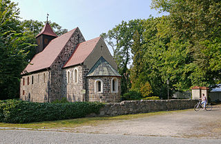
Kloster Lehnin, or just Lehnin, is a municipality in the German state of Brandenburg. It lies about 24 km (15 mi) west-south-west of Potsdam.

<span class="mw-page-title-main">Teltow</span> Town in Brandenburg, Germany

Teltow [German pronunciation:['tɛltoː] ] is a town in the Potsdam-Mittelmark district, in Brandenburg, Germany.

<span class="mw-page-title-main">Stahnsdorf</span> Municipality in Brandenburg, Germany

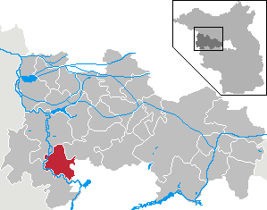
Stahnsdorf is a municipality in the Potsdam-Mittelmark district, in Brandenburg, Germany.

<span class="mw-page-title-main">Havelsee</span> Town in Brandenburg, Germany

Havelsee is a town in the Potsdam-Mittelmark district, in Brandenburg, Germany. It is situated on the river Havel, 12 km northwest of Brandenburg.

<span class="mw-page-title-main">Ketzin</span> Town in The Havelland Located in Brandenburg Germany

Ketzin is a town in the Havelland district, in Brandenburg, Germany. It is situated on the river Havel, 17 km northwest of Potsdam, and 40 km west of Berlin.

<span class="mw-page-title-main">Premnitz</span> Town in Brandenburg, Germany

Premnitz is a town in the Havelland district, in Brandenburg, Germany. It is situated on the river Havel, 8 km south of Rathenow, 21 km northwest of Brandenburg, and is only 75 km west of central Berlin, to where it is well connected by the railway and road networks. The surrounding landscape is very rural and forested in its make up.

<span class="mw-page-title-main">Groß Kreutz</span> Municipality in Brandenburg, Germany

Groß Kreutz is a municipality in the Potsdam-Mittelmark district, in Brandenburg, Germany.

<span class="mw-page-title-main">Michendorf</span> Municipality in Brandenburg, Germany

Michendorf is a municipality in the Potsdam-Mittelmark district, in Brandenburg, Germany.

<span class="mw-page-title-main">Nuthetal</span> Municipality in Brandenburg, Germany

Nuthetal is a municipality in the Potsdam-Mittelmark district, in Brandenburg, Germany.

<span class="mw-page-title-main">Schwielowsee (municipality)</span> Municipality in Brandenburg, Germany

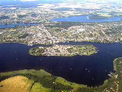
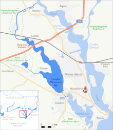
Schwielowsee is a municipality in the Potsdam-Mittelmark district, in Brandenburg, Germany. It is situated on the shore of the Schwielowsee lake, through which the River Havel flows. The municipality was founded on December 31, 2002 in merger of the three villages Caputh, Geltow and Ferch. The Caputh Ferry, a cable ferry across the Havel, links Caputh and Geltow. In the east Schwielowsee shares border with the City of Potsdam, in the west with the town of Werder (Havel).

<span class="mw-page-title-main">Tiene (container)</span> Container for transporting wine and fruit in Germany

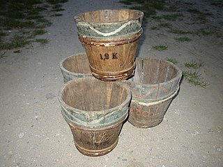
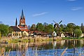
A Tiene, sometimes also called Tine or Obsttiene, was a special container for transporting wine and fruit. These were used until shortly after the First World War, mostly in the Brandenburg city of Werder in northern Germany. Normally the wooden tubs were carried on people's backs to small boats and shipped on the Havel River to market stalls in Berlin.

<span class="mw-page-title-main">Werderaner Wachtelberg</span> Vineyard in Brandenburg, Germany

The Werderaner Wachtelberg is a 6.2 hectares vineyard in the town of Werder (Havel) in Brandenburg. As the northernmost outpost of the Saale-Unstrut wine region, it is the most northern registered location for QbA quality wine in Germany.

<span class="mw-page-title-main">Berlin–Magdeburg railway</span>

The first section of the Berlin–Magdeburg Railway was opened in 1838 as the Berlin-Potsdam Railway and was the first railway line in Prussia. In 1846 it was extended to Magdeburg.

<span class="mw-page-title-main">Berlin/Brandenburg Metropolitan Region</span> Place in Germany

The Berlin/Brandenburg metropolitan region or capital region is one of eleven metropolitan regions of Germany, consisting of the entire territories of the state of Berlin and the surrounding state of Brandenburg. The region covers an area of 30,545 square kilometres (11,793 sq mi) with a total population of about 6.2 million.

<span class="mw-page-title-main">Brandenburg an der Havel – Potsdam-Mittelmark I – Havelland III – Teltow-Fläming I</span> Federal electoral district of Germany

Brandenburg an der Havel – Potsdam-Mittelmark I – Havelland III – Teltow-Fläming I is an electoral constituency represented in the Bundestag. It elects one member via first-past-the-post voting. Under the current constituency numbering system, it is designated as constituency 60. It is located in western Brandenburg, comprising the city of Brandenburg an der Havel, most of the Potsdam-Mittelmark district, and parts of the Havelland and Teltow-Fläming districts.

<span class="mw-page-title-main">Havelland</span> Region in Brandenburg, Germany

Geographically, the Havelland is the region around which the River Havel flows in a U-shape between Oranienburg to the northeast and Rhinow to the northwest. The northern boundary of the Havelland is formed by the River Rhin and the Rhin Canal. In the history of Brandenburg, the Havelland represents a historic region.

<span class="mw-page-title-main">Potsdam – Potsdam-Mittelmark II – Teltow-Fläming II</span> Federal electoral district of Germany

Potsdam – Potsdam-Mittelmark II – Teltow-Fläming II is an electoral constituency represented in the Bundestag. It elects one member via first-past-the-post voting. Under the current constituency numbering system, it is designated as constituency 61. It is located in western Brandenburg, comprising the city of Potsdam and small parts of the Potsdam-Mittelmark and Teltow-Fläming districts.

References

  1. Landkreis Potsdam-Mittelmark Wahl der Bürgermeisterin / des Bürgermeisters, accessed 13 November 2022.
  2. "Bevölkerungsentwicklung und Flächen der kreisfreien Städte, Landkreise und Gemeinden im Land Brandenburg 2021" (PDF). Amt für Statistik Berlin-Brandenburg (in German). June 2022.
  3. Detailed data sources are to be found in the Wikimedia Commons.Population Projection Brandenburg at Wikimedia Commons

Commons-logo.svg Media related to Werder (Havel) at Wikimedia Commons