West Alexandria, Ohio

Last updated

West Alexandria, Ohio
West Alexandria, Ohio (2021).jpg
West Alexandria, 2021
OHMap-doton-West Alexandria.png
Location of West Alexandria, Ohio
Map of Preble County Ohio Highlighting West Alexandria Village.png
Location of West Alexandria in Preble County
Coordinates: 39°44′50″N84°32′11″W / 39.74722°N 84.53639°W / 39.74722; -84.53639
Country United States
State Ohio
County Preble
Government
   Mayor Jeff Hickey[ citation needed ]
Area
[1]
  Total0.86 sq mi (2.24 km2)
  Land0.86 sq mi (2.24 km2)
  Water0.00 sq mi (0.00 km2)
Elevation
[2]
896 ft (273 m)
Population
 (2020)
  Total1,334
  Density1,545.77/sq mi (596.73/km2)
Time zone UTC-5 (Eastern (EST))
  Summer (DST) UTC-4 (EDT)
ZIP code
45381
Area code(s) 937, 326
FIPS code 39-82880
GNIS feature ID2400126 [2]
Website http://www.walexpreb.org/

West Alexandria is a village in Preble County, Ohio, United States. The population was 1,334 at the 2020 census.

Contents

History

West Alexandria was laid out in 1818. [3] The community derives its name from one of its founders, William Alexander. [4] A post office has been in operation at West Alexandria since 1828. [5]

Three buildings in the village have been listed on the National Register of Historic Places: the George B. Unger House, the Lange Hotel, and the West Alexandria Depot. [6]

Geography

According to the United States Census Bureau, the village has a total area of 0.67 square miles (1.74 km2), all land. [7]

Demographics

Historical population
CensusPop.Note
1870 455
1880 79674.9%
1890 575−27.8%
1900 74028.7%
1910 1,08045.9%
1920 994−8.0%
1930 924−7.0%
1940 9937.5%
1950 1,18319.1%
1960 1,52428.8%
1970 1,5531.9%
1980 1,313−15.5%
1990 1,46011.2%
2000 1,395−4.5%
2010 1,340−3.9%
2020 1,334−0.4%
U.S. Decennial Census [8]

2010 census

As of the census [9] of 2010, there were 1,340 people, 551 households, and 371 families living in the village. The population density was 2,000.0 inhabitants per square mile (772.2/km2). There were 611 housing units at an average density of 911.9 per square mile (352.1/km2). The racial makeup of the village was 96.4% White, 1.0% African American, 0.1% Native American, 0.6% Asian, 0.1% from other races, and 1.8% from two or more races. Hispanic or Latino of any race were 1.4% of the population.

There were 551 households, of which 35.0% had children under the age of 18 living with them, 46.5% were married couples living together, 16.5% had a female householder with no husband present, 4.4% had a male householder with no wife present, and 32.7% were non-families. 28.9% of all households were made up of individuals, and 12% had someone living alone who was 65 years of age or older. The average household size was 2.43 and the average family size was 2.96.

The median age in the village was 37.8 years. 25.4% of residents were under the age of 18; 8.9% were between the ages of 18 and 24; 25.8% were from 25 to 44; 25.1% were from 45 to 64; and 14.8% were 65 years of age or older. The gender makeup of the village was 47.7% male and 52.3% female.

2000 census

As of the census [10] of 2000, there were 1,395 people, 576 households, and 387 families living in the village. The population density was 1,929.0 inhabitants per square mile (744.8/km2). There were 600 housing units at an average density of 829.7 per square mile (320.3/km2). The racial makeup of the village was 99.07% White, 0.36% African American, 0.14% Native American, 0.14% from other races, and 0.29% from two or more races. Hispanic or Latino of any race were 0.57% of the population.

There were 576 households, out of which 32.3% had children under the age of 18 living with them, 52.1% were married couples living together, 10.6% had a female householder with no husband present, and 32.8% were non-families. 29.7% of all households were made up of individuals, and 13.5% had someone living alone who was 65 years of age or older. The average household size was 2.42 and the average family size was 3.03.

In the village, the population was spread out, with 25.9% under the age of 18, 8.3% from 18 to 24, 30.0% from 25 to 44, 20.4% from 45 to 64, and 15.3% who were 65 years of age or older. The median age was 36 years. For every 100 females there were 98.4 males. For every 100 females age 18 and over, there were 94.0 males.

The median income for a household in the village was $36,399, and the median income for a family was $41,685. Males had a median income of $30,982 versus $24,265 for females. The per capita income for the village was $17,628. About 5.4% of families and 7.4% of the population were below the poverty line, including 9.3% of those under age 18 and 8.8% of those age 65 or over.

West Alexandria Depot West Alexandria Depot.jpg
West Alexandria Depot
George B. Unger House, a historic site in the village George B. Unger House.jpg
George B. Unger House, a historic site in the village

Arts and culture

The village hosts an Oktoberfest and Peace Park, which includes music, food, crafts, and an antique car show. The village also hosts a Santa's Villa in December at Peace Park.[ citation needed ]

Education

Twin Valley Community Schools operates one elementary school, one middle school, and Twin Valley South High School. [11]

West Alexandria has a public library, a branch of the Preble County District Library. [12]

Notable people

See also

Related Research Articles

<span class="mw-page-title-main">Alexandria, Indiana</span> City in Indiana, United States

Alexandria is a city in Monroe Township, Madison County, Indiana, United States. It is about 48 miles (77 km) northeast of Indianapolis. According to the 2020 census, its population was 5,149, nearly unchanged from 2010.

<span class="mw-page-title-main">Preble County, Ohio</span> County in Ohio, United States

Preble County is a county located in the U.S. state of Ohio. As of the 2020 census, the population was 40,999, down 3.0% from the 2010 census population of 42,270. Its county seat is Eaton. The county was formed on February 15, 1808, from portions of Butler and Montgomery Counties. It is named for Edward Preble, a naval officer who fought in the American Revolutionary War and against the Barbary Pirates.

<span class="mw-page-title-main">Alexandria, Missouri</span> City in Missouri, United States

Alexandria is a city in eastern Clark County, Missouri, United States. As of the 2020 census, its population was 105.

<span class="mw-page-title-main">Preble, New York</span> Town in New York, United States

Preble is a town in Cortland County, New York, United States. The population was 1,357 at the 2020 census, down from 1,393 at the 2010 census. The town is named after Commodore Edward Preble, a naval hero.

<span class="mw-page-title-main">West Union, Ohio</span> Village in Ohio, United States

West Union is a village in Adams County, Ohio, United States, about 55 miles (89 km) southeast of Cincinnati. The population was 3,004 at the 2020 census. It is the county seat of Adams County. West Union is served by West Union High School, the Adams County/Ohio Valley School District, and the West Union Public Library, a branch of the Adams County Public Library.

<span class="mw-page-title-main">Riverlea, Ohio</span> Village in Ohio, United States

Riverlea is a village in Franklin County, Ohio, United States, surrounded by Worthington on its north, south, and east sides, and bordered on the west by the Olentangy River, across which is Columbus. Riverlea was incorporated in 1939, a small community that formed on former farmland. The population was 599 at the 2020 census.

<span class="mw-page-title-main">Cleves, Ohio</span> City in Ohio, United States

Cleves is a village in Miami Township, Hamilton County, Ohio, United States. Located along the Ohio River, it is a western suburb of Cincinnati. The population was 3,414 at the 2020 census.

<span class="mw-page-title-main">Wintersville, Ohio</span> Village in Ohio, United States

Wintersville is a village in central Jefferson County, Ohio, United States. The population was 3,609 as of the 2020 Census. It is part of the Weirton–Steubenville metropolitan area. The village is suburban in nature and is governed by a mayor and council elected by non-partisan ballot.

<span class="mw-page-title-main">Alexandria, Ohio</span> Village in Ohio, United States

Alexandria is a village in Licking County, Ohio, United States. The population was 483 at the 2020 census.

<span class="mw-page-title-main">Camden, Ohio</span> Village in Ohio, United States

Camden is a village in Preble County, Ohio, United States. The population was 1,989 at the 2020 census.

<span class="mw-page-title-main">Eaton, Ohio</span> City in Ohio, United States

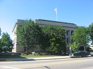
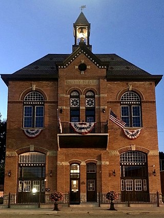
Eaton is a city in, and the county seat of Preble County, Ohio, United States, approximately 24 mi (38 km) west of Dayton. The population was 8,375 at the 2020 census, down 0.4% from the population of 8,407 at the 2010 census.

<span class="mw-page-title-main">Eldorado, Ohio</span> Village in Ohio, United States

Eldorado is a village in Preble County, Ohio, United States. The population was 458 at the 2020 census. It is part of the Dayton Metropolitan Statistical Area.

<span class="mw-page-title-main">Gratis, Ohio</span> Village in Ohio, United States

Gratis is a village in Preble County, Ohio, United States. The population was 842 at the 2020 census. It is part of the Dayton Metropolitan Statistical Area.

<span class="mw-page-title-main">Lewisburg, Ohio</span> Village in Ohio, United States

Lewisburg is a village in Preble County, Ohio, United States, founded in 1818. The current village incorporates two prior villages, the original Lewisburg and Euphemia, which merged in 1916. The population was 1,745 at the 2020 census. It is part of the Dayton Metropolitan Statistical Area.

<span class="mw-page-title-main">New Paris, Ohio</span> Village in Ohio, United States

New Paris is a village in Preble County, Ohio, United States. The population was 1,494 at the 2020 census. It is part of the Dayton Metropolitan Statistical Area.

<span class="mw-page-title-main">West Elkton, Ohio</span> Village in Ohio, United States

West Elkton is a village in Preble County, Ohio, United States. The population was 164 at the 2020 census. It is part of the Dayton Metropolitan Statistical Area.

<span class="mw-page-title-main">West Manchester, Ohio</span> Village in Ohio, United States

West Manchester is a village in Preble County, Ohio, United States. The population was 415 at the 2020 census. It is part of the Dayton Metropolitan Statistical Area.

<span class="mw-page-title-main">Bethlehem, West Virginia</span> Village in West Virginia, United States

Bethlehem is a village in Ohio County, West Virginia, United States. It is part of the Wheeling, West Virginia Metropolitan Statistical Area. The population was 2,499 at the 2010 census.

<span class="mw-page-title-main">College Corner, Ohio</span> Village in Ohio, United States

College Corner is a village in Butler and Preble counties in the southwestern part of the U.S. state of Ohio, 5 miles (8 km) northwest of Oxford. The population was 387 at the 2020 census. The village lies on the state line with Indiana, where it borders the town of West College Corner. The public school, part of the Union County–College Corner Joint School District, is bisected by the state line and is operated jointly with Indiana authorities.

<span class="mw-page-title-main">Verona, Ohio</span> Village in Ohio, United States

Verona is a village in Montgomery and Preble counties in the U.S. state of Ohio. The population was 403 at the 2020 census. It is part of the Dayton Metropolitan Statistical Area.

References

  1. "ArcGIS REST Services Directory". United States Census Bureau. Retrieved September 20, 2022.
  2. 1 2 U.S. Geological Survey Geographic Names Information System: West Alexandria, Ohio
  3. Lowry, Robert Eaton (1915). History of Preble County, Ohio: Her People, Industries and Institutions. B.F. Bowen. p. 162.
  4. Overman, William Daniel (1958). Ohio Town Names. Akron, OH: Atlantic Press. p. 140.
  5. "Preble County". Jim Forte Postal History. Retrieved December 18, 2015.
  6. "National Register Information System". National Register of Historic Places . National Park Service. July 9, 2010.
  7. "US Gazetteer files 2010". United States Census Bureau . Retrieved January 6, 2013.
  8. "Census of Population and Housing". Census.gov. Retrieved June 4, 2015.
  9. "U.S. Census website". United States Census Bureau . Retrieved January 6, 2013.
  10. "U.S. Census website". United States Census Bureau . Retrieved January 31, 2008.
  11. "Homepage". Twin Valley Community Schools. Retrieved March 3, 2018.
  12. "Locations". Preble County District Library. Retrieved March 3, 2018.