The John F. Kennedy Expressway is a nearly 18-mile-long (29 km) freeway in Chicago, Illinois, United States. Portions of the freeway carry I-190, I-90 and I-94. The freeway runs in a southeast–northwest direction between the central city neighborhood of the West Loop and O'Hare International Airport. The highway was named in commemoration of 35th US President John F. Kennedy. It conforms to the Chicago-area term of using the word expressway for an Interstate Highway without tolls. The Kennedy's official endpoints are the Jane Byrne Interchange with Interstate 290 and the Dan Ryan Expressway at the east end, and the O'Hare Airport terminals at the west end. I-190 runs from the western terminus at O'Hare Airport for 3.07 miles (4.94 km), where it meets I-90 and runs a further 6.29 miles (10.12 km), before joining with I-94 for the final 8.44 miles (13.58 km).

U.S. Route 76 is an east–west U.S. highway in the Southeastern United States that travels for 548 miles (882 km). Its western terminus is at US 41 and the eastern terminus of US 72 in the city of Chattanooga, Tennessee, where it travels in a generally due east direction, to its eastern terminus at Wrightsville Beach, North Carolina. It travels through the cities of Chattanooga, Tennessee, Ringgold, Georgia, Columbia and Florence, South Carolina, and Wilmington, North Carolina.

U.S. Highway 178 is a spur of U.S. Highway 78. It currently runs for 240.49 miles (387.03 km) from Dorchester, South Carolina, at U.S. Highway 78 to Rosman, North Carolina, at U.S. Highway 64. It passes through the states of South Carolina and North Carolina. It goes through the cities of Pickens, Anderson, North, Orangeburg, Harleyville, South Carolina and Bowman, South Carolina.

A partial cloverleaf interchange or parclo is a modification of a cloverleaf interchange.

Maryland Route 100 is a major east–west highway connecting U.S. Route 29 in Ellicott City and MD 177 in Pasadena. MD 100 also connects to Interstate 95 (I-95), US 1, the Baltimore–Washington Parkway, and I-97. The highway connects Howard County to the west with Anne Arundel County and the Chesapeake Bay to the east. MD 100 also provides access to the Baltimore–Washington International Airport (BWI) and the Arundel Mills shopping mall.

Coral Way, co-signed State Road 972 between Douglas Road and US 1 in Miami, is a 16.4-mile-long (26.4 km) primary east-west street that extends from Southwest 157th Avenue in western Miami-Dade County to Brickell Avenue in the Brickell neighborhood of Downtown Miami, Florida.

Red Road, also known as West 57th Avenue, is a 20.6-mile (33.2 km) main north-south street running west of downtown Miami in Miami-Dade County, Florida and into Broward County. Red Road is signed as State Road 959 from U.S. 1 to the south end of the Miami International Airport, and State Road 823 from U.S. 27 to the Broward County line.

Redland,</ref> is a historic unincorporated community and agricultural area in Miami-Dade County, Florida, located about 20 miles (32 km) southwest of downtown Miami and just northwest of Homestead, Florida. It is unique in that it constitutes a large farming belt directly adjoining what is now the seventh most populous major metropolitan area in the United States. Named for the pockets of red clay that cover a layer of oolitic limestone, Redland produces a variety of tropical fruits, many of which do not grow elsewhere in the continental United States. The area also contains a large concentration of ornamental nurseries. The landscape is dotted with u-pick'em fields, coral rock (oolite) walls, and the original clapboard homes of early settlers and other historic early twentieth century structures.

Macleod Trail is a major road in Calgary, Alberta. It is a six- to eight-lane principal arterial road extending from downtown Calgary to the south of the city, where it merges into Highway 2. South of Anderson Road, Macleod Trail is an expressway and is slated to be upgraded to a freeway in the future. It is named for its destination to the south, Fort Macleod.

Broomhill is an affluent, middle class area of Aberdeen, Scotland. It is situated in the west end and is accessible by the A92 road. The area is home to a primary school, Broomhill.
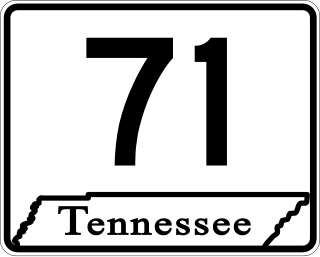
State Route 71 is a north–south state highway in Tennessee. For most of the length it is a "hidden" route, as it coincides with US 441 in all but a short section in Knoxville. The road begins at the North Carolina state line in Sevier County within the Great Smoky Mountains National Park at Newfound Gap and ends at an intersection with US 25W, SR 116, and SR 9 (hidden) in Rocky Top. Along its length SR 71 passes through Sevier County, a small portion of Blount County, Knox County, Anderson County, and in and out of Campbell County. Despite being signed on Hall of Fame Parkway in Knoxville, Tennessee, the Knox County TDOT map ignores SR 71 while SR 33 has a concurrency with US 441.

Whitemud Drive is a major east–west freeway in southern Edmonton, Alberta, that stretches from 231 Street at the western city limit to Anthony Henday Drive just east of Edmonton in Strathcona County. The portion in southeast Edmonton from Anthony Henday Drive to Calgary Trail / Gateway Boulevard is designated as Highway 14, and from there until Anthony Henday Drive in west Edmonton is designated as Highway 2. The portion of Whitemud Drive from 170 Street and 75 Street forms part of the Edmonton inner ring road.

The 1984 Denver Broncos season was the franchise's 15th season in the National Football League (NFL), and the 25th overall. The team finished with its then franchise-best record of thirteen wins and three losses and were champions of the AFC West. In the playoffs, the Broncos were upset by the Pittsburgh Steelers in the Divisional Round, 24–17. This would be the final season for Tight End coach Fran Polsfoot, who died in April 1985.

The Detroit metropolitan area in southeast Michigan is served by a comprehensive network of roads and highways. Three primary Interstate Highways pass through the region, along with three auxiliary Interstates, and multiple state and U.S. Highways. These are supplemented by the Mile Road System, a series of local roads spaced one mile apart on a perpendicular grid.

South Dunedin is a major inner city suburb of the New Zealand city of Dunedin. It is located, as its name suggests, 2.5 kilometres (1.6 mi) to the south of the city centre, on part of a large plain known locally simply as "The Flat". The suburb is a mix of industrial, retail, and predominantly lower-quality residential properties.

Soldiers Field Road is a major crosstown parkway in Boston, Massachusetts, running west to east from U.S. Route 20 in the northwest corner of Brighton to the Boston University Bridge. It follows the course of the Charles River and also passes by the campuses of Harvard University and Boston University. The road is named for the area south of the road on a bend in the Charles River. On June 5, 1890, Henry Lee Higginson presented Harvard College a gift of 31 acres of land, which he called Soldiers Field, given in honor of his friends who died in the Civil War: James Savage, Jr., Charles Russell Lowell, Edward Barry Dalton, Stephen George Perkins, James Jackson Lowell, and Robert Gould Shaw. This land later became the home of Harvard Crimson athletics.
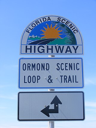
The Ormond Scenic Loop and Trail is a series of scenic state and county highways in Volusia County, Florida. CR 2002 is the northern leg of the trail. CR 4011(Old Dixie Highway and North Beach Street) is the western leg, with a spur onto Pine Tree Drive. SR 40(East Granada Boulevard) is the southern leg of the trail. CR 2803(John Anderson Drive) is the central leg of the trail, and SR A1A is the eastern leg of the trail. Florida Scenic Highway, designated this route on July 9, 2007.

14 Street W is the name of two major arterial roads and a short collector road in Calgary, Alberta, separated by the Elbow River and the West Nose Creek valley. Originally proposed as a continuous route and north-south freeway, the plans were cancelled in favor of 24 Street W, which became Crowchild Trail.
The M31 is a metropolitan route in Johannesburg, South Africa. The road connects the southern suburbs of Alberton with Johannesburg's northern suburbs. The routes eastern bypass in the Johnannesburg CBD connects the M2 motorway at the Heidelberg Interchange with M1 North motorway in Houghton and then the route follows the M1 motorway northwards until the M31 ends in Bramley.