
The South Platte River is one of the two principal tributaries of the Platte River. Flowing through the U.S. states of Colorado and Nebraska, it is itself a major river of the American Midwest and the American Southwest/Mountain West. Its drainage basin includes much of the eastern flank of the Rocky Mountains in Colorado; much of the populated region known as the Colorado Front Range and Eastern Plains; and a portion of southeastern Wyoming in the vicinity of the city of Cheyenne. It joins the North Platte River in western Nebraska to form the Platte, which then flows across Nebraska to the Missouri. The river serves as the principal source of water for eastern Colorado. In its valley along the foothills in Colorado, it has permitted agriculture in an area of the Colorado Piedmont and Great Plains that is otherwise arid.

The Little Colorado River is a tributary of the Colorado River in the U.S. state of Arizona, providing the principal drainage from the Painted Desert region. Together with its major tributary, the Puerco River, it drains an area of about 26,500 square miles (69,000 km2) in eastern Arizona and western New Mexico. Although it stretches almost 340 miles (550 km), only the headwaters and the lowermost reaches flow year-round. Between St. Johns and Cameron, most of the river is a wide, braided wash, only containing water after heavy snowmelt or flash flooding.
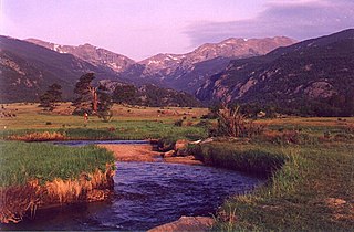
The Big Thompson River is a tributary of the South Platte River, approximately 78 miles (123 km) long, in the U.S. state of Colorado.

Roaring Fork River is a tributary of the Colorado River, approximately 70 miles (110 km) long, in west central Colorado in the United States. The river drains a populated and economically vital area of the Colorado Western Slope called the Roaring Fork Valley or Roaring Fork Watershed, which includes the resort city of Aspen and the resorts of Aspen/Snowmass.

The Clark Fork, or the Clark Fork of the Columbia River, is a river in the U.S. states of Montana and Idaho, approximately 310 miles (500 km) long. The largest river by volume in Montana, it drains an extensive region of the Rocky Mountains in western Montana and northern Idaho in the watershed of the Columbia River. The river flows northwest through a long valley at the base of the Cabinet Mountains and empties into Lake Pend Oreille in the Idaho Panhandle. The Pend Oreille River in Idaho, Washington, and British Columbia, Canada which drains the lake to the Columbia in Washington, is sometimes included as part of the Clark Fork, giving it a total length of 479 miles (771 km), with a drainage area of 25,820 square miles (66,900 km2). In its upper 20 miles (32 km) in Montana near Butte, it is known as Silver Bow Creek. Interstate 90 follows much of the upper course of the river from Butte to northwest of Missoula. The highest point within the river's watershed is Mount Evans at 10,641 feet (3,243 m) in Deer Lodge County, Montana along the Continental Divide.

Rowe Glacier is an alpine glacier in Rocky Mountain National Park in the U.S. state of Colorado. Rowe Glacier is 300 yd (270 m) north of Hagues Peak and is the source of the North Fork Big Thompson River. Rowe Glacier was the first glacier to be identified in Colorado.
North Fork Little Thompson River is a tributary of the Little Thompson River in Larimer County, Colorado. It flows southeast from a source in Roosevelt National Forest to a confluence with the Little Thompson.

