Havre is the county seat and largest city in Hill County, Montana, United States. Havre is nicknamed the crown jewel of the Hi-Line. It is said to be named after the city of Le Havre in France. As of the 2020 census the population was 9,362.

The Great Northern Railway was an American Class I railroad. Running from Saint Paul, Minnesota, to Seattle, Washington, it was the creation of 19th-century railroad entrepreneur James J. Hill and was developed from the Saint Paul & Pacific Railroad. The Great Northern's route was the northernmost transcontinental railroad route in the U.S.

Glacier National Park is an American national park located in northwestern Montana, on the Canada–United States border, adjacent to Waterton Lakes National Park in Canada—the two parks are known as the Waterton-Glacier International Peace Park. The park encompasses more than 1 million acres (4,000 km2) and includes parts of two mountain ranges, more than 130 named lakes, more than 1,000 different species of plants, and hundreds of species of animals. This vast pristine ecosystem is the centerpiece of what has been referred to as the "Crown of the Continent Ecosystem," a region of protected land encompassing 16,000 sq mi (41,000 km2).

The Lake McDonald Lodge is a historic lodge located within Glacier National Park, on the southeast shore of Lake McDonald. The lodge is a 3+1⁄2-story structure built in 1913 based on Kirtland Cutter's design. The foundation and first floor walls are built of stone, with a wood-frame superstructure. The lobby is a large, open space that extends to the third story. It has a massive fireplace and a concrete floor scored in a flagstone pattern, with messages in several Indian languages inscribed into it. The rustic lodge was designated a National Historic Landmark in 1987 as one of the nation's finest examples of large-scale Swiss chalet architecture. Lake McDonald Lodge is a member of Historic Hotels of America, the official program of the National Trust for Historic Preservation.

Granite Park Chalet is located in the heart of Glacier National Park in the U.S. state of Montana at an elevation of 6,693 feet above sea level. The chalet was built in 1914 by the Great Northern Railway and is a National Historic Landmark contributing property, being one of five structures in the Great Northern Railway Buildings district. From Logan Pass along the Going-to-the-Sun Road, the chalet is a moderate 7.6 miles (12.2 km) hike along the famed Crown of the Continent Highline Trail, usually referred to simply as the Highline Trail. Much of the trail passes through the scenic Garden Wall section of the park, immediately west and parallel to the Continental Divide. The chalet is also accessible via the Loop Trail and the Swiftcurrent Trail. The trails are for hikers and horseback riders only; no vehicle access is provided. Granite Park Chalet is a limited services facility and those that spend the night make use of the full service kitchen to cook their own meals.

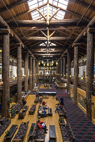
Many Glacier Hotel is a historic hotel located on the east shore of Swiftcurrent Lake in Glacier National Park in the U.S. state of Montana. The building is designed as a series of chalets, up to four stories tall, and stretches for a substantial distance along the lakeshore. The building has a Swiss alpine theme both on the outside and on the inside. The foundation is made of stone, with a wood superstructure. The outside is finished with brown-painted wood siding, and the window framing and balconies have wood sawed in Swiss jigsawed patterns. On the inside, the four-story lobby is surrounded by balconies, whose railings are patterned after Swiss designs.

Sperry Chalet is located about seven miles east of Lake McDonald in Glacier National Park in the U.S. state of Montana. The chalet was opened in 1914 by the Great Northern Railway and was a National Historic Landmark contributing property, being one of five structures in the Great Northern Railway Buildings National Historic Landmark. Along with Granite Park Chalet, Sperry Chalet is one of the two remaining backcountry chalets in Glacier National Park, both operated by Belton Chalets, Inc.

St. Mary is an unincorporated community on the western border of the Blackfeet Indian Reservation adjacent to Glacier National Park in Glacier County, Montana, United States. The village is the eastern terminus of the Going-to-the-Sun Road which bisects the park east to west, a distance of 53 mi (85 km).

The Rising Sun Auto Camp, also known as the Roes Creek Auto Camp, East Glacier Auto Camp or simply Rising Sun preserves a portion of the built-up area of Glacier National Park that documents the second phase of tourist development in the park. Rising Sun is located along the Going-to-the-Sun Road, approximately 7 miles (11 km) from the east entrance to Glacier National Park, Montana, United States. Rising Sun is a wayside area that has a National Park Service campground, a camp store and gift shop, picnic area, restaurant, as well as a motel and guest cabins which are managed by the park's concessionaire, Xanterra Parks & Resorts. In the immediate area, there is also a boat dock as well as sightseeing boats which allow visitors to tour Saint Mary Lake, the second largest lake in the park. "The most popular spot for [Glacier] tourists is Rising Sun, an overlook of Goose Island in St. Mary Lake and one of the most photographed spots in the park."

National Park Service rustic – sometimes colloquially called Parkitecture – is a style of architecture that developed in the early and middle 20th century in the United States National Park Service (NPS) through its efforts to create buildings that harmonized with the natural environment. Since its founding in 1916, the NPS sought to design and build visitor facilities without visually interrupting the natural or historic surroundings. The early results were characterized by intensive use of hand labor and a rejection of the regularity and symmetry of the industrial world, reflecting connections with the Arts and Crafts movement and American Picturesque architecture.
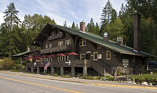
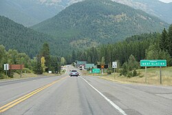
The Belton Chalets are a group of historic hotel buildings in the village of West Glacier, Montana, near the western entrance to Glacier National Park. The chalet buildings were built in 1910-11 by the Great Northern Railway (GN) as the first component of the railroad's ambitious program of hotel, road, and trail construction in Glacier. The buildings featured a "Swiss Chalet" architectural style that set the style for much of the Great Northern's building program in Glacier. Ultimately, the site included five buildings, including a dining hall and a hotel facility.
The Glacier Park Company, a subsidiary of the Great Northern Railway (GN), constructed and operated hotels, chalets, and other visitor facilities in Glacier National Park, Montana and Waterton Lakes National Park, Alberta from the 1910s through 1960. Operating as a concessionaire of the National Park Service, the company operated from a summer base in East Glacier Park, Montana, near the company's flagship Glacier Park Hotel; winter headquarters were in St. Paul, Minnesota. Originally known as the Glacier Park Hotel Company, the corporate name was shortened to Glacier Park Company in 1943.
Babb is a small unincorporated farming and ranching community in Glacier County, Montana, United States, on the Blackfeet Indian Reservation. The community experiences a large influx of tourists in the summer months as it is the gateway to the Many Glacier area of Glacier National Park. For statistical purposes, the United States Census Bureau has defined Babb as a census-designated place (CDP). It had a population of 174 at the 2010 census.
The Great Northern Railway Buildings are a set of five building complexes in or near Glacier National Park in Montana. They were built by the Great Northern Railway during the period of the park's founding to provide a unified tourist experience to visitors to the park, using the Swiss chalet as a building model. The building complexes, each separately listed on the National Register of Historic Places, are:

The Glacier National Park Tourist Trails, including the Inside Trail, South Circle Trail and North Circle Trail, were established in Glacier National Park to connect a series of tourist camps and hotels established by the Great Northern Railway between 1910 and 1915. Prior to the construction of the Going-to-the-Sun Road, these trails were the primary form of circulation within the park. The trail system includes a number of bridges.

The following articles relate to the history, geography, geology, flora, fauna, structures and recreation in Glacier National Park (U.S.), the U.S. portion of the Waterton-Glacier International Peace Park.

Louis Warren Hill, was an American railroad executive. He was the president and board chairman of the Great Northern Railway, which served a substantial area of the Upper Midwest, the northern Great Plains, and Pacific Northwest.

The Regional designations of Montana vary widely within the U.S state of Montana. The state is a large geographical area that is split by the Continental Divide, resulting in watersheds draining into the Pacific Ocean, Gulf of Mexico and Hudson's Bay. The state is approximately 545 miles (877 km) east to west along the Canada–United States border and 320 miles (510 km) north to south. The fourth largest state in land area, it has been divided up in official and unofficial ways into a variety of regions. Additionally, Montana is part of a number of larger federal government administrative regions.
Samuel L. Bartlett was an American architect who worked in Saint Paul, Minnesota, in the early 1900s. He was appointed to the position of architect with the Great Northern Railway in 1905. Bartlett was tasked to bring to reality the vision of Great Northern President Louis W. Hill for great destination hotels in the newly created Glacier National Park (U.S.). Several of the lodges and stations Bartlett designed for the Great Northern are listed in the National Register of Historic Places.