West Harrison, Indiana

Last updated

West Harrison, Indiana
West Harrison, Indiana.jpg
Dearborn County Indiana Incorporated and Unincorporated areas West Harrison Highlighted 1882790.svg
Location of West Harrison in Dearborn County, Indiana.
Coordinates: 39°15′29″N84°49′22″W / 39.25806°N 84.82278°W / 39.25806; -84.82278
Country United States
State Indiana
County Dearborn
Township Harrison
Area
[1]
  Total0.23 sq mi (0.59 km2)
  Land0.22 sq mi (0.57 km2)
  Water0.01 sq mi (0.02 km2)
Elevation
[2]
515 ft (157 m)
Population
 (2020)
  Total325
  Density1,470.59/sq mi (567.61/km2)
Time zone UTC-5 (Eastern (EST))
  Summer (DST) UTC-4 (EDT)
ZIP code
47060
Area code 812
FIPS code 18-82790 [3]
GNIS feature ID2397732 [2]

West Harrison is a town in Harrison Township, Dearborn County, Indiana, United States. The population was 289 at the 2010 census.

Contents

West Harrison's former school West Harrison School.jpg
West Harrison's former school

History

Settlers at West Harrison found numerous mounds constructed by Indians. West Harrison was laid out in 1813, the same year its twin city of Harrison, Ohio, was founded. [4] [5]

Geography

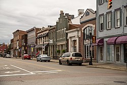
West Harrison is located just across the Indiana state line from Harrison, Ohio. The two towns are divided by State Street.

According to the 2010 census, West Harrison has a total area of 0.228 square miles (0.59 km2), of which 0.22 square miles (0.57 km2) (or 96.49%) is land and 0.008 square miles (0.02 km2) (or 3.51%) is water. [6]

Demographics

Historical population
CensusPop.Note
1880 290
1890 32010.3%
1900 304−5.0%
1910 281−7.6%
1920 258−8.2%
1930 2798.1%
1940 31111.5%
1950 308−1.0%
1960 34110.7%
1970 39515.8%
1980 328−17.0%
1990 318−3.0%
2000 284−10.7%
2010 2891.8%
2020 32512.5%
U.S. Decennial Census [7]

2010 census

As of the census [8] of 2010, there were 289 people, 136 households, and 68 families living in the town. The population density was 1,313.6 inhabitants per square mile (507.2/km2). There were 174 housing units at an average density of 790.9 per square mile (305.4/km2). The racial makeup of the town was 99.0% White, 0.3% African American, 0.3% Native American, and 0.3% Asian. Hispanic or Latino of any race were 0.3% of the population.

There were 136 households, of which 21.3% had children under the age of 18 living with them, 30.1% were married couples living together, 13.2% had a female householder with no husband present, 6.6% had a male householder with no wife present, and 50.0% were non-families. 43.4% of all households were made up of individuals, and 11% had someone living alone who was 65 years of age or older. The average household size was 2.13 and the average family size was 2.94.

The median age in the town was 42.2 years. 17.3% of residents were under the age of 18; 9.7% were between the ages of 18 and 24; 27.7% were from 25 to 44; 32.9% were from 45 to 64; and 12.5% were 65 years of age or older. The gender makeup of the town was 52.6% male and 47.4% female.

2000 census

As of the census [3] of 2000, there were 284 people, 142 households, and 70 families living in the town. The population density was 3,120.3 inhabitants per square mile (1,204.8/km2). There were 151 housing units at an average density of 1,659.1 per square mile (640.6/km2). The racial makeup of the town was 99.30% White, 0.35% Native American, and 0.35% from two or more races. Hispanic or Latino of any race were 0.70% of the population.

West Harrison (at bottom) with Whitewater River. Harrison, Ohio, is the larger town above. The state line runs almost horizontally near the bottom of the picture, along State Street. Harrison-ohio-from-above2.jpg
West Harrison (at bottom) with Whitewater River. Harrison, Ohio, is the larger town above. The state line runs almost horizontally near the bottom of the picture, along State Street.

There were 142 households, out of which 25.4% had children under the age of 18 living with them, 31.0% were married couples living together, 12.7% had a female householder with no husband present, and 50.7% were non-families. 46.5% of all households were made up of individuals, and 9.9% had someone living alone who was 65 years of age or older. The average household size was 2.00 and the average family size was 2.89.

In the town, the population was spread out, with 22.2% under the age of 18, 9.9% from 18 to 24, 33.8% from 25 to 44, 23.2% from 45 to 64, and 10.9% who were 65 years of age or older. The median age was 36 years. For every 100 females, there were 111.9 males. For every 100 females age 18 and over, there were 118.8 males.

The median income for a household in the town was $21,500, and the median income for a family was $23,750. Males had a median income of $32,344 versus $20,313 for females. The per capita income for the town was $12,667. About 32.4% of families and 31.6% of the population were below the poverty line, including 47.3% of those under the age of eighteen and 17.9% of those 65 or over.

Notable people

Related Research Articles

<span class="mw-page-title-main">Royal Center, Indiana</span> Town in Indiana, United States

Royal Center is a town in Boone Township, Cass County, Indiana, United States. The population was 861 at the 2010 census.

<span class="mw-page-title-main">Alton, Indiana</span> Town in Indiana, United States

Alton is a town in Boone Township, Crawford County, Indiana, United States. The population was 29 at the 2020 census.

<span class="mw-page-title-main">Milltown, Indiana</span> Town in Indiana, United States

Milltown is a town in Whiskey Run Township in Crawford County, Indiana and in Blue River and Spencer townships in Harrison County. The population was 818 at the time of the 2010 census.

<span class="mw-page-title-main">Bright, Indiana</span> Census-designated place in Indiana, United States

Bright is an unincorporated community and census-designated place (CDP) in Dearborn County, Indiana, United States. The population was 5,814 at the 2020 census.

<span class="mw-page-title-main">Dillsboro, Indiana</span> Town in Indiana, United States

Dillsboro is a town in Clay Township, Dearborn County, Indiana, United States. As of 2020, the population is 1,360.

<span class="mw-page-title-main">Greendale, Indiana</span> City in Indiana, United States

Greendale is a city in Dearborn County, Indiana, United States. The population was 4,520 at the 2010 census.

<span class="mw-page-title-main">St. Leon, Indiana</span> Town in Indiana, United States

St. Leon or Saint Leon is a town in Kelso Township, Dearborn County, Indiana, United States. The population was 678 at the 2010 census.

<span class="mw-page-title-main">Albany, Indiana</span> Town in Indiana, United States

Albany is a town in Delaware and Randolph counties in the U.S. state of Indiana, along the Mississinewa River. The population was 2,295 at the 2020 census. It is part of the Muncie, IN Metropolitan Statistical Area.

<span class="mw-page-title-main">Daleville, Indiana</span> Town in Indiana, United States

Daleville is a town in Salem Township, Delaware County, Indiana, United States. The population was 1,651 at the 2020 census. It is part of the Muncie, IN Metropolitan Statistical Area.

<span class="mw-page-title-main">Eaton, Indiana</span> Town in Indiana, United States

Eaton is a town in Union Township, Delaware County, Indiana, along the Mississinewa River. The population was 1,595 at the 2020 census. It is part of the Muncie Metropolitan Statistical Area.

<span class="mw-page-title-main">Selma, Indiana</span> Town in Indiana, United States

Selma is a town in Liberty Township, Delaware County, Indiana, United States. As of the 2020 census, the town had a total population of 747. It is part of the Muncie, IN Metropolitan Statistical Area.

<span class="mw-page-title-main">Lanesville, Indiana</span> Town in Indiana, United States

Lanesville is a town in Franklin Township, Harrison County, Indiana, United States. The population was 935 at the 2010 census.

<span class="mw-page-title-main">New Middletown, Indiana</span> Town in Indiana, United States

New Middletown is a town in Webster Township, Harrison County, Indiana, United States. The population was 93 at the 2010 census.

<span class="mw-page-title-main">Brooksburg, Indiana</span> Town in Indiana, United States

Brooksburg is a town in Milton Township, Jefferson County, Indiana, United States. The population was 81 at the 2010 census.

<span class="mw-page-title-main">Dupont, Indiana</span> Town in Indiana, United States

Dupont is a town in Lancaster Township, Jefferson County, Indiana, United States. The population was 339 at the 2010 census.

<span class="mw-page-title-main">Denver, Indiana</span> Town in Indiana, United States

Denver is a town in Jefferson Township, Miami County, in the U.S. state of Indiana. The population was 478 at the 2020 census.

<span class="mw-page-title-main">Paragon, Indiana</span> Town in Indiana, United States

Paragon is a town in Ray Township, Morgan County, in the U.S. state of Indiana. The population was 556 at the 2020 census, down from 659 in 2010.

<span class="mw-page-title-main">Rising Sun, Indiana</span> City in Indiana, United States

Rising Sun is a city in Randolph Township and the county seat of Ohio County, Indiana, United States, along the Ohio River. It is also the only incorporated community in the county. The population of Rising Sun was 2,304 at the 2010 census.

<span class="mw-page-title-main">Clear Lake, Indiana</span> Town in Indiana, United States

Clear Lake is a town located in the northeast corner of Steuben County, Indiana, in Clear Lake Township. As such, is the northeasternmost community in the State of Indiana. The population was 339 at the 2010 census.

<span class="mw-page-title-main">Poneto, Indiana</span> Town in Indiana, United States

Poneto is a town in Chester, Harrison and Liberty townships, Wells County, in the U.S. state of Indiana. The population was 166 at the 2010 census.

References

  1. "2020 U.S. Gazetteer Files". United States Census Bureau. Retrieved March 16, 2022.
  2. 1 2 U.S. Geological Survey Geographic Names Information System: West Harrison, Indiana
  3. 1 2 "U.S. Census website". United States Census Bureau . Retrieved January 31, 2008.
  4. Shaw, Archibald (1915). History of Dearborn County, Indiana: Her People, Industries and Institutions. Unigraphic. pp.  170.
  5. History of Dearborn and Ohio Counties, Indiana. F. E. Weakley. 1885. pp.  533.
  6. "G001 - Geographic Identifiers - 2010 Census Summary File 1". United States Census Bureau. Archived from the original on February 13, 2020. Retrieved July 25, 2015.
  7. "Census of Population and Housing". Census.gov. Retrieved June 4, 2015.
  8. "U.S. Census website". United States Census Bureau . Retrieved December 11, 2012.