
The Canadian Shield, also called the Laurentian Shield or the Laurentian Plateau, is a geologic shield, a large area of exposed Precambrian igneous and high-grade metamorphic rocks. It forms the North American Craton, the ancient geologic core of the North American continent. Glaciation has left the area with only a thin layer of soil, through which exposures of igneous bedrock resulting from its long volcanic history are frequently visible. As a deep, common, joined bedrock region in eastern and central Canada, the shield stretches north from the Great Lakes to the Arctic Ocean, covering over half of Canada and most of Greenland; it also extends south into the northern reaches of the continental United States.

Lake Winnipeg is a very large, relatively shallow 24,514-square-kilometre (9,465 sq mi) lake in North America, in the province of Manitoba, Canada. Its southern end is about 55 kilometres (34 mi) north of the city of Winnipeg. Lake Winnipeg is Canada's sixth-largest freshwater lake and the third-largest freshwater lake contained entirely within Canada, but it is relatively shallow excluding a narrow 36 m (118 ft) deep channel between the northern and southern basins. It is the eleventh-largest freshwater lake on Earth. The lake's east side has pristine boreal forests and rivers that were in 2018 inscribed as Pimachiowin Aki, a UNESCO World Heritage Site. The lake is 416 km (258 mi) from north to south, with remote sandy beaches, large limestone cliffs, and many bat caves in some areas. Manitoba Hydro uses the lake as one of the largest reservoirs in the world. There are many islands, most of them undeveloped.

Mistastin crater is a meteorite crater in Labrador, Canada which contains the roughly circular Mistastin Lake. The lake is approximately 16 km (9.9 mi) in diameter, while the estimated diameter of the original crater is 28 km (17 mi). The age of the crater is calculated to be 36.6 ± 2 million years (Eocene).
West Hawk is a meteorite crater in Manitoba, Canada.
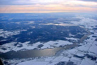
Winnipeg River is a Canadian river that flows roughly northwest from Lake of the Woods in the province of Ontario to Lake Winnipeg in Manitoba. This river is 235 kilometres (146 mi) long from the Norman Dam in Kenora to its mouth at Lake Winnipeg. Its watershed is 106,500 square kilometres (41,100 sq mi) in area, mainly in Canada. About 29,000 square kilometres (11,000 sq mi) of the watershed is in northern Minnesota, United States.

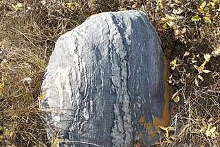
Petroforms, also known as boulder outlines or boulder mosaics, are human-made shapes and patterns made by lining up large rocks on the open ground, often on quite level areas. Petroforms in North America were originally made by various Native American and First Nation tribes, who used various terms to describe them. Petroforms can also include a rock cairn or inukshuk, an upright monolith slab, a medicine wheel, a fire pit, a desert kite, sculpted boulders, or simply rocks lined up or stacked for various reasons. Old World petroforms include the Carnac stones and many other megalithic monuments.
Pinawa is a local government district and small community of 1,331 residents located in southeastern Manitoba, Canada. It is 110 kilometres north-east of Winnipeg. The town is situated on the Canadian Shield within the western boundary of Whiteshell Provincial Park, which lies near the Manitoba-Ontario provincial boundary. Administratively, the town includes the surrounding area, and is officially the Local Government District of Pinawa. Except for a small eastern border with the unorganized area of the Eastman Region, it is surrounded by the Rural Municipalities of Lac du Bonnet to the north and Whitemouth to the south, but is independent of either one. The community lies on the north bank of the Winnipeg River in the southeastern part of the Local Government District.
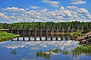
The Whiteshell Laboratories, originally known as the Whiteshell Nuclear Research Establishment (WNRE) was an Atomic Energy of Canada (AECL) laboratory in Manitoba, northeast of Winnipeg. It was originally built as a home for the experimental WR-1 reactor, but over time came to host a variety of experimental systems, including a SLOWPOKE reactor and the Underground Research Laboratory to study nuclear waste disposal. Employment peaked in the early 1970s at about 1,300, but during the 1980s the experiments began to wind down, and in 2003 the decision was made to close the site. As of 2017 the site is undergoing decommissioning with a planned completion date in 2024. The decommissioning process for WR-1 involves transporting low-level nuclear waste to another Canadian Nuclear Laboratories (CNL) research site, Chalk River Laboratories in Ottawa for containment, and encasing the reactor in concrete. The details of this process continue to be criticized, evaluated, and revised.

Eastern Manitoba, or the Eastman Region, is an informal geographic region of the Canadian province of Manitoba. It is bounded on the north by the Winnipeg River and Lake Winnipeg, on the east by the Manitoba-Ontario border, on the south by the Canada–US border, and on the west by the Red River. With a population of 128,855 as of the 2021 Canadian census, the Eastman Region is the second most populous region outside of the Winnipeg Metropolitan Region.
Beausejour is a town in the Canadian province of Manitoba. It is 46 kilometres northeast of Winnipeg, just west of the Canadian Shield and Whiteshell Provincial Park. The French name Beauséjour [beau + séjour] means "beautiful stay". The town is surrounded by the Rural Municipality of Brokenhead.

Whiteshell Provincial Park is a provincial park in southeast Manitoba, approximately 120 kilometres (75 mi) east of the city of Winnipeg. The park is considered to be a Class II protected area under the IUCN protected area management categories. It is 275,210 hectares in size.
The Whiteshell River is one of the major rivers in Whiteshell Provincial Park, in southeastern Manitoba, Canada, near the Ontario border. This river is close to some petroform sites that are about 2000 years old or older. The name "whiteshell" is in reference to the Meegis or cowry shells used by Ojibwa peoples in their ceremonies and teachings, especially the Midewiwin, and as recorded in their birch bark scrolls.

The deepwater sculpin is a species of freshwater fish in the family Cottidae of order Scorpaeniformes. It is a glacial relict, native to a limited number of deep, cold lakes in Canada and the United States.
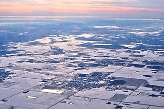
Southern Manitoba is the southernmost area of the Canadian province of Manitoba. Southern Manitoba encompasses the Winnipeg Metropolitan Region, Westman Region, Central Plains Region, Eastman Region, and Pembina Valley Region, as well as the Manitoba portion of Red River Valley. Holding a population of over one million, seven of the ten cities in Manitoba are located in this area, including Winnipeg, Brandon, Portage la Prairie, Selkirk, Morden, Winkler, and Steinbach.

Manitou, akin to the Haudenosaunee orenda, is the spiritual and fundamental life force among Algonquian groups in the Native American theology. It is omnipresent and manifests everywhere: organisms, the environment, events, etc. Aashaa monetoo means "good spirit," while otshee monetoo means "bad spirit." When the world was created, the Great Spirit, Aasha Monetoo, gave the land to the indigenous peoples, the Shawnee in particular.
Falcon Lake is an unincorporated urban centre at the western end of Falcon Lake situated in the southeasternmost section of the Whiteshell Provincial Park in the Canadian province of Manitoba. It is the major entry point to the Whiteshell from the Trans-Canada Highway. Three provincially operated campgrounds, Falcon Creek, Falcon Beach and Falcon Lakeshore, picnic areas, a swimming beach and adjacent public boat launch, several cottage lot divisions and numerous tourist services make the community a favored entrance point to the provincial park. In 2003, 40% of park visitors entered the park at the Falcon Lake checkpoint.
Provincial Trunk Highway 44 is an east-west provincial highway in the Eastman Region of the Canadian province of Manitoba.
Caddy Lake is a lake on the Whiteshell River in south-eastern Manitoba, Canada near the Manitoba–Ontario border. McGillivray Creek drains into the lake on its west side. It is within Whiteshell Provincial Park near West Hawk Lake. The lake has a surface area of about 300 hectares and a maximum depth of 5.7 metres (19 ft).
The geology of Saskatchewan can be divided into two main geological regions, the Precambrian Canadian Shield and the Phanerozoic Western Canadian Sedimentary Basin. Within the Precambrian shield exists the Athabasca sedimentary basin. Meteorite impacts have altered the natural geological formation processes. The prairies were most recently affected by glacial events in the Quaternary period.
The La Vérendrye Trail is a series of highways in the Canadian province of Manitoba commemorating the oldest waterway fur-trading route in the province. It is named after Pierre Gaultier de Varennes, sieur de La Vérendrye, an explorer and fur-trader who is often credited as being the first European to visit what is now southern Manitoba.


