West Okoboji, Iowa

Last updated
West Okoboji, Iowa
Dickinson County Iowa Incorporated and Unincorporated areas West Okoboji Highlighted.svg
Location of West Okoboji, Iowa
Coordinates: 43°21′0″N95°9′32″W / 43.35000°N 95.15889°W / 43.35000; -95.15889 Coordinates: 43°21′0″N95°9′32″W / 43.35000°N 95.15889°W / 43.35000; -95.15889
Country Flag of the United States.svg  United States
State Flag of Iowa.svg  Iowa
County Dickinson
Area
[1]
  Total1.38 sq mi (3.57 km2)
  Land1.25 sq mi (3.25 km2)
  Water0.12 sq mi (0.32 km2)
Elevation
1,417 ft (432 m)
Population
 (2020)
  Total308
  Density245.61/sq mi (94.81/km2)
Time zone UTC-6 (Central (CST))
  Summer (DST) UTC-5 (CDT)
ZIP code
51351
Area code 712
FIPS code 19-84450
GNIS feature ID0462892

West Okoboji is a city in Dickinson County, Iowa, United States. The population was 308 at the time of the 2020 census. [2] The city is located on West Okoboji Lake, from which it takes its name. It is part of the Iowa Great Lakes region.

Contents

Geography

West Okoboji is located at 43°21′0″N95°9′32″W / 43.35000°N 95.15889°W / 43.35000; -95.15889 (43.350090, -95.158945). [3]

According to the United States Census Bureau, the city has a total area of 1.40 square miles (3.63 km2), of which 1.28 square miles (3.32 km2) is land and 0.12 square miles (0.31 km2) is water. [4]

Demographics

Historical populations
YearPop.±%
1930 112    
1940 117+4.5%
1950 158+35.0%
1960 171+8.2%
1970 210+22.8%
1980 435+107.1%
1990 263−39.5%
2000 432+64.3%
2010 289−33.1%
2020 308+6.6%
Source: "U.S. Census website". United States Census Bureau . Retrieved 2020-03-29. and Iowa Data Center
Source:
U.S. Decennial Census [5] [2]

These statistics can be skewed by the "summer" population which swells between May and September as West Okoboji, named for the blue water lake of the same name, is a premier vacation city in the area. Lake Okoboji is known as one of the three "true blue water" lakes in the world, due primarily to its glacial origins and spring fed sources.

2010 census

As of the census [6] of 2010, there were 289 people, 147 households, and 87 families residing in the city. The population density was 225.8 inhabitants per square mile (87.2/km2). There were 382 housing units at an average density of 298.4 per square mile (115.2/km2). The racial makeup of the city was 98.6% White, 0.3% African American, 0.3% from other races, and 0.7% from two or more races. Hispanic or Latino of any race were 1.4% of the population.

There were 147 households, of which 10.9% had children under the age of 18 living with them, 53.7% were married couples living together, 2.7% had a female householder with no husband present, 2.7% had a male householder with no wife present, and 40.8% were non-families. 36.1% of all households were made up of individuals, and 21.1% had someone living alone who was 65 years of age or older. The average household size was 1.97 and the average family size was 2.54.

The median age in the city was 59.5 years. 11.1% of residents were under the age of 18; 4.5% were between the ages of 18 and 24; 11.7% were from 25 to 44; 36.9% were from 45 to 64; and 35.6% were 65 years of age or older. The gender makeup of the city was 47.4% male and 52.6% female.

2000 census

As of the census [7] of 2000, there were 432 people, 216 households, and 130 families residing in the city. The population density was 348.2 inhabitants per square mile (134.4/km2). There were 437 housing units at an average density of 352.2 per square mile (136.0/km2). The racial makeup of the city was 97.45% White, 0.93% African American, 0.69% Native American, 0.23% Asian, and 0.69% from two or more races.

There were 216 households, out of which 28.2% had children under the age of 18 living with them, 42.6% were married couples living together, 15.7% had a female householder with no husband present, and 39.4% were non-families. 34.3% of all households were made up of individuals, and 20.4% had someone living alone who was 65 years of age or older. The average household size was 2.00 and the average family size was 2.50.

In the city, the population was spread out, with 22.0% under the age of 18, 13.4% from 18 to 24, 15.0% from 25 to 44, 25.0% from 45 to 64, and 24.5% who were 65 years of age or older. The median age was 45 years. For every 100 females, there were 83.8 males. For every 100 females age 18 and over, there were 71.1 males.

The median income for a household in the city was $32,083, and the median income for a family was $41,250. Males had a median income of $32,500 versus $18,750 for females. The per capita income for the city was $24,853. About 16.2% of families and 16.3% of the population were below the poverty line, including 35.2% of those under age 18 and 5.4% of those age 65 or over.

Education

The community is served by the Okoboji Community School District. [8] The district was established on July 1, 1988 by the merger of the Arnolds Park and Milford school districts. [9] Okoboji High School in Milford is the local high school.

Related Research Articles

<span class="mw-page-title-main">Dickinson County, Iowa</span> County in Iowa, United States

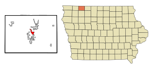
Dickinson County is a county located in the U.S. state of Iowa. As of the 2020 census, the population was 17,703. The county seat is Spirit Lake. The county was organized in 1857 and is named in honor of Daniel S. Dickinson, a U.S. Senator for New York.

<span class="mw-page-title-main">Fulton, Illinois</span> Place in Illinois, United States

Fulton is a city in Whiteside County, Illinois, United States. The population was 3,481 at the 2010 census, down from 3,881 in 2000. Fulton is located across the Mississippi River from Clinton, Iowa.

<span class="mw-page-title-main">Harpers Ferry, Iowa</span> City in Iowa, United States

Harpers Ferry is a city in Taylor Township, Allamakee County, Iowa, United States. The population was 262 at the time of the 2020 census.

<span class="mw-page-title-main">Moulton, Iowa</span> City in Iowa, United States

Moulton is a city in Appanoose County, Iowa, United States. The population was 607 at the time of the 2020 census.

<span class="mw-page-title-main">Fostoria, Iowa</span> City in Iowa, United States

Fostoria is a city in Clay County, Iowa, United States. The population was 230 in the 2020 census, unchanged from the 2000.

<span class="mw-page-title-main">Arnolds Park, Iowa</span> City in Iowa, United States

Arnolds Park is a city in Dickinson County, Iowa, United States. The population was 1,110 in the 2020 census, a decline from the 1,162 population in the 2000 census.

<span class="mw-page-title-main">Milford, Iowa</span> City in Iowa, United States

Milford is a city in Dickinson County, Iowa, United States. The population was 3,321 at the time of the 2020 census. The town includes many businesses related to its location in the Iowa Great Lakes region and is often referred to as the southern gateway to the Iowa Great Lakes.

<span class="mw-page-title-main">Okoboji, Iowa</span> City in Iowa, United States

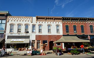
Okoboji is a city in Dickinson County, Iowa, United States, along the eastern shore of West Okoboji Lake in the Iowa Great Lakes region. At the time of the 2020 census, its population was 768.

<span class="mw-page-title-main">Spirit Lake, Iowa</span> City in Iowa, United States

Spirit Lake is a city in Dickinson County, Iowa, United States. The population was 5,439 at the 2020 census. It is the county seat of Dickinson County.

<span class="mw-page-title-main">Wahpeton, Iowa</span> City in Iowa, United States

Wahpeton is a city in Dickinson County, Iowa, United States. The population was 345 at the time of the 2020 census.

<span class="mw-page-title-main">Maynard, Iowa</span> City in Iowa, United States

Maynard is a city in Fayette County, Iowa, United States. The population was 476 at the time of the 2020 census.

<span class="mw-page-title-main">Hills, Iowa</span> City in Iowa, United States

Hills is a city in Johnson County, Iowa, United States. It is part of the Iowa City, Iowa Metropolitan Statistical Area. The population was 863 at the time of the 2020 census. It is part of the Iowa City Community School District.

<span class="mw-page-title-main">Hancock, Iowa</span> City in Iowa, United States

Hancock is a city in Pottawattamie County, Iowa, United States, along the West Nishnabotna River. The population was 200 at the time of the 2020 census.

<span class="mw-page-title-main">Minden, Iowa</span> City in Iowa, United States

Minden is a city in Pottawattamie County, Iowa, United States. The population was 600 at the time of the 2020 census. It has possessed a post office since 1875.

<span class="mw-page-title-main">Dixon, Iowa</span> City in Iowa, USA

Dixon is a city in Scott County, Iowa, United States. The population was 202 at the time of the 2020 census.

<span class="mw-page-title-main">Donahue, Iowa</span> City in Iowa, United States

Donahue is a city in Scott County, Iowa, United States. The population was 335 at the 2020 census. The city has a mayor-council form of government.

<span class="mw-page-title-main">Maysville, Iowa</span> City in Iowa, USA

Maysville is a city in Scott County, Iowa, United States. The population was 156 at the time of the 2020 census.

<span class="mw-page-title-main">Haysville, Pennsylvania</span> Borough in Pennsylvania, United States

Haysville is a borough in Allegheny County, Pennsylvania, U.S., along the Ohio River. The population was 70 according to the 2010 census, making it the least-populated municipality in Allegheny County.

<span class="mw-page-title-main">Williston, Tennessee</span> City in Tennessee, United States

Williston is a city in Fayette County, Tennessee, United States. The population was 395 at the 2010 census.

<span class="mw-page-title-main">Wilton, North Dakota</span> City in North Dakota, United States

Wilton is a city in Burleigh and McLean counties in North Dakota, United States. It is part of the "Bismarck, ND Metropolitan Statistical Area" or "Bismarck-Mandan". The population was 718 at the 2020 census. Founded in 1899, Wilton was named by General W. D. Washburn after the town of Wilton in his native state of Maine.

References

  1. "2020 U.S. Gazetteer Files". United States Census Bureau. Retrieved March 16, 2022.
  2. 1 2 "2020 Census State Redistricting Data". census.gov. United states Census Bureau. Retrieved 12 August 2021.
  3. "US Gazetteer files: 2010, 2000, and 1990". United States Census Bureau. 2011-02-12. Retrieved 2011-04-23.
  4. "US Gazetteer files 2010". United States Census Bureau . Retrieved 2012-05-11.
  5. "Census of Population and Housing". Census.gov. Retrieved June 4, 2015.
  6. "U.S. Census website". United States Census Bureau . Retrieved 2012-05-11.
  7. "U.S. Census website". United States Census Bureau . Retrieved 2008-01-31.
  8. "Okoboji" (PDF). Iowa Department of Education . Retrieved 2020-03-24.
  9. "REORGANIZATION & DISSOLUTION ACTIONS SINCE 1965-66" (PDF). Iowa Department of Education. Archived from the original (PDF) on 2019-02-09. Retrieved 2020-03-22.