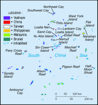
The Spratly Islands are a disputed archipelago in the South China Sea. Composed of islands, islets, cays, and more than 100 reefs, sometimes grouped in submerged old atolls, the archipelago lies off the coasts of the Philippines, Malaysia, and southern Vietnam. Named after the 19th-century British whaling captain Richard Spratly who sighted Spratly Island in 1843, the islands contain less than 2 km2 of naturally occurring land area, which is spread over an area of more than 425,000 km2 (164,000 sq mi).

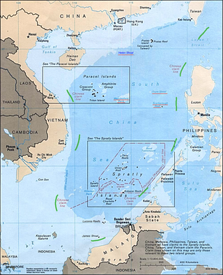
The South China Sea is a marginal sea of the Western Pacific Ocean. It is bounded in the north by South China, in the west by the Indochinese Peninsula, in the east by the islands of Taiwan and northwestern Philippines, and in the south by the Indonesian islands of Borneo, eastern Sumatra and the Bangka Belitung Islands, encompassing an area of around 3,500,000 km2 (1,400,000 sq mi). It communicates with the East China Sea via the Taiwan Strait, the Philippine Sea via the Luzon Strait, the Sulu Sea via the straits around Palawan, and the Java Sea via the Karimata and Bangka Straits. The Gulf of Thailand and the Gulf of Tonkin are part of the South China Sea.

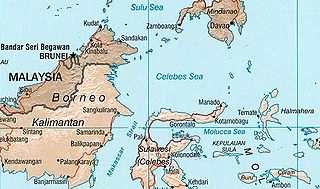
The Celebes Sea or Sulawesi Sea of the western Pacific Ocean is bordered on the north by the Sulu Archipelago and Sulu Sea and Mindanao Island of the Philippines, on the east by the Sangihe Islands chain, on the south by Sulawesi's Minahasa Peninsula, and the west by northern Kalimantan in Indonesia. It extends 420 miles (675 km) north-south by 520 mi (840 km) east-west and has a total surface area of 110,000 square miles (280,000 km2), to a maximum depth of 20,300 feet (6,200 m). South of the Cape Mangkalihat, the sea opens southwest through the Makassar Strait into the Java Sea.

An exclusive economic zone (EEZ), as prescribed by the 1982 United Nations Convention on the Law of the Sea, is an area of the sea in which a sovereign state has exclusive rights regarding the exploration and use of marine resources, including energy production from water and wind. EEZ does not define the ownership of any maritime features within the EEZ.

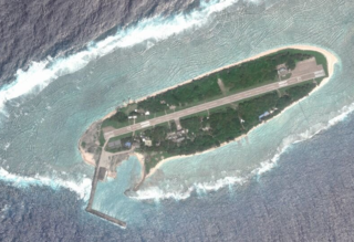
Taiping Island, also known as Itu Aba, and various other names, is the largest of the naturally occurring Spratly Islands in the South China Sea. The island is elliptical in shape being 1.4 kilometres (0.87 mi) in length and 0.4 kilometres (0.25 mi) in width, with an area of 46 hectares. It is located on the northern edge of the Tizard Bank. The runway of the Taiping Island Airport is easily the most prominent feature on the island, running its entire length.

Scarborough Shoal, also known as Bajo de Masinloc, Huangyan Island, Minzhu Jiao and Panatag Shoal, are two skerries (rocks) located between Macclesfield Bank to the west and Luzon to the east. Luzon is 220 kilometres (119 nmi) away and the nearest landmass. The atoll is a disputed territory claimed by the Republic of the Philippines through the 1734 Velarde map, while the People's Republic of China and the Republic of China (Taiwan) claim it through the disputed nine-dash line. The atoll's status is often discussed in conjunction with other territorial disputes in the South China Sea such as those involving the Spratly Islands, and the 2012 Scarborough Shoal standoff. It was administered by the Philippines as part of its Zambales province, until 2012, when a standoff was initiated by China through the use of warships against fishing boats, resulting in effective capture by the Chinese maritime forces.

Philippines and the Spratly Islands – this article discusses the policies, activities and history of the Republic of the Philippines in the Spratly Islands from the Philippine perspective. Non-Philippine viewpoints regarding Philippine occupation of several islands are currently not included in this article.

The Spratly Islands dispute is an ongoing territorial dispute between Brunei, China, Malaysia, the Philippines, Taiwan, and Vietnam concerning "ownership" of the Spratly Islands, a group of islands and associated "maritime features" located in the South China Sea. The dispute is characterized by diplomatic stalemate and the employment of military pressure techniques in the advancement of national territorial claims. All except Brunei occupy some of the maritime features.

The nine-dash line, also referred to as the eleven-dash line by Taiwan, is a set of line segments on various maps that accompanied the claims of the People's Republic of China and the Republic of China in the South China Sea. The contested area includes the Paracel Islands, the Spratly Islands, the Pratas Island and the Vereker Banks, the Macclesfield Bank, and the Scarborough Shoal. Certain places have undergone land reclamation by the PRC, ROC, and Vietnam. The People's Daily of the PRC uses the term Duànxùxiàn (断续线) or Nánhǎi Duànxùxiàn, while the ROC government uses the term Shíyīduàn xiàn.

Territorial disputes in the South China Sea involve conflicting island and maritime claims in the South China Sea by several sovereign states, namely the People's Republic of China (PRC), Taiwan, Brunei, Malaysia, the Philippines, and Vietnam. The disputes involve the islands, reefs, banks, and other features of the region, including the Spratly Islands, Paracel Islands, Scarborough Shoal, and various boundaries in the Gulf of Tonkin. The waters near the Indonesian Natuna Islands, which some regard as geographically part of the South China Sea, are disputed as well. Maritime disputes also extend beyond the South China Sea, as in the case of the Senkaku Islands and the Socotra Rock, which lie in the East China Sea.

Bilateral relations between China and the Philippines had significantly progressed since the 1990s, peaking during the Philippine presidencies of Gloria Macapagal Arroyo and Rodrigo Duterte. However, relations have become increasingly tense due to territorial disputes in the South China Sea, particularly since the 2012 Scarborough Shoal standoff; in 2013, the Philippine government under President Benigno Aquino III in 2013 filed an arbitration case at The Hague against China over China's expansive maritime claims. The policy of current Philippine president Bongbong Marcos aims for distancing relations between the Philippines and China in favor of the country's relationship with the United States. The current policy of the general secretary of the Chinese Communist Party aims for greater influence over the Philippines, and the region in general, while combating American influence.
The Scarborough Shoal standoff is a dispute between the Philippines and the People's Republic of China over the Scarborough Shoal. Tensions began on April 8, 2012, after the attempted apprehension by the Philippine Navy of eight mainland Chinese fishing vessels near the shoal.

The bilateral foreign relations between the Republic of the Philippines and Republic of China (Taiwan) are a subject of China–Philippines relations. Among other issues between the two are the South China Sea dispute and the political status of Taiwan.

The South China Sea Arbitration was an arbitration case brought by the Republic of the Philippines against the People's Republic of China (PRC) under Annex VII of the United Nations Convention on the Law of the Sea concerning certain issues in the South China Sea, including the nine-dash line introduced by the mainland-based Republic of China since as early as 1947. A tribunal of arbitrators appointed the Permanent Court of Arbitration (PCA) as the registry for the proceedings.

The article covers events that are related to the South China Sea dispute. In the South China Sea, historically China, Japan and France have disputed over Spratly and Paracel Islands. Presently, the Paracel Islands are disputed among China (PRC), Taiwan (ROC), and Vietnam, while Pratas Island is contested between China and Taiwan. Additionally, the Spratly Islands are subject to intertwined claims by China, Taiwan, Vietnam, the Philippines, Malaysia, and Brunei. Because of this, numerous countries with territorial disputes have had conflicts in the South China Sea since the past.
During the administration of President Barack Obama, there were six instances of the United States Navy performing a freedom of navigation operation (FONOP) in the South China Sea (SCS). During the same period the USN also performed multiple other FONOPs in other parts of the world. The SCS operations involved Arleigh-Burke class guided missile destroyers assigned to United States Seventh Fleet. The U.S. FONOP program began in 1979 and the Department of Defense (DoD) keeps public records of FONOPs since 1991 on its website. The Department of State (DoS) provided guidance to the DoD on conducting FONOPs, with a particular focus on the South China Sea and East China Sea, while pushing back on the People's Republic of China and their "excessive territorial claims", specifically with the Spratly Islands, Paracel Islands, and Senkaku Islands.
The exclusive economic zone of the Philippines mandated by UNCLOS consists of four subzones. It covers 2,263,816 square kilometers (874,064 sq mi) of sea. The Philippines has 7,641 islands comprising the Philippine archipelago. The coordinates are between 116° 40', and 126° 34' E longitude and 4° 40' and 21° 10' N latitude. It is bordered by the Philippine Sea to the east and north, the South China Sea to the west, and the Celebes Sea to the south.
Malaysia claims an exclusive economic zone (EEZ) of 334,671 km2 (129,217 sq mi) with 200 nautical miles from its shores. The EEZ includes much of the southern area of the South China Sea. Malaysia has the 29th longest coastline of 4,675 km (2,905 mi). The coastline comprises two distinct parts of Malaysia. The Peninsular Malaysia's coastline to the west is 2,068 km (1,285 mi) and East Malaysia's coastline is 2,607 km (1,620 mi). They are separated by the South China Sea. The total land area, including inland bodies of water, of Malaysia is 330,803 km2 (127,724 sq mi). Peninsular Malaysia borders Thailand in the north, while East Malaysia borders Brunei and Indonesia on the island of Borneo.

On March 22, 2021, a diplomatic incident started after the Philippines filed a diplomatic protest against China due to the presence of more than 200 Chinese fishing vessels at Whitsun Reef as early as March 7, 2021. The reef is part of the contested Spratly Islands in the South China Sea.
The first 100 days of Rodrigo Duterte's presidency began on June 30, 2016, the day Rodrigo Duterte was inaugurated as the 16th president of the Philippines. The concept of the first 100 days of a presidential term was first adopted in the Philippines by President Corazon Aquino from the United States and has since been used as a gauge of presidential success and activism, and is a considered the "honeymoon period" where traditional critics are urged to refrain from detracting the new president. The 100th day of his presidency ended at noon on October 8, 2016.


