West Wickham, Cambridgeshire

Last updated

West Wickham
Cambridgeshire UK location map.svg
Red pog.svg
West Wickham
Location within Cambridgeshire
Population423 (2001) [1]
440 (2011) [2]
OS grid reference TL6149
District
Shire county
Region
Country England
Sovereign state United Kingdom
Post town Cambridge
Postcode district CB21
Dialling code 01223
Police Cambridgeshire
Fire Cambridgeshire
Ambulance East of England
Website www.westwickham.org
List of places
UK
England
Cambridgeshire
52°07′13″N0°21′27″E / 52.1202°N 0.3575°E / 52.1202; 0.3575 Coordinates: 52°07′13″N0°21′27″E / 52.1202°N 0.3575°E / 52.1202; 0.3575

West Wickham is a village and civil parish in South Cambridgeshire, England, 10 miles south-east of Cambridge on the border with Suffolk.

Contents

History

The parish of West Wickham and Streetly End is approximately rectangular and covers an area of 2,931 acres. Its straight southern border follows the ancient track of Wool Street that divide it from the parishes of Linton and Horseheath. Field boundaries separate it from West Wratting to the north, and Balsham to the west. Its eastern boundary follows the border with Suffolk. [3]

At the time of the Domesday Book the parish contained three settlements: Wickham at the centre, plus the hamlets of Enhale (now Yen Hall) and Streetly (now Streetly End). Streetly End still has a number of houses, but Yen Hall consisted only of a farmhouse by the 18th century. By the 14th century a hamlet had appeared at "Bovetoun", and still exists as Burton End.

The village was known as Wickham until the 14th century, at which time the prefix "West" was added, presumably to distinguish it from the Wickhams in Suffolk (now known as Wickham Market and Wickham Skeith). [3] The name "Wickham" means "homestead associated with a vicus, an earlier Romano-British settlement". [4]

Church

The village was listed as having a church in 1200, but nothing survives of the building from that time. The present parish church, dedicated to Saint Mary consists of a chancel, nave with north chapel and south porch, and west tower. The oldest part of the church appears to be the tower, which may date from the 13th century. The nave and chancel were built in the 14th century. [3]

Village life

The village has little in the way of amenities. It has a village hall [5] and recreation ground, which is used for sports, leisure activities and events by local residents and clubs. A post office also operates once a week from the village hall.

It had one public house, the White Horse, that opened in the early 19th century but has closed in recent years. Former pubs included the White Hart at Burton End, certainly open by the mid-18th century but closed by 1933, and the Chequers at Streetly End, which opened in the early 19th century. [3] The Chequers closed after a fire destroyed its thatched roof in 1985. [6]

A National school replaced a Sunday School in the village in 1878. After 1937 older children attended Linton Village College, and the school closed in 1971 with primary children instead attending Balsham. [3]

Related Research Articles

<span class="mw-page-title-main">The Abingtons, Cambridgeshire</span> Human settlement in England

The Abingtons are a community in South Cambridgeshire consisting of two small villages: Little Abington and Great Abington, about 7 miles (11 km) south east of Cambridge.

<span class="mw-page-title-main">Fordham, Cambridgeshire</span> Human settlement in England

Fordham is a village in rural Cambridgeshire, England. Fordham is part of the East Cambridgeshire district. It is four miles north of Newmarket, as well as being close to the settlements of Soham, Burwell, Isleham, Mildenhall and Chippenham.

<span class="mw-page-title-main">Linton, Cambridgeshire</span> Human settlement in England

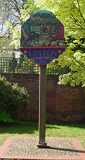
Linton is a village and civil parish in Cambridgeshire, England, on the border with Essex. The village is approximately 8 miles (13 km) southeast from the city and county town of Cambridge. The A1307 passes through the village.

<span class="mw-page-title-main">Abington Pigotts</span> Human settlement in England

Abington Pigotts is a small village in Cambridgeshire, England about 4 miles (6 km) northwest of Royston, Hertfordshire.

<span class="mw-page-title-main">Balsham</span> Human settlement in England

Balsham is a rural village and civil parish in the county of Cambridgeshire, England, which has much expanded since the 1960s and is now one of several dormitory settlements of Cambridge. The village is south east of the centre of Cambridge beyond the A11 road and near Newmarket and Haverhill where many residents work and shop.

<span class="mw-page-title-main">Babraham</span> Human settlement in England

Babraham is a village and civil parish in the South Cambridgeshire district of Cambridgeshire, England, about 6 miles (9.7 km) south-east of Cambridge on the A1307 road.

<span class="mw-page-title-main">Barrington, Cambridgeshire</span> Human settlement in England

Barrington is a small village and civil parish in the South Cambridgeshire district of Cambridgeshire, England. The village is about 7 miles (11 km) south-west of Cambridge, between Haslingfield and Shepreth.

<span class="mw-page-title-main">Bartlow</span> Human settlement in England

Bartlow is a small village and civil parish in the South Cambridgeshire district of Cambridgeshire, England, about 12 miles (19 km) south-east of Cambridge and 7 miles (11 km) west of Haverhill in Suffolk. The River Granta runs through the village.

<span class="mw-page-title-main">Chippenham, Cambridgeshire</span> Human settlement in England

Chippenham is a village and civil parish in Cambridgeshire, England, part of East Cambridgeshire district around 4 miles (6.4 km) north-east of Newmarket and 10 miles (16 km) north-east of Cambridge.

<span class="mw-page-title-main">Dullingham</span> Human settlement in England

Dullingham is a small village and civil parish in East Cambridgeshire, England. It is situated 4 miles (6 km) south of Newmarket and 14 miles (23 km) east of Cambridge.

<span class="mw-page-title-main">Wickham Skeith</span> Human settlement in England

Wickham Skeith is a village and civil parish in Suffolk, England, about 5 miles to the west of Eye and about 3 miles east of Finningham.

<span class="mw-page-title-main">Litlington, Cambridgeshire</span> Human settlement in England

Litlington is a village and civil parish in the East of England region and the county of Cambridgeshire in the United Kingdom. The village lies approximately 14 miles (23 km) southwest of Cambridge and 3 miles (4.8 km) northwest of Royston.

<span class="mw-page-title-main">Shudy Camps</span> Human settlement in England

Shudy Camps is a village in the south-east corner of Cambridgeshire, England, near the border of Essex and Suffolk, and is part of the Chilford Hundred. In 2001, according to the census, the population was 310, increasing to 338 at the 2011 Census. The area of the village is 951 hectares. It includes the nearby hamlet of Mill Green. The highest point in the parish is 383' ASL at Mill Green.

<span class="mw-page-title-main">Steeple Morden</span> Human settlement in England

Steeple Morden is a village and civil parish in Cambridgeshire, England, about 15 miles (24 km) south west of Cambridge and 5 miles (8 km) west of Royston. It is part of the South Cambridgeshire local government district.

<span class="mw-page-title-main">Stetchworth</span> Human settlement in England

Stetchworth is a small village and civil parish in East Cambridgeshire, England, 3 miles (5 km) to the south of the horse-racing centre of Newmarket and around 12 miles (19 km) east of Cambridge.

<span class="mw-page-title-main">Castle Camps (village)</span> Human settlement in England

Castle Camps is a village and civil parish in the South Cambridgeshire district, in the county of Cambridgeshire, England. It is 15 miles (24 km) south-east of Cambridge and near to the borders of Suffolk and Essex and to the town of Haverhill. The population of the parish was 684 at the 2011 Census.

<span class="mw-page-title-main">West Wratting</span> Human settlement in England

West Wratting is a village and civil parish 10 miles southeast of Cambridge in Cambridgeshire. At 390 feet (120 m) above sea level, it can claim to be one of the highest villages in Cambridgeshire.

Graveley is a village and civil parish in South Cambridgeshire, England.

<span class="mw-page-title-main">Snailwell</span> Human settlement in England

Snailwell is a small village and civil parish in East Cambridgeshire, England around 4 kilometres (2.5 mi) north of Newmarket.

Whaddon is a village and civil parish in South Cambridgeshire, England, 6 kilometres (3.7 mi) north of Royston.

References

  1. 2001 census
  2. "Civil Parish population 2011". Neighbourhood Statistics. Office for National Statistics. Retrieved 25 July 2016.
  3. 1 2 3 4 5 A History of the County of Cambridge and the Isle of Ely. Vol. 6. 1978. pp. 113–124.
  4. A. D. Mills (2003). "A Dictionary of British Place-Names".
  5. West Wickham parish website
  6. Chequers Public House British Listed Buildings

Commons-logo.svg Media related to West Wickham, Cambridgeshire at Wikimedia Commons