
U.S. Route 5 (US 5) is a north–south United States Numbered Highway running through the New England states of Connecticut, Massachusetts, and Vermont. Significant cities along the route include New Haven, Connecticut; Hartford, Connecticut; and Springfield, Massachusetts. From Hartford northward to St. Johnsbury, Vermont, the road closely follows the route of the Connecticut River.

Brighton is a former town and current neighborhood of Boston, Massachusetts, United States, located in the northwestern corner of the city. It is named after the English city of Brighton. Initially Brighton was part of Cambridge, and known as "Little Cambridge". Brighton separated from Cambridge in 1807 after a bridge dispute, and was annexed to Boston in 1874. For much of its early history, it was a rural town with a significant commercial center at its eastern end.
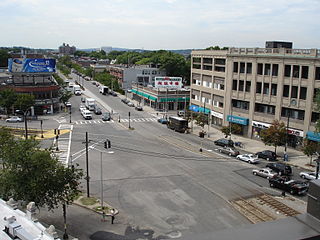
Allston is an officially recognized neighborhood within the City of Boston, Massachusetts. It was named after the American painter and poet Washington Allston. It comprises the land covered by the zip code 02134. For the most part, Allston is administered collectively with the adjacent neighborhood of Brighton. The two are often referred to together as Allston–Brighton. Boston Police Department District D-14 covers the Allston-Brighton area and a Boston Fire Department Allston station is located in Union Square which houses Engine 41 and Ladder 14. Engine 41 is nicknamed "The Bull" to commemorate the historic stockyards of Allston.

Kenmore Square is a square in the Fenway–Kenmore neighborhood of Boston, Massachusetts. It is formed by the crossing of Beacon Street,Commonwealth Avenue, and Brookline Avenue. It is the eastern terminus of U.S. Route 20, the longest U.S. Highway. The Citgo sign is a prominent landmark in Kenmore Square, and Fenway Park is just to the south. Kenmore station is located under the square, with a surface bus terminal inside the square.

The Great Bridge over the Charles River connected Cambridge, Massachusetts, to what is now known as Allston, Boston, Massachusetts. The Great Bridge was built in 1660–1662 at what was then called Brighton Street, and was the first bridge to span the Charles. A toll was authorized in 1670. The bridge was rebuilt in 1862.
The Grand Junction Railroad is an 8.55-mile (13.76 km) long railroad in the Boston, Massachusetts, area, connecting the railroads heading west and north from Boston. The line is notable for its railroad bridge over the Charles River that passes under the Boston University Bridge between Boston and Cambridge, Massachusetts.
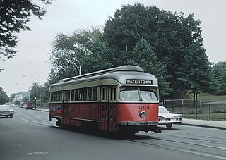
The A branch or Watertown Line was a streetcar line in the Boston, Massachusetts, area, operating as a branch of the Massachusetts Bay Transportation Authority Green Line. The line ran from Watertown through Newton Corner, Brighton, and Allston to Kenmore Square, then used the Boylston Street subway and Tremont Street subway to reach Park Street station.

Commonwealth Avenue is a major street in the cities of Boston and Newton, Massachusetts. It begins at the western edge of the Boston Public Garden, and continues west through the neighborhoods of the Back Bay, Kenmore Square, Boston University, Allston, Brighton and Chestnut Hill. It continues as part of Route 30 through Newton until it crosses the Charles River at the border of the town of Weston.
The 145th Street Bridge is a four-lane swing bridge across the Harlem River in New York City, connecting 145th Street and Lenox Avenue in Manhattan with 149th Street and River Avenue in the Bronx. The bridge is operated and maintained by the New York City Department of Transportation.

The Slade's Ferry Bridge was a steel swing truss bridge that spanned the Taunton River between Somerset, Massachusetts and Fall River, Massachusetts. It was built in 1875 and removed in 1970. The bridge had two levels: an upper deck carrying the Providence, Warren and Bristol Railroad, and a lower deck for road traffic. A swing section allowed river traffic to pass. The alignment of the bridge carried it from Remington Street in Fall River to the junction of Riverside Avenue, Brayton Avenue and Wilbur Avenue in Somerset.

The Charles River Reservation Parkways are parkways that run along either side of the Charles River in eastern Massachusetts. The roads are contained within the Charles River Reservation and the Upper Charles River Reservation, and fall within a number of communities in the greater Boston metropolitan area. The Charles River parks extend from the Charles River Dam, where the Charles empties into Boston Harbor, to Riverdale Park in the West Roxbury neighborhood of Boston. Most of the roadways within the parks are listed on the National Register of Historic Places as a unit, although Storrow Drive and Memorial Drive are listed as part of the Charles River Basin Historic District.

The River Street Bridge is a bridge on the Charles River in Boston, Massachusetts, connecting River Street in Cambridge to Cambridge Street in Allston near the southern end of the Harvard University campus. It was built in 1925 by the Commonwealth of Massachusetts Metropolitan District Commission.

The John W. Weeks Memorial Bridge, usually called the Weeks Footbridge or simply Weeks Bridge, is a pedestrian bridge over the Charles River, located four miles northwest of downtown Boston on the Harvard University campus. The bridge connects Harvard’s original Cambridge campus with the Harvard Business School and many of the school’s athletic facilities in Allston.

Blue Hills Parkway is a historic parkway that runs in a straight line from a crossing of the Neponset River, at the south border of Boston to the north edge of the Blue Hills Reservation in Milton, Massachusetts. It was built in 1893 to a design by the noted landscape architect, Charles Eliot, who is perhaps best known for the esplanades along the Charles River. The parkway is a connecting road between the Blue Hills Reservation and the Neponset River Reservation, and was listed on the National Register of Historic Places in 2003.

The Arsenal Street Bridge is a bridge crossing the Charles River and connecting Arsenal Street in Watertown, Massachusetts to Western Avenue in Allston, Boston, Massachusetts. It was built in 1925 by the Commonwealth of Massachusetts Metropolitan District Commission.

Allston Street station is a light rail station on the MBTA Green Line B branch, located between the westbound travel lanes and frontage road of Commonwealth Avenue at Allston Street in Allston, Boston, Massachusetts. The station is not accessible. It has two side platforms, located on the near sides of the Allston Street grade crossing, to serve the line's two tracks.

Warren Street station is a light rail station on the MBTA Green Line B branch, located on Commonwealth Avenue at Warren Street in Allston, Boston, Massachusetts. The station is not accessible. It has two side platforms, located on the near sides of the Warren Street grade crossing, to serve the line's two tracks.

Soldiers Field Road is a major crosstown parkway in Boston, Massachusetts, running west to east from U.S. Route 20 in the northwest corner of Brighton to the Boston University Bridge. It follows the course of the Charles River and also passes by the campuses of Harvard University and Boston University. The road is named for the area south of the road on a bend in the Charles River. On June 5, 1890, Henry Lee Higginson presented Harvard College a gift of 31 acres of land, which he called Soldiers Field, given in honor of his friends who died in the Civil War: James Savage, Jr., Charles Russell Lowell, Edward Barry Dalton, Stephen George Perkins, James Jackson Lowell, and Robert Gould Shaw. This land later became the home of Harvard Crimson athletics.


