Zeeland is the westernmost and least populous province of the Netherlands. The province, located in the southwest of the country, borders North Brabant to the east, South Holland to the north, as well as the country of Belgium to the south and west. It consists of a number of islands and peninsulas and a strip bordering the Flemish provinces of East and West Flanders. Its capital is Middelburg with a population of 48,544 as of November 2019, although the largest municipality in Zeeland is Terneuzen. Zeeland has two seaports: Vlissingen and Terneuzen. Its area is 2,934 square kilometres (1,130 sq mi), of which 1,151 square kilometres (440 sq mi) is water; it has a population of 383,689.

The Scheldt is a 435-kilometre-long (270 mi) river that flows through northern France, western Belgium, and the southwestern part of the Netherlands, with its mouth at the North Sea. Its name is derived from an adjective corresponding to Old English sceald ("shallow"), Modern English shoal, Low German schol, West Frisian skol, and obsolete Swedish skäll ("thin").

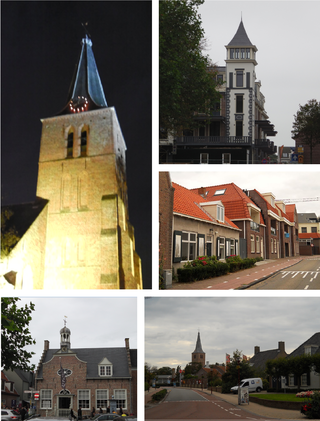
Terneuzen is a city and municipality in the southwestern Netherlands, in the province of Zeeland, in the middle of Zeelandic Flanders. With almost 55,000 inhabitants, it is the most populous municipality of Zeeland.

Walcheren is a region and former island in the Dutch province of Zeeland at the mouth of the Scheldt estuary. It lies between the Eastern Scheldt in the north and the Western Scheldt in the south and is roughly the shape of a rhombus. The two sides facing the North Sea consist of dunes and the rest of its coastline is made up of dykes. Middelburg, the provincial capital, lies at Walcheren's centre. Vlissingen, 9 kilometres (5.6 mi) to the south, is the main harbour and the third municipality is Veere.

Veere is a municipality with a population of 22,000 and a town with a population of 1,500 in the southwestern Netherlands, in the region of Walcheren in the province of Zeeland.

The Western Scheldt in the province of Zeeland in the southwestern Netherlands, is the estuary of the Scheldt river. This river once had several estuaries, but the others are now disconnected from the Scheldt, leaving the Westerschelde as its only direct route to the sea. The Western Scheldt is an important shipping route to the Port of Antwerp, Belgium. Unlike the Eastern Scheldt estuary, it could not be closed off from the sea by a dam as part of the Delta Works. Instead, the dykes around it have been heightened and reinforced.

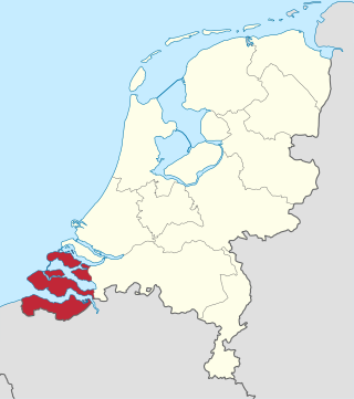
Zeelandic Flanders is the southernmost region of the province of Zeeland in the south-western Netherlands. It lies south of the Western Scheldt that separates the region from the remainder of Zeeland and the Netherlands to the north. Zeelandic Flanders is bordered to the south and to the east by Belgium.

Zuid-Beveland is part of the province of Zeeland in the Netherlands north of the Western Scheldt and south of the Eastern Scheldt.

Breskens is a harbour town on the Westerschelde in the municipality of Sluis, Netherlands. Its population is 4,787.
Domburg is a seaside resort on the North Sea, on the northwest coast of Walcheren in the Dutch province of Zeeland. It is a part of the municipality of Veere, and lies about 11 km northwest of the city of Middelburg, the provincial capital.

The Battle of the Scheldt in World War II was a series of military operations led by the First Canadian Army, with Polish and British units attached, to open up the shipping route to Antwerp so that its port could be used to supply the Allies in north-west Europe. Under acting command of the First Canadian's Lieutenant-General Guy Simonds, the battle took place in northern Belgium and southwestern Netherlands from 2 October to 8 November 1944.

Zeelandic is a group of Friso-Franconian language varieties spoken in the southwestern parts of the Netherlands. It is currently considered a Low Franconian dialect of Dutch, but there have been movements to promote the status of Zeelandic from a dialect of Dutch to a separate regional language, which have been denied by the Dutch Ministry of Internal Affairs. More specifically, it is spoken in the southernmost part of South Holland (Goeree-Overflakkee) and large parts of the province of Zeeland, with the notable exception of eastern Zeelandic Flanders.

Zoutelande is a village in the southwestern Netherlands. It is located in the municipality of Veere, Zeeland, between Dishoek and Westkapelle on the former island Walcheren. On 1 January 2005 it had 1,556 inhabitants. Originally, Zoutelande was mainly an agricultural village. The village's character changed slowly into a tourist resort as the demand for beach recreation rose from about the middle of the 19th century.

The Port of Ghent is the third busiest seaport in Belgium, located in Ghent, East Flanders in the Flemish Region. The first port of Ghent was situated at the river Scheldt and later on at the Leie. Since the Middle Ages Ghent has sought for a connection to the sea. In the 13th century via the Lieve canal to the Zwin near Damme, in the 16th century via the Sassevaart, in the 17th century via the Ghent–Bruges canal. Since the 19th century, the Ghent–Terneuzen Canal connects the port via the Western Scheldt to the North Sea. The port of Ghent is accessible by ships of the Panamax size, and in February 2015 the construction of a new lock at Terneuzen was announced, which will maintain near-parity with those of the Panama Canal expansion project.

The Battle of the Scheldt also known as the Battle of Walcheren was a naval battle that took place on 29 January 1574 during the Eighty Years' War and the Anglo–Spanish War. The battle was fought between a Dutch rebel Sea Beggar fleet under Lodewijk van Boisot and a Spanish fleet under Julián Romero. The Spanish fleet was attempting to relieve the Spanish held town of Middelburg which was under siege but the fleet under Boisot intercepted them and were victorious with the destruction or capture of nearly fifteen ships. Middelburg as a result then surrendered only nine days later along with Arnemuiden.
The Battle of Walcheren Causeway was an engagement of the Battle of the Scheldt between the 5th Canadian Infantry Brigade, elements of the British 52nd (Lowland) Infantry Division and troops of the German 15th Army in 1944. It was the first of many conflicts on and around Walcheren Island during the Scheldt battles. It was also the second major battle fought over a terrain feature known as the Sloedam during the Second World War.

Operation Infatuate was the code name given to an Anglo-Canadian operation in November 1944 during the Second World War to open the port of Antwerp to shipping and relieve logistical constraints. The operation was part of the wider Battle of the Scheldt and involved two assault landings from the sea by the 4th Special Service Brigade and the 52nd (Lowland) Division. At the same time the 2nd Canadian Infantry Division would force a crossing of the Walcheren Causeway.

Rear Admiral Anthony Follett Pugsley was a British naval officer. During the Second World War he served as a successful destroyer captain, landed the 3rd Canadian Division on D-Day, and planned and executed the amphibious landings on Walcheren during a critically important phase in the Battle of the Scheldt in late 1944.

The Inundation of Walcheren was the intentional, but uncontrolled military inundation, effected by bombing the sea dikes of the former island of Walcheren in Zeeland by the Allies on and after 3 October 1944 in the context of Operation Infatuate during the Battle of the Scheldt after the Allied Invasion of Normandy during World War II. Though the inundation was justified by military necessity, it is controversial whether it was proportional in view of the predictable devastating effects for the civilian population, and the ecology of the island. The fact that the breaches in the sea dikes of the island remained open for a very long time, subjecting the island to the full impact of the twice-daily tides, caused severe damage to agricultural land and infrastructure, and severe hardship for the civilian population. Leaving the breaches open for such a long time, which was unavoidable due to the war-time lack of resources making closing impossible, subjected them to scouring by the tides, that widened and deepened them to such an extent that closing them eventually became extremely difficult, necessitating the development of new dike-building techniques, such as the use of caissons. The last breach was closed on 23 October 1945 and the draining of the island took until early 1946. Only after that could rebuilding the infrastructure and reconstructing the housing stock and the island's economy start. Walcheren was spared during the North Sea Flood of 1953 that devastated many other parts of Zeeland.
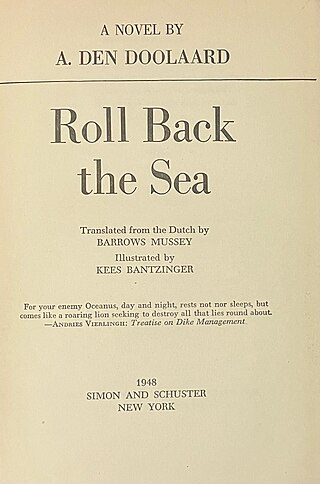
Het verjaagde water is a 1947 Dutch non-fiction novel written by A. den Doolaard, which gives an account of the recovery works to repair dike breaches after the October 1944 Inundation of Walcheren as part of operations by The Allies of World War II during Operation Infatuate. Researchers from Delft University of Technology have found high levels of historical accuracy in den Doolaard's descriptions of the events that took place, the methods used to close the dikes and the key people involved. Den Doolaard assigned pseudonyms to most of the main characters and organisations. The name A. den Doolaard is also a pseudonym, the author’s real name being Cornelis Johannes George Spoelstra Jr.


