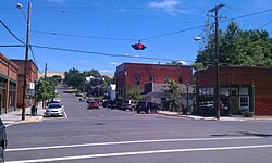
Weston, Oregon

Last updated

Weston, Oregon
City of Weston, Oregon.jpg
Historic Main street.
Umatilla County Oregon Incorporated and Unincorporated areas Weston Highlighted.svg
Location in Oregon
Coordinates: 45°48′59″N118°25′33″W / 45.81639°N 118.42583°W / 45.81639; -118.42583
Country United States
State Oregon
County Umatilla
Incorporated 1878
Area
[1]
  Total0.68 sq mi (1.76 km2)
  Land0.68 sq mi (1.76 km2)
  Water0.00 sq mi (0.00 km2)
Elevation
[2]
1,821 ft (555 m)
Population
 (2020) [3]
  Total706
  Density1,038.24/sq mi (400.92/km2)
Time zone UTC-8 (Pacific)
  Summer (DST) UTC-7 (Pacific)
ZIP code
97886
Area code 541
FIPS code 41-80350 [4]
GNIS feature ID2412241 [2]

Weston is a city in Umatilla County, Oregon, United States. It was originally a post office called Mitchell's Station, established in February 1867. In September 1869, T.T. Lieuallen renamed the post office after his hometown, Weston, Missouri. [5] The population was 667 at the 2010 census. It is part of the Pendleton Hermiston Micropolitan Statistical Area.

Contents

History

Weston was incorporated by the Oregon Legislative Assembly on October 19, 1878. [6]

Weston is best known for its connection with novelist Nard Jones (1904–1972), who lived in the city with his parents between 1919 and 1927, and whose first novel Oregon Detour was set in an Oregon town of 600 inhabitants called "Creston". When his novel, written according to the tenets of the New Realism literary movement (established years before by Sherwood Anderson, Sinclair Lewis and others) was published in 1930, many of the residents were convinced that his characters were based on local inhabitants, and considered the work a slander against the town. [7] While the legend that Jones was sued and ran out of town for his book is not true, members of the town made an effort to locally suppress access to the book: copies of the novel were stolen from the local library; after the novel became the subject for a high school student's book report, his English teacher removed the book from both the reading list and the high school library. According to George Venn, local literary historian, even in the 1980s, "trying to figure out or trying to remember who the 'real people' in the novel is still a local pastime." [8]

Geography

According to the United States Census Bureau, the city has a total area of 0.68 square miles (1.76 km2), all of it land. [9] Weston is located at the foot of the Blue Mountains, on Pine Creek.

Climate

This region experiences warm (but not hot) and dry summers, with no average monthly temperatures above 69 °F (21 °C). According to the Köppen Climate Classification system, Weston has a warm-summer Mediterranean climate, abbreviated "Csb" on climate maps. [10]

Demographics

Historical population
CensusPop.Note
1880 446
1890 56827.4%
1900 62610.2%
1910 499−20.3%
1920 59519.2%
1930 384−35.5%
1940 49829.7%
1950 67936.3%
1960 78315.3%
1970 660−15.7%
1980 7198.9%
1990 606−15.7%
2000 71718.3%
2010 667−7.0%
2020 7065.8%
U.S. Decennial Census [11] [3]

2010 census

As of the census of 2010, there were 667 people, 252 households, and 171 families residing in the city. The population density was 980.9 inhabitants per square mile (378.7/km2). There were 271 housing units at an average density of 398.5 per square mile (153.9/km2). The racial makeup of the city was 83.5% White, 0.3% African American, 3.4% Native American, 3.1% Asian, 5.8% from other races, and 3.7% from two or more races. Hispanic or Latino of any race were 8.5% of the population. [4]

There were 252 households, of which 34.5% had children under the age of 18 living with them, 46.0% were married couples living together, 10.3% had a female householder with no husband present, 11.5% had a male householder with no wife present, and 32.1% were non-families. 27.0% of all households were made up of individuals, and 13.9% had someone living alone who was 65 years of age or older. The average household size was 2.65 and the average family size was 3.12. [4]

The median age in the city was 39.5 years. 25.8% of residents were under the age of 18; 6.4% were between the ages of 18 and 24; 25.3% were from 25 to 44; 26.8% were from 45 to 64; and 15.6% were 65 years of age or older. The gender makeup of the city was 52.0% male and 48.0% female. [4]

2000 census

As of the census of 2000, there were 717 people, 265 households, and 191 families residing in the city. The population density was 1,318.7 inhabitants per square mile (509.2/km2). There were 280 housing units at an average density of 515.0 per square mile (198.8/km2). The racial makeup of the city was 83.40% White, 3.35% Native American, 10.88% from other races, and 2.37% from two or more races. Hispanic or Latino of any race were 15.76% of the population. [4]

There were 265 households, out of which 32.8% had children under the age of 18 living with them, 54.3% were married couples living together, 8.7% had a female householder with no husband present, and 27.9% were non-families. 25.3% of all households were made up of individuals, and 11.3% had someone living alone who was 65 years of age or older. The average household size was 2.71 and the average family size was 3.18. [4]

In the city, the population was spread out, with 28.2% under the age of 18, 6.8% from 18 to 24, 27.1% from 25 to 44, 25.0% from 45 to 64, and 13.0% who were 65 years of age or older. The median age was 37 years. For every 100 females, there were 97.5 males. For every 100 females age 18 and over, there were 97.3 males. [4]

The median income for a household in the city was $36,905, and the median income for a family was $39,063. Males had a median income of $25,682 versus $21,625 for females. The per capita income for the city was $13,089. About 10.0% of families and 12.9% of the population were below the poverty line, including 14.2% of those under age 18 and 14.3% of those age 65 or over. [4]

Related Research Articles

<span class="mw-page-title-main">Weston, Idaho</span> City in Idaho, United States

Weston is a city in Franklin County, Idaho, United States. The population was 437 at the 2010 census. It is part of the Logan, Utah-Idaho Metropolitan Statistical Area. It was first settled in 1865. The community was so named on account of its location at the west bank of the Bear River.

<span class="mw-page-title-main">Weston, Missouri</span> Town in Missouri, United States

Weston is a town in Platte County, Missouri within the United States. The population was 1,641 at the 2010 census.

<span class="mw-page-title-main">Weston, Nebraska</span> Village in Saunder County, Nebraska, United States

Weston is a village in Saunders County, Nebraska, United States. The population was 250 at the 2020 census.

<span class="mw-page-title-main">Haines, Oregon</span> City in Oregon, United States

Haines is a city in Baker County, Oregon, United States. The population was 416 at the 2010 census.

<span class="mw-page-title-main">Barlow, Oregon</span> City in Oregon, United States

Barlow is a city in Clackamas County, Oregon, United States. The population was 133 at the 2020 census. The mayor of Barlow is Michael Lundsten, as of the most recent election in 2018.

<span class="mw-page-title-main">Yoncalla, Oregon</span> City in Oregon, United States

Yoncalla is a city in Douglas County, Oregon, United States. The population was 1,047 at the 2010 census.

<span class="mw-page-title-main">Butte Falls, Oregon</span> City in Oregon, United States

Butte Falls is a city in Jackson County, Oregon, United States. The population was 423 at the 2010 census. As of July 1, 2018, the city's population was estimated to be 450.

<span class="mw-page-title-main">Dunes City, Oregon</span> City in Oregon, United States

Dunes City is a city in Lane County, Oregon, United States. The population was 1,303 at the 2010 census.

<span class="mw-page-title-main">Siletz, Oregon</span> City in Oregon, United States

Siletz is a city in Lincoln County, Oregon, United States. The population was 1,212 at the 2010 census. The city is located next to the Siletz Reservation and is the site of the annual Nesika Illahee Pow Wow in August.

<span class="mw-page-title-main">Harrisburg, Oregon</span> City in Oregon, United States

Harrisburg is a city in Linn County, Oregon, United States. The population was 3,567 at the 2010 census.

<span class="mw-page-title-main">Sodaville, Oregon</span> City in Oregon, United States

Sodaville is a city in Linn County, Oregon, United States. The population was 308 at the 2010 census.

<span class="mw-page-title-main">Gervais, Oregon</span> City in Oregon, United States

Gervais is a city in Marion County, Oregon, United States. The population was 2,595 at the 2020 census. It is part of the Salem Metropolitan Statistical Area.

<span class="mw-page-title-main">Sublimity, Oregon</span> City in Oregon, United States

Sublimity is a city in Marion County, Oregon, United States. The population was 2,967 at the 2020 census. It is part of the Salem Metropolitan Statistical Area.

<span class="mw-page-title-main">Rufus, Oregon</span> City in Oregon, United States

Rufus is a city in Sherman County, Oregon, United States. The population was 249 at the 2010 census. The city was named for an early settler, Rufus Carrol Wallis.

<span class="mw-page-title-main">Adams, Oregon</span> City in Oregon, United States

Adams is a city in Umatilla County, Oregon, United States, located about 13 miles (21 km) northeast of Pendleton on Oregon Route 11. The population was 350 at the 2010 census. It is part of the Pendleton–Hermiston Micropolitan Statistical Area.

<span class="mw-page-title-main">Athena, Oregon</span> City in Oregon, United States

Athena is a city in Umatilla County, Oregon, United States. The population was 1,126 at the 2010 census. It is part of the Hermiston-Pendleton Micropolitan Statistical Area.

<span class="mw-page-title-main">Stanfield, Oregon</span> City in Oregon, United States

Stanfield is a city in Umatilla County, Oregon, United States. The population was 2,043 at the 2010 census. It is part of the Pendleton–Hermiston Micropolitan Statistical Area.

<span class="mw-page-title-main">Banks, Oregon</span> City in Oregon, United States

Banks is a city in Washington County, Oregon, United States which is located in the Tualatin Valley. It is the southern anchor to the Banks–Vernonia State Trail, which is a 21-mile (34 km) long linear trail popular with bicyclists, hikers, and equestrians. The population was 1,777 at the 2010 census. The community was named for John and Nancy Banks, who owned a nearby dairy farm. Incorporated in 1921, it is located in the western part of the county where Oregon Route 6 intersects Oregon Route 47.

<span class="mw-page-title-main">Weston, West Virginia</span> City in West Virginia, United States

Weston is a city in Lewis County, West Virginia, United States. The population was 3,943 at the 2020 census. It is the county seat of Lewis County, and home to the Museum of American Glass in West Virginia and the Trans-Allegheny Lunatic Asylum.

<span class="mw-page-title-main">Rivergrove, Oregon</span> City in Oregon, United States

Rivergrove is a city in Clackamas County, Oregon, United States. A small portion of the city extends into nearby Washington County. Its name is a portmanteau of the Tualatin River, which forms its southern border, and Lake Grove, a community that is now part of Lake Oswego. The population was 370 at the 2010 census.

References

  1. "ArcGIS REST Services Directory". United States Census Bureau. Retrieved October 12, 2022.
  2. 1 2 U.S. Geological Survey Geographic Names Information System: Weston, Oregon
  3. 1 2 "Census Population API". United States Census Bureau. Retrieved October 12, 2022.
  4. 1 2 3 4 5 6 7 8 "U.S. Census website". United States Census Bureau . Retrieved December 21, 2012.
  5. McArthur, Lewis A.; McArthur, Lewis L. (2003) [1928]. Oregon Geographic Names (7th ed.). Portland, Oregon: Oregon Historical Society Press. p. 1025. ISBN   978-0875952772.
  6. Leeds, W. H. (1899). "Special Laws". The State of Oregon General and Special Laws and Joint Resolutions and Memorials Enacted and Adopted by the Twentieth Regular Session of the Legislative Assembly. Salem, Oregon: State Printer: 1095.
  7. Walt Curtis (1995). "Nard Jones (1904–1972)". Oregon Cultural Heritage Commission. Retrieved January 18, 2011.
  8. University Publications. "Oregon Detour Introduction". Oregon State University Press . Retrieved January 18, 2011.
  9. "US Gazetteer files 2010". United States Census Bureau . Retrieved December 21, 2012.
  10. "Weston, Oregon". Weatherbase. CantyMedia. Retrieved June 6, 2015.
  11. "Census of Population and Housing". Census.gov. Retrieved June 4, 2015.