
Reedsville is a census-designated place (CDP) in the Kishacoquillas Valley of Mifflin County, Pennsylvania, United States. The population was 641 at the 2010 census. Reedsville has a high Amish population.

West Falls Church is a census-designated place (CDP) in Fairfax County, Virginia, United States. The population was 29,207 at the 2010 census. Before 2010, West Falls Church was officially named Jefferson. Outside of the Jefferson Village neighborhood, "Jefferson" generally is not used locally to refer to the area bounding Falls Church city to the south and southwest that comprises the CDP. Likewise, "West Falls Church" is rarely used to describe the area but is usually applied to areas west of Falls Church city or near West Falls Church Metro station. The bulk of it is made of subdivisions built in the 1940s and early 1950s, including Jefferson Village, Westlawn, Hillwood, Sleepy Hollow, Woodley, Raymondale and Broyhill Park.

Middle Mouse is an uninhabited island situated 1 kilometre off the north coast of Anglesey. It is notable as the northernmost point of Wales. The island measures a maximum of 207 metres by 110 metres, with a maximum area of 3.7 acres and has a maximum altitude of 16 metres (52') above sea level. It is one of a chain of three islands off the north of Anglesey, the others being Ynys Amlwch and Maen y Bugail.

Cottingham is a large village and civil parish in the East Riding of Yorkshire, England with average affluence. It forms part of Hull’s urban area, and lies 4 miles (6.4 km) north-west of the centre of Kingston upon Hull, and 6 miles (9.7 km) south-east of Beverley on the eastern edge of the Yorkshire Wolds. It has two main shopping streets, Hallgate and King Street, which cross each other near the Church of Saint Mary the Virgin, and a market square called Market Green. Cottingham had a population of 17,164 residents in 2011, making it larger by area and population than many towns. As a result, it is one of the villages claiming to be the largest village in England.
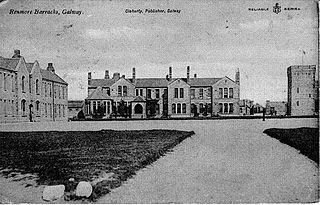
Renmore is a suburb of Galway City, Ireland, situated approximately 2 km to the east of the city. Renmore runs east along the coast and south of Dublin Road, from the shore of Lough Atalia on its west side to Lurgan Park on its east. The area houses approximately 5,000 people and includes Ballyloughane beach, which also has camping facilities.

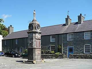
Rhoscolyn is a village and community located on Holy Island, Anglesey, Wales. It is just over five miles south of Holyhead and is the most southerly settlement on the island. The name Rhoscolyn is said to mean "The Moor" (Rhos) of The Column (colyn), referring to a pillar which the Romans put up to mark the edge of their territories. The community population taken from the 2011 census was 542.

Drypool is an area within the city of Kingston upon Hull, England.
Butlers Marston is a village and civil parish on the River Dene in south-eastern Warwickshire, England. The village is part of Stratford-on-Avon district. In the 2001 census it had a population of 226, increasing to 232 in the 2011 Census. Butlers Marston is located one mile south-west of Kineton and roughly four miles south-east of Wellesbourne.
Staplestown is a village and townland in north County Kildare, Ireland, located 40 kilometres west of Dublin. The village has a church, a school and is home to St Kevin's GAA. The local national (primary) school is Scoil Naomh Mhuire National School.

Putnam is an unincorporated community and census-designated place (CDP) in Marengo County, Alabama, United States. As of the 2020 census, its population was 172.

Edlington with Wispington is a civil parish in the East Lindsey district of Lincolnshire, England. It is situated approximately 2 miles (3 km) north-west from the town of Horncastle.

Isycoed is a community in Wrexham County Borough, Wales. It lies around 5 miles to the east of Wrexham, close to the River Dee on the border with England.

Newland is a suburb of Kingston upon Hull, East Riding of Yorkshire, England, in the north-west of the city, a former village on the Hull to Beverley turnpike.
Llanfechell is a village in Anglesey, Wales. It is the largest of several small villages and dispersed settlements that make up Mechell Community Council area. It is 11 miles (18 km) east of Holyhead, and 5.6 miles (9 km) west of Amlwch, in the north of the island.
St Andrew's Church is in Livesey Branch Road, Blackburn, Lancashire, England. It is a redundant Anglican church designed by the Lancaster architect E. G. Paley. The foundation stone was laid in December 1866, but the church was not consecrated until 1877. As first built, the church seated 652, and cost £6,000. Its plan is cruciform, consisting of a nave, north and south transepts, and a chancel with a polygonal apse. There is an incomplete tower in the angle between the south transept and the chancel. Along the sides of the church are paired lancet windows, the transepts contain rose windows, and the windows at the west and east ends of the church incorporate Geometrical tracery. The stained glass in the south wall of the chancel is by Clayton and Bell, and dates from about 1890.

Southcoates is an urban area in the eastern part of Kingston upon Hull, England.

The North Hull Estate is a residential area in the north of Kingston upon Hull, west of the River Hull, built by Hull Corporation in the interwar period.
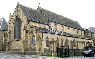
St Patrick's Church is a Roman Catholic church in Bradford, West Yorkshire, England. It was built from 1852 to 1853 and designed by George Goldie. It is situated on the corner of Sedgfield Terrace and Westgate in the city centre. To the south and west of the church is Rebecca Street and Vaughan Street. The church is the oldest Roman Catholic church still in use in the city and is a Grade II listed building.

Preston Road Estate, also known as the East Hull Estate, is a housing estate in the east of Kingston upon Hull built from the 1920s to the 1940s by Hull Corporation. At the beginning of the 21st century considerable redevelopment of the estate took place, with a large community centre established, and demolition or modification of older substandard houses.

St Mary's Church is a Church in Wales parish church in Llanfairpwllgwyngyll, Anglesey, Wales. It was built in 1853 to serve the village in the Diocese of Bangor and is a Grade II-listed building.