
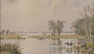
The Wethersfield Cove is a natural inlet in Wethersfield, Connecticut, and a former site of much local trade and travel.
The Wethersfield Cove is a natural inlet in Wethersfield, Connecticut, and a former site of much local trade and travel.
Wethersfield Cove is ten feet above sea level and forty miles from Long Island Sound. It was originally an oxbow in the Connecticut River. It is located near Old Wethersfield, one of the oldest settlements in the United States.
Thomas Deming built his shipyard on the banks of this natural harbor. Deming launched the Tryall, the first ship built in Connecticut, from the cove in 1649. From 1650-1830, trade with the West Indies thrived. Merchants exported lumber, grain, onions, salted beef, fish and pork, and in exchange received salt, sugar, molasses and rum from the Caribbean. "The Cove" was also noted in Revolutionary times as "Blackbird Pond".
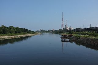
Some citizens have protested the continued discharge of sewage into the cove, especially after the accidental discharge of 20 million gallons of sewage in 1997, and are lobbying for it to stop, but the proposed mitigation efforts would run into the hundreds of millions of dollars. [1] The Metropolitan District Commission of Connecticut's multi-billion dollar Clean Water Project seeks to address this problem. [2]


Sewerage is the infrastructure that conveys sewage or surface runoff using sewers. It encompasses components such as receiving drains, manholes, pumping stations, storm overflows, and screening chambers of the combined sewer or sanitary sewer. Sewerage ends at the entry to a sewage treatment plant or at the point of discharge into the environment. It is the system of pipes, chambers, manholes or inspection chamber, etc. that conveys the sewage or storm water.

Long Island Sound is a marine sound and tidal estuary of the Atlantic Ocean. It lies predominantly between the U.S. state of Connecticut to the north and Long Island in New York to the south. From west to east, the sound stretches 110 mi (180 km) from the East River and the Throgs Neck Bridge in New York City, along the North Shore of Long Island, to Block Island Sound. A mix of freshwater from tributaries, and saltwater from the Atlantic Ocean, Long Island Sound is 21 mi (34 km) at its widest point and varies in depth from 65 to 230 feet.
Uncasville is a village in the town of Montville, Connecticut, United States. It is located in southeastern Montville, at the mouth of the Oxoboxo River where it flows into the Thames River. The name is now applied more generally to all of the east end of Montville, which is the area served by the Uncasville ZIP Code (06382).
New Jersey Meadowlands, also known as the Hackensack Meadowlands after the primary river flowing through it, is a general name for a large ecosystem of wetlands in northeastern New Jersey in the United States, a few miles to the west of New York City. During the 20th century, much of the Meadowlands area was urbanized, and it became known for being the site of large landfills and decades of environmental abuse. A variety of projects began in the late 20th century to restore and conserve the remaining ecological resources in the Meadowlands.
The Cooum River, or simply Koovam, is one of the shortest classified rivers draining into the Bay of Bengal. This river is about 72 km (45 mi) in length, flowing 32 km (20 mi) in the city of Chennai and the rest in rural part. The river is highly polluted in the urban area (Chennai). Along with the Adyar River running parallel to the south and the Kosasthalaiyar River, the river trifurcates the city of Chennai and separates Northern Chennai from Central Chennai. It is also sometimes known as Thiruvallikenni river
The Mill River is a river in New Haven County, Connecticut, United States.
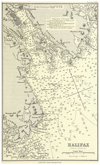
Halifax Harbour is a large natural harbour on the Atlantic coast of Nova Scotia, Canada, located in the Halifax Regional Municipality. Halifax largely owes its existence to the harbour, being one of the largest and deepest ice-free natural harbours in the world. Before Confederation it was one of the most important commercial ports on the Atlantic seaboard. In 1917, it was the site of the world's largest man-made accidental explosion, when the SS Mont-Blanc blew up in the Halifax Explosion on December 6.

A combined sewer is a type of gravity sewer with a system of pipes, tunnels, pump stations etc. to transport sewage and urban runoff together to a sewage treatment plant or disposal site. This means that during rain events, the sewage gets diluted, resulting in higher flowrates at the treatment site. Uncontaminated stormwater simply dilutes sewage, but runoff may dissolve or suspend virtually anything it contacts on roofs, streets, and storage yards. As rainfall travels over roofs and the ground, it may pick up various contaminants including soil particles and other sediment, heavy metals, organic compounds, animal waste, and oil and grease. Combined sewers may also receive dry weather drainage from landscape irrigation, construction dewatering, and washing buildings and sidewalks.
The Stewart B. McKinney National Wildlife Refuge is a 950-acre (384.5 ha) National Wildlife Refuge in ten units across the U.S. state of Connecticut. Located in the Atlantic Flyway, the refuge spans 70 miles (110 km) of Connecticut coastline and provides important resting, feeding, and nesting habitat for many species of wading birds, shorebirds, songbirds and terns, including the endangered roseate tern. Adjacent waters serve as wintering habitat for brant, scoters, American black duck, and other waterfowl. Overall, the refuge encompasses over 900 acres (364.2 ha) of barrier beach, intertidal wetland and fragile island habitats.
House of Hope, also known as Fort Good Hope, was a redoubt and factory in the seventeenth-century Dutch colony of New Netherland. The trading post was located at modern-day Hartford, Connecticut at Park River), a tributary river of the Fresh River. The location of this confluence of rivers is at contemporary Sheldon Street. The fort is recalled today with a nearby avenue called Huyshope, once the center of economic activity in the city.

The Deer Island Waste Water Treatment Plant is located on Deer Island, one of the Boston Harbor Islands in Boston Harbor. The plant is operated by the Massachusetts Water Resources Authority (MWRA) and began partial operations in 1995. The facility was fully operational in 2000 with the completion of the outfall tunnel.
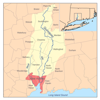
The West River is a 13.5-mile-long (21.7 km) freshwater stream in southern Connecticut. It flows through the towns of Bethany, Woodbridge, New Haven, and West Haven before discharging into New Haven Harbor.

Castro Cove is a "portion of the San Pablo Bay" in Richmond, California located between Point San Pablo and the confluence of Wildcat Creek into Castro Creek.
Mumford Cove is a private association in Southeastern Connecticut located adjacent to Groton Long Point, bordered by Noank Connecticut Haley's Farm nature preserve, Palmer's Cove, and Fisher's Island Sound. It is a part of the town of Groton, Connecticut. The neighborhood was first developed in the late 1960s, and former Connecticut Governor John Dempsey briefly lived there.

Isleworth Ait is a London Wildlife Trust nature reserve, and is a teardrop-shaped island in the River Thames in England, between 3.5-hectare (8.6-acre) and 9.370-acre (3.792 ha). The long ait is on the Tideway facing Old Isleworth and the towpath alongside the Royal Mid-Surrey Golf Club. These places are in the London Boroughs of Hounslow and Richmond upon Thames. The island faces Heron's Place and a number of commercial buildings. It is not open to the public, other than on organised event or volunteering days.
Harbour Solutions is a Canadian public infrastructure project in Halifax, Nova Scotia.
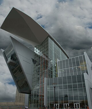
The Connecticut Science Center is a nine-story museum located on the Connecticut River in Hartford, Connecticut designed by César Pelli & Associates, which opened on June 12, 2009. The building measures a total of 154,000 square feet (14,300 m2), including 40,000 square feet (3,700 m2) of interactive exhibits consisting of videos, audios, visuals, tactile components, programs, and live demonstrations.
Hidden Lake is one of five villages located within Haddam, Connecticut, United States. It is governed by the bylaws of the Hidden Lake Association.

Point source water pollution comes from discrete conveyances and alters the chemical, biological, and physical characteristics of water. In the United States, it is largely regulated by the Clean Water Act (CWA). Among other things, the Act requires dischargers to obtain a National Pollutant Discharge Elimination System (NPDES) permit to legally discharge pollutants into a water body. However, point source pollution remains an issue in some water bodies, due to some limitations of the Act. Consequently, other regulatory approaches have emerged, such as water quality trading and voluntary community-level efforts.

The Back Cove South Storage Facility will be the result of a large construction project begun in 2020 in the Back Cove neighborhood of Portland, Maine. Centered on Back Cove Park, between Preble Street to the southwest, Franklin Street to the northeast and Interstate 295 to the southeast, the project—a combined sewer and stormwater overflow —is estimated to cost $40 million, and is the city's largest such project to date. It is designed to reduce combined sewage overflow into both Back Cove and Portland's harbor by 40%. Currently, after heavy rainfall, storm water mixes with sewage and discharges into Casco Bay.