Eyemouth is a small town and civil parish in Berwickshire, in the Scottish Borders area of Scotland. It is two miles east of the main north–south A1 road and eight miles north of Berwick-upon-Tweed.

Lossiemouth is a town in Moray, Scotland. Originally the port belonging to Elgin, it became an important fishing town. Although there has been over 1,000 years of settlement in the area, the present day town was formed over the past 250 years and consists of four separate communities that eventually merged into one. From 1890 to 1975, it was a police burgh as Lossiemouth and Branderburgh.

Stroma is an uninhabited island in the Pentland Firth, between Orkney and the mainland of Scotland. It forms part of the civil parish of Canisbay in Caithness. The name comes from the Old Norse Straumey, meaning "island in the current".
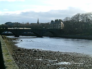
Wick is a town and royal burgh in Caithness, in the far north of Scotland. The town straddles the River Wick and extends along both sides of Wick Bay. "Wick Locality" had a population of 6,954 at the time of the 2011 census, a decrease of 3.8% from 2001.

Lybster is a village on the east coast of Caithness in northern Scotland. It was once a big herring fishing port.

Collieston is a small former fishing village on the North Sea coast in Aberdeenshire, Scotland. The village lies just north of the Sands of Forvie Special Protection Area, between Cruden Bay and Newburgh.
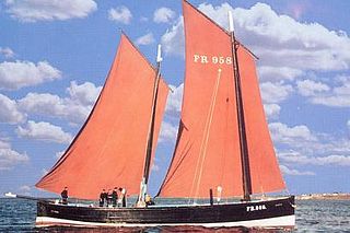
The Fifie is a design of sailing boat developed on the east coast of Scotland. It was a traditional fishing boat used by Scottish fishermen from the 1850s until well into the 20th century. These boats were mainly used to fish for herring using drift nets, and along with other designs of boat were known as herring drifters.

Cellardyke is a village in the East Neuk of Fife, Scotland. The village is to the immediate east of Anstruther and is to the south of Kilrenny.
Reaper is a restored historic Fifie herring drifter which is registered by the National Historic Ships Committee as part of the National Historic Fleet of the UK, and currently operates as a museum ship.
The Scottish east coast fishery has been in existence for more than a thousand years, spanning the Viking Age right up to the present day.
The Moray Firth fishing disaster of August 1848 was one of the worst fishing disasters in maritime history on the east coast of Scotland, and was caused by a severe storm that struck the Moray Firth. The event led to widespread improvements to harbours and significant changes to the design of fishing boats over the remainder of the 19th century.
The Sutherland and Caithness Railway was a Scottish railway company that built a line from Helmsdale, the terminus of the Duke of Sutherland's Railway to Wick and Thurso in Caithness, giving the northern towns access to Inverness. It was driven through by the efforts of the 3rd Duke of Sutherland and the engineer Joseph Mitchell in the face of apathy from interests in Wick.
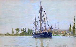
In English, a chasse-marée is a specific, archaic type of decked commercial sailing vessel.
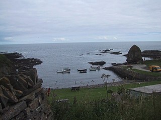
Staxigoe is a former fishing village, located 2 miles east of Wick on the north-eastern coast of the former county of Caithness, Scottish Highlands and is in the Scottish council area of Highland. Its name derives from Norse, "the inlet of the stack". It was once the largest herring salting station in Europe, but its fishing industry went into decline with the construction of a larger port in central Wick.

Ulbster is a scattered crofting hamlet on the eastern coast of Caithness, within the parish of Wick, in the Scottish Highlands, within the Highland Council area. The town of Wick is located seven miles north of the village along the A99 road. To the south of the village, two miles along the A99, lies the ancient port of Whaligoe, where the famous 330 steps were cut into a cliff on the instruction of Thomas Telford in 1786.

Badbea is a former clearance village perched on the steep slopes above the cliff tops of Berriedale on the east coast of Caithness, Scotland. Situated around 5 miles (8 km) north of Helmsdale, the village was settled in the 18th and 19th centuries by families evicted from their homes when the straths of Langwell, Ousdale and Berriedale were cleared for the establishment of sheep farms. The last resident left the village in 1911 and a monument was erected by the son of former inhabitant, Alexander Robert Sutherland, who had emigrated to New Zealand in 1839. Today, the ruins of the village are preserved as a tourist attraction and memorial to the Highland Clearances.

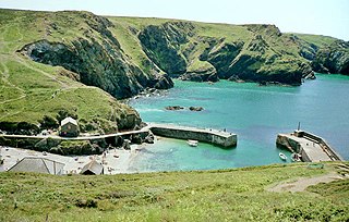
Fishing in Cornwall, England, UK, has traditionally been one of the main elements of the economy of the county. Pilchard fishing and processing was a thriving industry in Cornwall from around 1750 to around 1880, after which it went into an almost terminal decline. During the 20th century the varieties of fish taken became much more diverse and crustaceans such as crab and lobster are now significant. Much of the catch is exported to France due to the higher prices obtainable there. Though fishing has been significantly damaged by overfishing, the Southwest Handline Fishermen's Association has started to revive the fishing industry. As of 2007, stocks were improving. The Cornwall Sea Fisheries Committee is one of 12 committees responsible for managing the corresponding Sea Fisheries District. The Isles of Scilly Sea Fisheries Committee is responsible for the Scilly district.
The John o' Groats Trail is a Scottish long-distance walking route from Inverness to John o' Groats, traversing back lanes, footpaths, shorelines and cliff tops of the Scottish Highlands. The trail gives access to accommodation, meals and shops at the end of each stage of the walk.

Dunbar Harbour is a seaport forming the north-east part of the town of Dunbar, East Lothian, Scotland. It is situated on a point projecting from the North Sea coast of East Lothian into the mouth of the Firth of Forth.