Wheatland, Oregon

Last updated

Wheatland
Wheatland Oregon.JPG
Wheatland
USA Oregon location map.svg
Red pog.svg
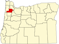
Wheatland
Location within the state of Oregon
Usa edcp location map.svg
Red pog.svg
Wheatland
Wheatland (the United States)
Coordinates: 45°05′33″N123°03′00″W / 45.09250°N 123.05000°W / 45.09250; -123.05000
Country United States
State Oregon
County Yamhill
Elevation
[1]
118 ft (36 m)
Time zone UTC-8 (Pacific (PST))
  Summer (DST) UTC-7 (PDT)
GNIS feature ID1136896 [1]

Wheatland is an unincorporated community in Yamhill County, Oregon, United States. It is near the Willamette River where the Wheatland Ferry takes traffic across the river into Marion County. It is in the Pacific Time Zone.

Contents

See also

Related Research Articles

<span class="mw-page-title-main">Salem, Oregon</span> Capital city of Oregon, United States

Salem is the capital city of the U.S. state of Oregon, and the county seat of Marion County. It is located in the center of the Willamette Valley alongside the Willamette River, which runs north through the city. The river forms the boundary between Marion and Polk counties, and the city neighborhood of West Salem is in Polk County. Salem was founded in 1842, became the capital of the Oregon Territory in 1851, and was incorporated in 1857.

<span class="mw-page-title-main">Willamette River</span> 187-mile Columbia River tributary in northwest Oregon, US

The Willamette River is a major tributary of the Columbia River, accounting for 12 to 15 percent of the Columbia's flow. The Willamette's main stem is 187 miles (301 km) long, lying entirely in northwestern Oregon in the United States. Flowing northward between the Oregon Coast Range and the Cascade Range, the river and its tributaries form the Willamette Valley, a basin that contains two-thirds of Oregon's population, including the state capital, Salem, and the state's largest city, Portland, which surrounds the Willamette's mouth at the Columbia.

<span class="mw-page-title-main">Wilsonville, Oregon</span> City in Oregon, United States

Wilsonville is a city primarily in Clackamas County, Oregon, United States. A portion of the northern section of the city is in Washington County. It was founded as Boones Landing because of the Boones Ferry which crossed the Willamette River at the location; the community became Wilsonville in 1880. The city was incorporated in 1969 with a population of approximately 1,000. The population was 13,991 at the 2000 census, and grew to 19,509 as of 2010. Slightly more than 90% of residents at the 2000 census were white, with Hispanics comprising the largest minority group.

<span class="mw-page-title-main">Champoeg, Oregon</span> Ghost town in Oregon, United States

Champoeg is a former town in the U.S. state of Oregon. Now a ghost town, it was an important settlement in the Willamette Valley in the early 1840s. Located halfway between Oregon City and Salem, it was the site of the first provisional government of the Oregon Country.

<span class="mw-page-title-main">Oregon Route 22</span> Highway in Oregon

Oregon Route 22 is an Oregon state highway that runs between the Oregon Coast community of Hebo, to a junction with U.S. Route 20 near Santiam Pass in the Cascade Mountains. OR 22 traverses several highways of the Oregon state highway system, including the Three Rivers Highway No. 32, part of the Salmon River Highway No. 39, the Willamina–Salem Highway No. 30, part of the Salem Highway No. 72, and the North Santiam Highway No. 162.

<span class="mw-page-title-main">Wheatland Ferry</span> Ferry in US state of Oregon

The Wheatland Ferry is a cable ferry that connects Marion County and Yamhill County across the Willamette River in the U.S. state of Oregon. The ferry travels approximately 580 feet across the river, depending on the height of the river, and is powered by two electric motors connected to an on-board diesel generator. The ferry is supported by two steel cables, one under water on the downriver side, and one overhead on the upriver side. The ferry also uses the overhead cable for steering.

<span class="mw-page-title-main">Buena Vista Ferry</span>

The Buena Vista Ferry connects Marion County and Polk County across the Willamette River in the U.S. state of Oregon. It is located a few miles south of Independence, near the community of Buena Vista. The river is approximately 720 feet wide at the crossing. The cable ferry has a capacity of six vehicles.

<span class="mw-page-title-main">Canby Ferry</span>

The Canby Ferry is a cable ferry in the U.S. state of Oregon that connects Canby, and Wilsonville/Stafford in Clackamas County across the Willamette River. The service has been in operation since 1914, except from 1946 to 1953. The specific vessel used has been replaced and updated several times, most recently in 1997. It is one of three remaining ferries on the Willamette River.

<span class="mw-page-title-main">Boones Ferry</span>

Boones Ferry was a cable ferry which crossed the Willamette River near present-day Wilsonville, Oregon, United States, from 1847 to 1954. It was part of a major land-based thoroughfare in pioneer times linking fledgling Portland with the pre-territorial government at Champoeg, and later Salem. It was eventually made obsolete by the Boone Bridge on Interstate 5.

<span class="mw-page-title-main">Gatke Hall</span> Building on the Willamette University campus in Salem, Oregon, U.S.

Gatke Hall is the second-oldest building at Willamette University in Salem, Oregon, United States. A two-story structure, it was originally built in downtown Salem in 1903 across the street from the Marion County Courthouse and served as a post office. The Beaux Arts styled building was moved to the university in 1938 and first served as the home to the law school.

Historic ferries in Oregon are water transport ferries that operated in Oregon Country, Oregon Territory, and the state of Oregon, United States. These ferries allowed people to cross bodies of water, mainly rivers such as the Willamette in the Willamette Valley, and the Columbia, in order to transport goods, move people, and further communications until permanent bridges were built to allow faster crossing of the water. The early ferries were used by wagons and pedestrians, while later ones transported trains and then automobiles. Oregon has a few automobile ferries still in operation.

Buena Vista is an unincorporated community in Polk County, Oregon, United States. It is located on the Willamette River, and is the western landing for the Buena Vista Ferry. It is approximately 7 miles (11 km) south-southeast of Independence.

<span class="mw-page-title-main">Mill Creek (Marion County, Oregon)</span> River in Oregon, United States

Mill Creek is a 26-mile (42 km) tributary of the Willamette River that drains a 111-square-mile (290 km2) area of Marion County in the U.S. state of Oregon. Flowing generally west from its source south of Silver Falls State Park, it passes through the cities of Aumsville, Stayton, Sublimity, and Turner before emptying into the Willamette in Salem.

<span class="mw-page-title-main">Union Street Railroad Bridge</span> Bridge in West Salem, Oregon

The Union Street Railroad Bridge is a vertical lift, Pratt through truss bridge that spans the Willamette River in Salem, Oregon, United States, built in 1912–13. It was last used by trains in the early 1990s and was sold for one dollar in 2003 to the City of Salem, which converted it to bicycle and pedestrian use in 2008–2009. It was added to the National Register of Historic Places in 2006.

<span class="mw-page-title-main">Willamette Mission State Park</span> State park in Oregon, United States

Willamette Mission State Park is a state park in the U.S. state of Oregon, located about four miles (6 km) north of Keizer adjacent to the Wheatland Ferry and east of the Willamette River. It includes Willamette Station Site, Methodist Mission in Oregon, which is listed by the National Register of Historic Places.

<span class="mw-page-title-main">Maud Williamson State Recreation Site</span>

Maud Williamson State Recreation Site is a state park in Yamhill County, Oregon, United States, administered by the Oregon Parks and Recreation Department. The park is located at the intersection of Oregon Route 221 and Oregon Route 153 near Wheatland. The park entrance is across from Wheatland Road, which leads to the Wheatland Ferry.

<span class="mw-page-title-main">Farmington, Oregon</span> Unincorporated community in the state of Oregon, United States

Farmington is an unincorporated community in Washington County, Oregon, United States. It is located on the Tualatin River, a tributary of the Willamette, about eight miles southwest of Beaverton, at the intersection of Oregon Route 10 and River Road. It is about two miles east of the junction of OR 10 with Oregon Route 219. Farmington was one of the earliest settlements in Oregon and was prominent for a time as an important milling and grain-shipping point on the Tualatin when steamships were the principal means of shipping grain along the Willamette River. Farmington was the site of an early Christian Church, founded by 1845 pioneers in Sarah and Philip Harris, who arrived in Oregon via the Meek Cutoff. At that time the locale was called "Bridgeport". Baptisms were in the Tualatin River.

<span class="mw-page-title-main">Course of the Willamette River</span> River in Oregon, United States

The Willamette River is a 187-mile (301 km) tributary of the Columbia River in the U.S. state of Oregon. The upper tributaries of the Willamette originate in mountains south and southeast of the twin cities of Eugene and Springfield. Formed by the confluence of the Middle Fork Willamette River and Coast Fork Willamette River near Springfield, the main stem meanders generally north from source to mouth. The river's two most significant course deviations occur at Newberg, where the stream turns sharply east, and about 18 miles (29 km) downriver from Newberg, where it turns north again. Near its mouth, the river splits into two channels that flow around Sauvie Island. The main channel enters the Columbia about 101 miles (163 km) from the larger stream's mouth on the Pacific Ocean, and the smaller Multnomah Channel enters the Columbia about 14.5 miles (23.3 km) further downstream near St. Helens in Columbia County.

<i>Elwood</i> (sternwheeler) Steamboat

Elwood was a sternwheel steamboat which was built to operate on the Willamette River, in Oregon, but which later operated on the Lewis River in Washington, the Stikine River in Canada, and on Puget Sound. The name of this vessel is sometimes seen spelled "Ellwood". Elwood is probably best known for an incident in 1893, when it was approaching the Madison Street Bridge over the Willamette River in Portland, Oregon. The bridge swung open to allow the steamer to pass. However, a streetcar coming in from the east end of the bridge failed to notice the bridge was open, and ran off into the river in the Madison Street Bridge disaster.

The Salem, Falls City and Western Railway (SFC&W) was an American railroad based in Polk County, Oregon that ran between Salem and Black Rock via Dallas and Falls City.

References