Anston is a civil parish in South Yorkshire, England, formally known as North and South Anston. The parish of Anston consists of the settlements of North Anston and South Anston, divided by the Anston Brook.
Haversham is a village and former civil parish, now in the parish of Haversham-cum-Little Linford, in the City of Milton Keynes unitary authority area, in Buckinghamshire, England. It is situated to the north of the Milton Keynes urban area, near Wolverton and about 5 miles (8 km) north of Central Milton Keynes.

Maltby is a former mining town and civil parish in the Metropolitan Borough of Rotherham, South Yorkshire, England. It was historically in the West Riding of Yorkshire. It is located about 6 miles (10 km) east of Rotherham town centre and 10 miles (16 km) north-east of Sheffield city centre. It forms a continuous urban area with Hellaby, separated from the rest of Rotherham by the M18 motorway. It had a population of 16,688 at the 2011 Census.

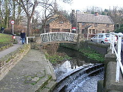
Thorpe Salvin is a village and a civil parish in the Metropolitan Borough of Rotherham in South Yorkshire, England, on the border with Nottinghamshire. It lies between Worksop and Harthill, and is located at an elevation of around 110 metres above sea level. At the 2011 Census, it had a population of 476, down from 502 in 2001.

Beighton —which includes the districts of Beighton, Hackenthorpe, Owlthorpe, and Sothall—is one of the 28 electoral wards in City of Sheffield, England. It is located in the eastern part of the city, on the border with Rotherham and covers an area of 5.7 km2. The population of this ward in 2011 was 17,939 people in 7,538 households.
Ecclesfield is a village and civil parish in the City of Sheffield, South Yorkshire, England, about 4 miles (6 km) north of Sheffield City Centre. Ecclesfield civil parish had a population of 32,073 at the 2011 Census. Ecclesfield wards of the City of Sheffield had a population of 35,994 in 2011. The population of Ecclesfield village stood at 7,163 in the most recent census.

Treeton is a village and civil parish of the Metropolitan Borough of Rotherham in South Yorkshire, England. It is located about 4 miles (6 km) south of the town of Rotherham and 5 miles (8 km) east of Sheffield City Centre.

Harworth is an area and former civil parish, now in the parish of Harworth Bircotes in the Bassetlaw district in Nottinghamshire, England, on the border with South Yorkshire. It is 8 miles (13 km) north of Worksop. The population of the civil parish of Harworth Bircotes was 7,948 in the 2011 Census.
Killamarsh is a village and civil parish in North East Derbyshire, England, bordering Rotherham to the north and Sheffield to the north-west.

Wickersley is a village and civil parish in the Metropolitan Borough of Rotherham in South Yorkshire, England, situated 3 miles (5 km) from the centre of Rotherham. The area is very near to road junctions for the M1, M18 and A1(M). It is home to the secondary school and sixth form, Wickersley School and Sports College.
Catcliffe is a village and civil parish on the north-west bank of the River Rother in South Yorkshire, England. The population of the civil parish at the 2011 census was 2,108. It is in the Metropolitan Borough of Rotherham, approximately 2.5 miles (4 km) south of the town of Rotherham and 4.3 miles (7 km) east of Sheffield City Centre.

Wentworth is a village and civil parish in the Metropolitan Borough of Rotherham in South Yorkshire, England.

Wortley is a village and civil parish in the Metropolitan Borough of Barnsley, South Yorkshire, England. At the 2001 census it had a population of 579, increasing to 626 at the 2011 Census. Wortley is mentioned in the 1086 Domesday Book as Wirtleie.

Danby Wiske is a village and the main settlement in the civil parish of Danby Wiske with Lazenby, in North Yorkshire, England. The village lies 3.7 miles (6 km) north north-west of the county town of Northallerton.

Brinsworth is a village and civil parish in the Metropolitan Borough of Rotherham, in South Yorkshire, England. It is situated close to the River Rother between Rotherham and Sheffield. At the time of the 2001 census it had a population of 8,950, reducing to 8,789 at the 2011 Census.

Thrybergh is a village and civil parish in the Metropolitan Borough of Rotherham in South Yorkshire, England, 3 miles (4.8 km) from Rotherham. It had a population of 4,327 in 2001, reducing to 4,058 at the 2011 Census.
Ulley is a village and civil parish of the Metropolitan Borough of Rotherham in South Yorkshire, England. The population of the civil parish as of the 2011 census was 172. It is located about 4 miles (6 km) south of the town of Rotherham and 7 miles (11 km) east of Sheffield City Centre.

Ravenfield is a small village and civil parish in South Yorkshire, England. It is located in the Metropolitan Borough of Rotherham, 3.3 miles (5.3 km) east of the town of Rotherham. The older part is a former farming village and over recent years has become a pretty rural community; it has been particularly successful in the Britain in Bloom competitions. It has a population of 2,018, increasing to 2,828 at the 2011 census.

Intake is a suburb and former village located 5 miles (8 km) south-east of Sheffield city centre, South Yorkshire, England. Due to expansion during the 20th century, the village became a part of the city of Sheffield. Intake is linked to Frecheville via Birley Moor Road, and to Gleadless via Hollinsend Road.

Rawmarsh is a large village in the Metropolitan Borough of Rotherham, in South Yorkshire, England. Historically within the West Riding of Yorkshire, it is 2 miles (3 km) north-northeast from Rotherham town centre and 3 miles (5 km) south-southwest of Swinton. The village also forms part of the Sheffield Urban Area. The Rawmarsh ward of Rotherham MBC had a population of 13,389 at the 2011 Census. Rawmarsh also contains other output areas from neighbouring wards giving it a population of 18,498 in 2011 and 18,535 in 2014.