Stonehenge is a prehistoric megalithic structure on Salisbury Plain in Wiltshire, England, two miles (3 km) west of Amesbury. It consists of an outer ring of vertical sarsen standing stones, each around 13 feet (4.0 m) high, seven feet (2.1 m) wide, and weighing around 25 tons, topped by connecting horizontal lintel stones. Inside is a ring of smaller bluestones. Inside these are free-standing trilithons, two bulkier vertical sarsens joined by one lintel. The whole monument, now ruinous, is aligned towards the sunrise on the summer solstice and sunset on the winter solstice. The stones are set within earthworks in the middle of the densest complex of Neolithic and Bronze Age monuments in England, including several hundred tumuli.

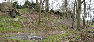
Uffington Castle is an early Iron Age univallate hillfort in Oxfordshire, England. It covers about 32,000 square metres and is surrounded by two earth banks separated by a ditch with an entrance in the western end. A second entrance in the eastern end was apparently blocked up a few centuries after it was built. The original defensive ditch was V-shaped with a small box rampart in front and a larger one behind it. Timber posts stood on the ramparts. Later the ditch was deepened and the extra material dumped on top of the ramparts to increase their size. A parapet wall of sarsen stones lined the top of the innermost rampart. It is very close to the Uffington White Horse on White Horse Hill.

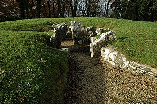
The West Kennet Long Barrow, also known as South Long Barrow, is a chambered long barrow near the village of Avebury in the south-western English county of Wiltshire. Probably constructed in the thirty-seventh century BC, during Britain's Early Neolithic period, today it survives in a partially reconstructed state.
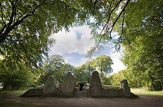
Long barrows are a style of monument constructed across Western Europe in the fifth and fourth millennia BCE, during the Early Neolithic period. Typically constructed from earth and either timber or stone, those using the latter material represent the oldest widespread tradition of stone construction in the world. Around 40,000 long barrows survive today.

The Thornborough Henges are an ancient monument complex that includes the three aligned henges that give the site its name. They are located on a raised plateau above the River Ure near the village of Thornborough in North Yorkshire, England. The site includes many large ancient structures including a cursus, henges, burial grounds and settlements.

The Medway Megaliths, sometimes termed the Kentish Megaliths, are a group of Early Neolithic chambered long barrows and other megalithic monuments located in the lower valley of the River Medway in Kent, South-East England. Constructed from local sarsen stone and soil between the 4th and 3rd millennia BCE, they represent the only known prehistoric megalithic group in eastern England and the most south-easterly group in Britain.

Winterbourne Gunner is a village and former civil parish, now in the parish of Winterbourne, in Wiltshire, England, about 4 miles (6 km) northeast of Salisbury. The village is near the River Bourne and the A338 road, and is close to Winterbourne Dauntsey. In 1931 the parish had a population of 292. On 1 April 1934, the parish was abolished and merged with Winterbourne Earls and Winterbourne Dauntsey to form Winterbourne parish.

The Stonehenge Landscape is a property of The National Trust, located on Salisbury Plain in Wiltshire, England. The estate covers 2,100 acres (850 ha) surrounding the neolithic monument of Stonehenge, which is administered by English Heritage. Much of the land is designated open access by the Trust, including the fields immediately around Stonehenge and other fields that become available as part of the chalk grassland reversion project. Stonehenge itself is in the care of English Heritage, having been given to the nation in 1918 by Cecil and Mary Chubb, who had bought it three years previously from the Antrobus family.
Robin Hood’s Ball is a Neolithic causewayed enclosure on Salisbury Plain in Wiltshire, England, approximately 5 miles (8 km) northwest of the town of Amesbury, and 2+1⁄2 miles (4.0 km) northwest of Stonehenge. The site was designated as a scheduled monument in 1965.
Stonehenge, Avebury and Associated Sites is a UNESCO World Heritage Site (WHS) in Wiltshire, England. The WHS covers two large areas of land separated by about 24 kilometres (15 mi), rather than a specific monument or building. The sites were inscribed as co-listings in 1986. Some large and well known monuments within the WHS are listed below, but the area also has an exceptionally high density of small-scale archaeological sites, particularly from the prehistoric period. More than 700 individual archaeological features have been identified. There are 160 separate scheduled monuments, covering 415 items or features.

Upton Lovell is a village and civil parish in Wiltshire, England. It lies on the A36, in the Wylye valley about 5 miles (8.0 km) southeast of Warminster. The parish is on the left (northeast) bank of the river, and stretches for over two miles northeast onto Salisbury Plain.

The Stoney Littleton Long Barrow is a Neolithic chambered tomb with multiple burial chambers, located near the village of Wellow in the English county of Somerset. It is an example of the Cotswold-Severn Group and was scheduled as an ancient monument in 1882. It was one of the initial monuments included when the Ancient Monuments Protection Act 1882 became law.
Vespasian's Camp is an Iron Age hillfort just west of the town of Amesbury, Wiltshire, England. The hillfort is less than 3 kilometres (2 mi) from the Neolithic and Bronze Age site of Stonehenge, and was built on a hill next to the Stonehenge Avenue; it has the River Avon on its southern side and the A303 road on its northern edge. The site is a scheduled monument and lies within the boundaries of the Stonehenge World Heritage Site.

The Wiltshire Museum, formerly known as Wiltshire Heritage Museum and Devizes Museum, is a museum, archive and library and art gallery established in 1874 in Devizes, Wiltshire, England. The museum was created and is run by the Wiltshire Archaeological and Natural History Society, a registered charity founded in 1853.
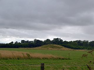
Normanton Down is a Neolithic and Bronze Age barrow cemetery, about 0.6 miles (1 km) south of Stonehenge in Wiltshire, England. The burials date from between 2600 and 1600 BC and consist of a Neolithic long barrow and some 40 or more Bronze Age round barrows, along the crest of a low ridge.

Marden Henge is the largest Neolithic henge enclosure discovered to date in the United Kingdom. The monument is north-east of the village of Marden, Wiltshire, within the Vale of Pewsey and between the World Heritage Sites of Avebury and Stonehenge.

Scratchbury Camp is the site of an Iron Age univallate hillfort on Scratchbury Hill, overlooking the Wylye valley about 1 km northeast of the village of Norton Bavant in Wiltshire, England. The fort covers an area of 37 acres (15 ha) and occupies the summit of the hill on the edge of Salisbury Plain, with its four-sided shape largely following the natural contours of the hill.
51.71025°N 2.29970°W

Adam's Grave was a Neolithic long barrow near Alton Barnes in Wiltshire, southwest England. Its remains have been scheduled as an ancient monument.

Barrow Clump is an archaeological site in Figheldean parish, Wiltshire, England, about 3+1⁄2 miles (5.6 km) north of the town of Amesbury. The site is a scheduled monument.