White Castle, Monmouthshire

Last updated

White Castle
Monmouthshire, Wales
White Castle, Cadw image.jpg
Gatehouse and curtain wall of the inner ward, seen from the outer ward
Monmouthshire UK location map.svg
Red pog.svg
White Castle
Coordinates 51°50′43″N2°54′10″W / 51.8454°N 2.9029°W / 51.8454; -2.9029
Site information
Controlled by Cadw
Open to
the public
Yes
ConditionRuined
Site history
MaterialsRed sandstone
Events Norman invasion of Wales
Listed Building – Grade I

White Castle (Welsh : Castell Gwyn), also known historically as Llantilio Castle, is a ruined castle near the village of Llantilio Crossenny in Monmouthshire, Wales. The fortification was established by the Normans in the wake of the invasion of England in 1066, to protect the route from Wales to Hereford. Possibly commissioned by William fitz Osbern, the Earl of Hereford, it comprised three large earthworks with timber defences. In 1135, a major Welsh revolt took place and in response King Stephen brought together White Castle and its sister fortifications of Grosmont and Skenfrith to form a lordship known as the "Three Castles", which continued to play a role in defending the region from Welsh attack for several centuries.

Contents

King John gave the castle to a powerful royal official, Hubert de Burgh, in 1201. Over the next few decades, it passed back and forth between several owners, as Hubert, the rival de Braose family, and the Crown took control of the property. During this period, White Castle was substantially rebuilt, with stone curtain walls, mural towers and gatehouses, forming what the historian Paul Remfry considers to be "a masterpiece of military engineering". [1] In 1267 it was granted to Edmund, the Earl of Lancaster, and remained in the hands of the earldom, and later duchy, of Lancaster until 1825.

Edward I's conquest of Wales in 1282 removed much of White Castle's military utility, and by the 16th century it had fallen into disuse and ruin. The castle was placed into the care of the state in 1922, and is now managed by Cadw, the Welsh heritage agency.

History

11th–12th centuries

White Castle was built in the wake of the Norman invasion of England in 1066. [2] Shortly after the invasion, the Normans pushed into the Welsh Marches, where William the Conqueror made William fitz Osbern the Earl of Hereford; Earl William added to his new lands by capturing the towns of Monmouth and Chepstow. [3] The Normans used castles extensively to subdue the Welsh, establish new settlements and exert their claims of lordship over the territories. [4]

The outer ward's gatehouse The ruins of White Castle on a gloomy October day - geograph.org.uk - 1007095.jpg
The outer ward's gatehouse

Originally called Llantilio Castle, White Castle was one of three fortifications built in the Monnow valley around the same time, possibly by Earl William himself, to protect the route from Wales to Hereford, and overlooked the manor of Llantilio Crossenny and the River Monnow. [5] The first castle on the site was built from earth and timber, with three large earthworks forming an inner and outer ward, and a hornwork protecting the main entrance to the south. [6] A mill was constructed at Great Trerhew to grind corn for the castle garrison. [7]

The earldom's landholdings in the region were slowly broken up after William's son, Roger de Breteuil, rebelled against the Crown in 1075. [8] In 1135, a major Welsh revolt took place, and in response King Stephen restructured the landholdings along this section of the Marches, bringing White Castle and its sister fortifications of Grosmont and Skenfrith back under the control of the Crown to form a lordship known as the "Three Castles". [8]

Conflict with the Welsh continued, and following a period of detente under Henry II in the 1160s, the de Mortimer and de Braose Marcher families attacked their Welsh rivals during the 1170s, leading to a Welsh assault on nearby Abergavenny Castle in 1182. [9] In response, the Crown readied the castle to face an attack and, between 1184 and 1186, work costing £128 [nb 1] was carried out by Ralph of Grosmont, a royal official, probably to build a stone curtain wall around the inner ward and to add a small stone keep to the defences. [11]

13th–17th centuries

The castle's unusual arrow loops White Castle, arrow slit.jpg
The castle's unusual arrow loops

In 1201, King John gave the Three Castles to Hubert de Burgh. [12] Hubert was a minor landowner who had become John's household chamberlain when he was still a prince, and went on to become an increasingly powerful royal official once John inherited the throne. [13] At this time, White Castle was primarily a military fortification, holding a garrison and stores of arrows and crossbow bolts. [14] It was relatively exposed to the elements and had, at best, only basic accommodation; the historian Cathcart King describes the conditions in the castle as likely to have been "miserable", "squalid" and "unpleasant". [15]

Hubert began to upgrade his new castles, starting with Grosmont, but was captured while fighting in France. [12] During Hubert's captivity, King John took back the Three Castles and gave them to William de Braose, a rival of Hubert's. [13] King John subsequently fell out with William and dispossessed him of his lands in 1207, but de Braose's son, also called William, took the opportunity presented by the First Barons' War to retake the castles. [16]

Once released, Hubert regained his grip on power, becoming the royal justiciar and being made the Earl of Kent, before finally recovering the Three Castles in 1219 during the reign of King Henry III. [16] Hubert fell from power in 1232 and was stripped of the castles, which were placed under the command of Walerund Teutonicus, a royal servant; having been reconciled with the King in 1234, the castles were briefly returned to Hubert, but he fell out with King Henry III again in 1239 and they were taken back and assigned to Walerund. [17] Walerund built a new hall, buttery and pantry at the castle in 1244. [18] In 1254, White Castle and its sister fortifications were granted to King Henry's eldest son, and later King, Prince Edward. [18]

The interior of the inner ward White Castle, inner ward.JPG
The interior of the inner ward

During the 13th century, the castle was almost entirely rebuilt, although historians have put forward two possible timelines for when this work was carried out. [6] The conventional historical dating places the construction in the 1250s and 1260s, as a single programme of work consisting in the keep being demolished, a new gatehouse and four mural towers constructed and the outer ward reinforced with a stone wall and gatehouse of its own. [19] Paul Remfry argues that the work occurred somewhat earlier during Hubert's tenure, being carried out in two waves between 1229–1231 and 1234–1239. [1] Around this time the fortification is first described in the records as the "White Castle", due to the white rendering applied to its external walls. [6]

The Welsh threat persisted, and in 1262 the castle was readied in response to Prince Llywelyn ap Gruffudd's attack on Abergavenny in 1262; commanded by its constable Gilbert Talbot, Grosmont was ordered to be garrisoned "by every man, and at whatever cost". [18] The threat passed without incident. [18]

Edmund, the Earl of Lancaster and the capitaneus of the royal forces in Wales, was given the Three Castles in 1267 and for many centuries they were held by the earldom, later duchy, of Lancaster. [20] King Edward I's conquest of Wales in 1282 removed much of White Castle's military utility, although it continued to be used in the administration of the surrounding manor, and for mustering military levies. [21] Little further work was carried out on the fortification, although one of the gatehouse towers was repaired at some point, and repairs were carried out to the chapel tower and gatehouse under King Henry VI. [22] By 1538, White Castle had fallen into disuse and then into ruin; a 1613 description noted that it was "ruynous and decayed". [22]

18th–21st centuries

In 1825, the Three Castles were sold off to Henry Somerset, the Duke of Beaufort. [23] In 1902, Henry Somerset, the 9th Duke, sold White Castle to Sir Henry Mather Jackson. [23] Evidence was given to the Royal Commission on Ancient Monuments in Wales and Monmouthshire in 1909, stating that Sir Henry had taken steps to strip the castle of ivy and that it was now in a good condition; the site was apparently looked after by an old woman, who charged visitors for entry. [24] The castle was placed into the care of the state in 1922. [23] In the 21st century, White Castle is managed by the Welsh heritage agency Cadw and is protected under UK law as a grade I listed building. [25]

Architecture

Plan of the castle: A - outer ward; B - outer gatehouse; C - moat; D- inner ward; E - former location of outer enclosure; F - hornwork White Castle plan labelled.png
Plan of the castle: A – outer ward; B – outer gatehouse; C – moat; D- inner ward; E – former location of outer enclosure; F – hornwork

White Castle occupies a hill near the village of Llantilio Crossenny, overlooking the surrounding landscape. [26] The castle dates mainly from the 13th century and is made up of a central inner ward, a crescent-shaped hornwork to the south, and an outer ward to the north, with its stonework constructed from red sandstone. [27] The outer ward was originally much larger, extending around the castle further to the east, but only limited traces of these earthworks survive. [6] It is now entered from the north-east although, before the 13th century, the entrance was originally on the south side. [6] The historian Paul Remfry considers the castle to be "a masterpiece of military engineering" for the period. [1]

The outer ward is 320 by 170 feet (98 by 52 m) across, accessed by a gatehouse on the eastern edge and defended by a stone curtain wall, a dry ditch and four mural towers. [28] The gatehouse, which survives up to 5 metres (16 ft) in height, originally had a portcullis and a drawbridge. [29] Three of the towers were circular in design, but one was rectangular and would have been used as lodgings for a household official. [30] There was a large building, probably a barn, 115 by 66 feet (35 by 20 m) across, on the north-western edge of the ward, alongside a group of smaller buildings, but all have since been lost. [30]

The inner ward is approximately 150 by 110 feet (46 by 34 m) across, protected by a deep, revetted, water-filled moat, dug out of the rock. [31] The curtain wall has four circular, four-storey towers and a gatehouse, with domestic buildings reaching around the insides of the defences. [32] The four-storey gatehouse is flanked by two circular towers and would originally have had a portcullis and a drawbridge. [33] It would originally have been used by the castle's constable or steward. [34] Stretching eastwards from the gatehouse are the castle's hall, the constable's living quarters, the chapel – partially contained in one of the towers- the remains of the earlier keep, service buildings and the kitchen block. [35] Only the foundations of these buildings survive. [36] A postern gate in the inner ward leads through to the southern hornwork, which would originally have been linked by a wooden bridge, protected by timber defences and towers, with later stone additions, of which only traces remain. [37]

White Castle has unusual arrow loops, with the two arms of a conventional cross-shaped loop offset vertically, so that one side is higher than the other. [38] Historians have contrasting views of the effectiveness of this design; they might have been a sensible way to ensure that the defenders could shoot down the slopes around the castle, or to give better protection from incoming shot, although tests in 1980 showed them to have been extremely vulnerable to incoming shots. [39]

See also

Notes

  1. Comparison of medieval financial figures with modern equivalents is challenging. For comparison, the average annual income of a baron during this period was around £200. [10]

Related Research Articles

<span class="mw-page-title-main">Criccieth Castle</span> 13th-century castle in Criccieth, Gwynedd, Wales

Criccieth Castle is a ruined thirteenth-century castle in Criccieth, Gwynedd, Wales. It is located on a rocky headland overlooking Tremadog Bay and consists of an inner ward almost surrounded by an outer ward. The twin-towered inner gatehouse is the most prominent remaining feature and survives to almost its full height, as does the inner curtain wall. The outer curtain wall, the inner ward buildings, and the castle's other three towers are significantly more ruinous, and in places survive only as foundations.

<span class="mw-page-title-main">Caerphilly Castle</span> Castle in Caerphilly, Wales

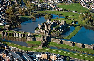
Caerphilly Castle is a medieval fortification in Caerphilly in South Wales. The castle was constructed by Gilbert de Clare in the 13th century as part of his campaign to maintain control of Glamorgan, and saw extensive fighting between Gilbert, his descendants, and the native Welsh rulers. Surrounded by extensive artificial lakes – considered by historian Allen Brown to be "the most elaborate water defences in all Britain" – it occupies around 30 acres (12 ha) and is the largest castle in Wales and the second-largest castle in the United Kingdom after Windsor Castle. It is famous for having introduced concentric castle defences to Britain and for its large gatehouses. Gilbert began work on the castle in 1268 following his occupation of the north of Glamorgan, with the majority of the construction occurring over the next three years at a considerable cost. The project was opposed by Gilbert's Welsh rival Llywelyn ap Gruffudd, leading to the site being burnt in 1270 and taken over by royal officials in 1271. Despite these interruptions, Gilbert successfully completed the castle and took control of the region. The core of Caerphilly Castle, including the castle's luxurious accommodation, was built on what became a central island, surrounding by several artificial lakes, a design Gilbert probably derived from that at Kenilworth. The dams for these lakes were further fortified, and an island to the west provided additional protection. The concentric rings of walls inspired Edward I's castles in North Wales, and proved what historian Norman Pounds has termed "a turning point in the history of the castle in Britain".

<span class="mw-page-title-main">Chepstow Castle</span> Castle in Chepstow, Monmouthshire, Wales

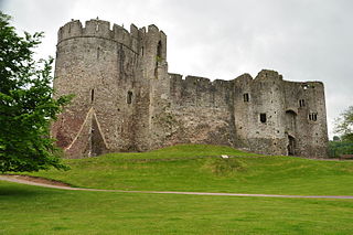
Chepstow Castle at Chepstow, Monmouthshire, Wales is the oldest surviving post-Roman stone fortification in Britain. Located above cliffs on the River Wye, construction began in 1067 under the instruction of the Norman Lord William FitzOsbern. Originally known as Striguil, it was the southernmost of a chain of castles built in the Welsh Marches, and with its attached lordship took the name of the adjoining market town in about the 14th century.

<span class="mw-page-title-main">Carreg Cennen Castle</span> Castle in Carmarthenshire, Wales, United Kingdom

Carreg Cennen Castle is a castle sited on a high rocky outcrop overlooking the River Cennen, close to the village of Trap, four miles south east of Llandeilo in Carmarthenshire, Wales. Castell Carreg Cennen means castle on a rock next to Cennen, the river name itself being a reference either to cen meaning lichen or perhaps a personal name.

<span class="mw-page-title-main">Skenfrith Castle</span> Ruined castle in the village of Skenfrith in Monmouthshire, Wales

Skenfrith Castle is a ruined castle in the village of Skenfrith in Monmouthshire, Wales. The fortification was established by the Normans in the wake of the invasion of England in 1066, to protect the route from Wales to Hereford. Possibly commissioned by William fitz Osbern, the Earl of Hereford, the castle comprised earthworks with timber defences. In 1135, a major Welsh revolt took place and in response King Stephen brought together Skenfrith Castle and its sister fortifications of Grosmont and White Castle to form a lordship known as the "Three Castles", which continued to play a role in defending the region from Welsh attack for several centuries.

<span class="mw-page-title-main">Denbigh Castle and town walls</span> Ruined castle and fortifications in Denbigh, Wales

Denbigh Castle and town walls were built to control the lordship of Denbigh after the Conquest of Wales by Edward I of England in 1282. The lands were granted to Henry de Lacy, Earl of Lincoln, who began to build a new walled town, colonised by immigrants from England, protected by a substantial castle and surrounded by deer parks for hunting. The work had not been completed by 1294, when the Welsh temporarily seized the castle during the Madog ap Llywelyn revolt. The defences continued to be improved, although the castle was not completely finished by the time of Henry's death in 1311.

<span class="mw-page-title-main">Abergavenny Castle</span> Ruined castle in Abergavenny, Monmouthshire, Wales

Abergavenny Castle is a ruined castle in the market town of Abergavenny, Monmouthshire, Wales, established by the Norman lord Hamelin de Balun c. 1087. It was the site of a massacre of Welsh noblemen in 1175, and was attacked during the early 15th-century Glyndŵr Rising. William Camden, the 16th-century antiquary, said that the castle "has been oftner stain'd with the infamy of treachery, than any other castle in Wales."

<span class="mw-page-title-main">Grosmont, Monmouthshire</span> Human settlement in Wales

Grosmont is a village and community near Abergavenny in Monmouthshire, Wales. The population taken at the 2011 census was 920. The wider community (parish) includes the villages of Llangattock Lingoed, Llangua and Llanvetherine.

<span class="mw-page-title-main">Grosmont Castle</span> Castle ruins in Monmouthshire, Wales

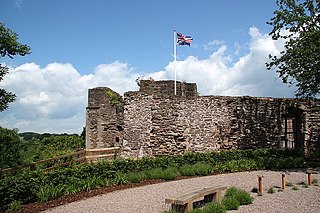
Grosmont Castle is a ruined castle in the village of Grosmont, Monmouthshire, Wales. The fortification was established by the Normans in the wake of the invasion of England in 1066, to protect the route from Wales to Hereford. Possibly commissioned by William fitz Osbern, the Earl of Hereford, it was originally an earthwork design with timber defences. In 1135, a major Welsh revolt took place, and in response King Stephen brought together Grosmont Castle and its sister fortifications of Skenfrith and White Castle to form a lordship known as the "Three Castles", which continued to play a role in defending the region from Welsh attack for several centuries.

<span class="mw-page-title-main">Montgomery Castle</span> Grade I listed building in Powys, Wales

Montgomery Castle is a stone-built castle looking over the town of Montgomery in Powys, Mid Wales. It is one of many Norman castles on the border between Wales and England.

<span class="mw-page-title-main">Castell Dinas</span> Castle in Powys, Wales

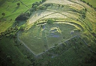
Castell Dinas is a hillfort and castle in southern Powys, Wales. At 450 m (SO179301) it has the highest castle in England and Wales. It is positioned to defend the Rhiangoll pass between Talgarth and Crickhowell.

<span class="mw-page-title-main">Llantilio Crossenny</span> Human settlement in Wales

Llantilio Crossenny is a small village and much larger former community, now in the community of Whitecastle, in Monmouthshire, south east Wales, in the United Kingdom. It is situated between the two towns of Abergavenny and Monmouth on the B4233 road. The community included Penrhos, and Llanvihangel-Ystern-Llewern.

<span class="mw-page-title-main">Monmouth Castle</span>

Monmouth Castle is a castle close to the centre of the town of Monmouth, the county town of Monmouthshire, on a hill above the River Monnow in south-east Wales.

<span class="mw-page-title-main">St Quintins Castle</span> Ruined castle in Llanblethian, Wales

St Quintins Castle is a castle located in the village of Llanblethian, Cowbridge, Wales. It is a scheduled monument and a Grade II* listed building and is under the care of Cadw. The site was first occupied with a defensive structure in about 1102 and the gatehouse and further building work took place around 1312. It was later used as a prison and was reported as being in a ruinous state by 1741.

<span class="mw-page-title-main">Church of St Nicholas, Grosmont</span> Church in Monmouthshire, Wales

The Church of St Nicholas in the village of Grosmont, Monmouthshire, Wales, is a parish church dating from the 13th century. Its exceptional size reflects the importance and standing of the borough of Grosmont at the time of the church's construction and has led it to be called a "miniature cathedral". Largely unaltered from the time of its building, by the 19th century the church had seriously decayed and its tower was close to collapse. It was rescued from dereliction in a restoration undertaken by John Pollard Seddon and financed by John Etherington Welch Rolls.

<span class="mw-page-title-main">St Teilo's Church, Llantilio Crossenny</span> Church in Monmouthshire, Wales

The Church of St Teilo is the parish church of Llantilio Crossenny, Monmouthshire, Wales. "An unusually grand cruciform church", with an Early English tower crossed by a Decorated chancel, it was designated a Grade I listed building on 19 November 1953

<span class="mw-page-title-main">Grade I listed buildings in Monmouthshire</span>

Monmouthshire is a county and principal area of Wales. It borders Torfaen and Newport to the west; Herefordshire and Gloucestershire to the east; and Powys to the north. The largest town is Abergavenny, with the other major towns being Chepstow, Monmouth, and Usk. The county is 850 km2 in extent, with a population of 95,200 as of 2020. The present county was formed under the Local Government (Wales) Act 1994, which came into effect in 1996, and comprises some sixty percent of the historic county. Between 1974 and 1996, the county was known by the ancient title of Gwent, recalling the medieval Welsh kingdom. In his essay on local government in the fifth and final volume of the Gwent County History, Robert McCloy suggests that the governance of "no county in the United Kingdom in the twentieth century was so transformed as that of Monmouthshire".

<span class="mw-page-title-main">Hen Gwrt Moated Site</span> Site in Llantilio Crossenny, Monmouthshire

Hen Gwrt,, Llantilio Crossenny, Monmouthshire is the site of a thirteenth century manor house and a sixteenth century hunting lodge. Originally constructed for the Bishops of Llandaff, it subsequently came into the possession of the Herberts of Raglan Castle. The bishops constructed a substantial manor house on the site in the thirteenth century, which was moated in the fourteenth. The building was then adapted by the Herberts to create a lodge within their extensive hunting grounds. The lodge continued in use until the slighting of Raglan Castle in the English Civil War.

The Three Castles was a former medieval lordship, comprising the fortifications of Grosmont, Skenfrith and White Castle in Monmouthshire, Wales. The castles were established by the Normans in the wake of their conquest of England in 1066, to protect the route from Wales to Hereford. Possibly commissioned by William fitz Osbern, the Earl of Hereford, they initially comprised earthwork fortifications with timber defences. In 1135, a major Welsh revolt took place and in response King Stephen brought the castles together to form the lordship, which continued to play a role in defending the region for several centuries.

<span class="mw-page-title-main">Registered historic parks and gardens in Monmouthshire</span> List of buildings in the county of Wales

Monmouthshire is a county of Wales. It borders Torfaen and Newport to the west; Herefordshire and Gloucestershire to the east; and Powys to the north. The largest town is Abergavenny, with other large settlements being Chepstow, Monmouth, and Usk. The present county was formed under the Local Government (Wales) Act 1994, which came into effect in 1996. It has an area of 850 km2 (330 sq mi), with a population of 93,200 as of 2021. Monmouthshire comprises some sixty per cent of the historic county, and was known as Gwent between 1974 and 1996.

References

  1. 1 2 3 Remfry 2010–2011 , p. 226
  2. Knight 2009 , pp. 3–4
  3. Knight 2009 , p. 3
  4. Davies 2006 , pp. 41–44
  5. Radford 1962 , p. 3; Knight 2009 , p. 4
  6. 1 2 3 4 5 Knight 2009 , p. 37
  7. "Smaller Projects", Village Alive Trust, retrieved 24 September 2017
  8. 1 2 Knight 2009 , p. 4
  9. Knight 2009 , p. 5; Holden 2008 , p. 143
  10. Pounds 1994, p. 147
  11. Knight 2009 , p. 5
  12. 1 2 Knight 2009 , p. 7
  13. 1 2 Knight 2009 , p. 7; West, F. J. (2008), "Burgh, Hubert de, earl of Kent (c.1170–1243), justiciar" , Oxford Dictionary of National Biography (Online ed.), Oxford University Press, doi:10.1093/ref:odnb/3991 (Subscription or UK public library membership required.)
  14. Knight 2009 , pp. 8–9
  15. King 1991 , pp. 11–12
  16. 1 2 Radford 1962 , p. 4; Knight 2009 , p. 7
  17. Knight 2009 , pp. 10–11
  18. 1 2 3 4 Knight 2009 , p. 11
  19. Knight 2009 , p. 12; Remfry 2010–2011 , p. 226; Taylor 1961 , p. 175; Goodall 2011 , p. 183; "Scheduled Monuments- Full Report", Cadw, retrieved 22 October 2017
  20. Knight 2009 , p. 12; Taylor 1961 , p. 174
  21. Radford 1962 , p. 6
  22. 1 2 Knight 2009 , p. 14
  23. 1 2 3 Knight 2009 , p. 15
  24. Royal Commission on Ancient Monuments in Wales and Monmouthshire 1912 , pp. 60–61
  25. Cadw, "Scheduled Monuments- Full Report", Listed Buildings, retrieved 24 October 2017
  26. Knight 2009 , p. 37; Cadw, "Scheduled Monuments- Full Report", Listed Buildings, retrieved 24 October 2017
  27. Knight 2009 , p. 37; Cadw, "Scheduled Monuments- Full Report", Listed Buildings, retrieved 24 October 2017
  28. Knight 2009 , pp. 37–38; Radford 1962 , p. 11
  29. Knight 2009 , p. 38; Cadw, "Scheduled Monuments- Full Report", Listed Buildings, retrieved 24 October 2017
  30. 1 2 Knight 2009 , p. 39
  31. Knight 2009 , p. 40; Radford 1962 , p. 7; Cadw, "Scheduled Monuments- Full Report", Listed Buildings, retrieved 24 October 2017
  32. Knight 2009 , pp. 42–44
  33. Knight 2009 , pp. 40–41
  34. Knight 2009 , p. 42
  35. Knight 2009 , pp. 42–45
  36. Knight 2009 , pp. 42–43; Pounds 1994 , p. 240
  37. Knight 2009 , pp. 44–45
  38. Knight 2009 , p. 43
  39. Knight 2009 , p. 39; Liddiard 2005 , p. 51; Goodall 2011 , pp. 45–46

Bibliography