In 1826, Tenskwatawa established a village at a site in modern Kansas City, Kansas. Tensquatawa, known as the Shawnee Prophet, was the younger brother of the Shawneewar chief, Tecumseh. Tensquatawa built Prophetstown near the present South 26th Street and Woodend Avenue[2] in Kansas City, Kansas. He later moved from there to White Feather Spring. He died here in November 1836 (located in the Argentine, Kansas; the White Feather Spring marker notes the location[3]).
The grave of the Prophet, about seventy-five or a hundred yards to the northwest of his home, was not marked for around sixty years. An editor of the Kansas City Sun, E. F. Heisler, in 1897 went to the Indian Territory and got Charles Bluejacket, who had been present at the Prophet's burial when he was 20 yrs. old, to locate the grave. He located the natural spring, that still flows today, where the Prophets home was and told those present where the Prophet's grave was. A temporary marker was placed but later removed. No permanent marker was put down and the exact grave location today is not known.
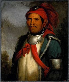
Ten-sqúat-a-way, painted by George CatlanTenskwatawa
Miami County is a county located in east-central Kansas and is part of the Kansas City metropolitan area. As of the 2020 census, the county population was 34,191. Its county seat and most populous city is Paola.
Johnson County is a county in the U.S. state of Kansas, on the border with Missouri. As of the 2020 census, the population was 609,863, making it the most populous county in Kansas. Its county seat is Olathe. Largely suburban, the county contains a number of suburbs of Kansas City, Missouri, including Overland Park, the second most populous city in the Kansas City Metropolitan Area. The county is home to the headquarters of Garmin and AMC Theatres.
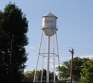
De Soto is a city in Johnson and Leavenworth counties in the U.S. state of Kansas, and part of the Kansas City Metropolitan Area. As of the 2020 census, the population of the city was 6,118. De Soto was incorporated as a city on October 1, 1897.
Kansas City, abbreviated as "KCK", is the third-largest city in the U.S. state of Kansas, the county seat of Wyandotte County, and the third-largest city of the Kansas City metropolitan area. As of the 2020 census, the population of the city was 156,607. The city formed as a streetcar suburb of Kansas City, Missouri, after which it is named. It is situated at Kaw Point, the junction of the Missouri and Kansas rivers. It is part of a consolidated city-county government known as the "Unified Government". Wyandotte County also includes the independent cities of Bonner Springs, Edwardsville, a portion of Lake Quivira, and the unincorporated area known as Loring.
Bonner Springs is a city in Wyandotte, Leavenworth, and Johnson counties, Kansas, United States. It is part of the Kansas City Metropolitan Area. As of the 2020 census, the population of the city was 7,837. Bonner Springs was incorporated as a city on November 10, 1898. Bonner Springs is home to the Azura Amphitheater, the National Agricultural Center and Hall of Fame, Wyandotte County Historical Museum, and the annual Kansas City Renaissance Festival.
The Shawnee are an Algonquian-speaking indigenous people of the Northeastern Woodlands. In the 17th century they lived in Pennsylvania, and in the 18th century they were in Pennsylvania, Ohio, and Indiana with some bands in Kentucky and Alabama. By the 19th century they were forcibly removed to Missouri, Kansas, Texas, and ultimately Indian Territory, which became Oklahoma under the 1830 Indian Removal Act.
Tenskwatawa was a Native American religious and political leader of the Shawnee tribe, known as the Prophet or the Shawnee Prophet. He was a younger brother of Tecumseh, a leader of the Shawnee. In his early years Tenskwatawa was given the name Lalawethika, but he changed it around 1805 and transformed himself from a hapless, alcoholic youth into an influential spiritual leader. Tenskwatawa denounced the Americans, calling them the offspring of the Evil Spirit, and led a purification movement that promoted unity among the Indigenous peoples of North America, rejected acculturation to the American way of life, and encouraged his followers to pursue traditional ways.
Turner is a neighborhood within Kansas City, Kansas, United States. It was formerly an unincorporated community of Wyandotte County, similar to Piper, Kansas. Turner has its own school district, Turner USD #202.
Kirkwood is a national historic designated neighborhood on the east side of Atlanta, Georgia, United States. It is a historic streetcar suburb, and was designed by architect Will Saunders. Kirkwood is situated entirely in DeKalb County, bordered by the neighborhoods of Lake Claire, East Lake, Edgewood, and Oakhurst. Kirkwood is bound on the north by DeKalb Avenue, on the south by Memorial Drive and Interstate 20, on the west by Montgomery Street, and on the east by 1st Ave. A large part of the neighborhood is listed on the National Register of Historic Places as Kirkwood Historic District.
Banfield is a city in the district of Lomas de Zamora in Buenos Aires Province, Argentina, 14 km (9 mi) south of the city center of Buenos Aires. It forms part of the Greater Buenos Aires metro area.
Argentine is a community of Kansas City, Kansas, located in the southern part of Wyandotte County. It is bordered on the west by the Turner community, on the east by the Rosedale community, on the south by Johnson County, and on the north by Armourdale community and by the Kansas River.
Shawnee Methodist Mission is also referred to as the Shawnee Mission today but is most appropriately called the Shawnee Indian Manual Labor Boarding School. In July 1830, Shawnee Tribal leadership formally requested that the US government make arrangements to establish a mission on tribal lands for childhood education. Day schools were then established by several Christian denominations, with the first Methodist school established by missionaries in 1830 in Turner, Kansas to educate children of the Shawnee tribe of Native Americans who had been removed to Kansas.
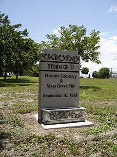
The Hurricane of 1928 African-American Mass Burial Site is a pauper's cemetery and mass grave in West Palm Beach, Florida. It is listed on the U.S. National Register of Historic Places. The cemetery is situated near the junction of 25th Street and Tamarind Avenue between I-95 and U.S. Route 1. The site is the location in which 674 bodies of African Americans or those of an unknown race were buried following the 1928 Okeechobee hurricane, while most of the white victims of the storm received a proper burial at Woodlawn Cemetery due to segregation laws.
De Soto High School is a public secondary school in De Soto, Kansas, United States, operated by De Soto USD 232 public school district, and serves students of grades 9 to 12. The school is located near highway K-10 and Lexington Avenue on 91st Street. Around 900 students in grades 9–12 attend DHS.
The boundary markers of the original District of Columbia are the 40 milestones that marked the four lines forming the boundaries between the states of Maryland and Virginia and the square of 100 square miles (259 km2) of federal territory that became the District of Columbia in 1801. Working under the supervision of three commissioners that President George Washington had appointed in 1790 in accordance with the federal Residence Act, a surveying team that Major Andrew Ellicott led placed these markers in 1791 and 1792. Among Ellicott's assistants were his brothers Joseph and Benjamin Ellicott, Isaac Roberdeau, George Fenwick, Isaac Briggs and an African American astronomer, Benjamin Banneker.
K-58 is a 46.761-mile-long (75.255 km) east–west state highway in the U.S. state of Kansas. K-58's western terminus is at K-99 west of Madison. It runs east through Lamont and Gridley and after a short concurrency with US-75, it goes through LeRoy before ending at the eastern terminus at U.S. Route 169 (US-169) near Colony. It is one of the newer state highways in Kansas formed on September 20, 2004, when K-57 was truncated at K-4 in Dwight. The route changes were made because of K-57's long concurrencies with K-4, K-177, US-50 and K-99.
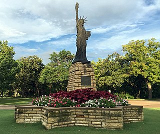
Strengthen the Arm of Liberty is the theme of the Boy Scouts of America's fortieth anniversary celebration in 1950. The campaign was inaugurated in February with a dramatic ceremony held at the base of the Statue of Liberty. Approximately 200 BSA Statue of Liberty replicas were installed across the United States.
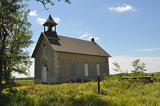
In the late 19th and the first half of the 20th century, one room schools were commonplace throughout rural Kansas. In most rural schools, all of the students met in a single room. One room meant one teacher who taught basic reading, writing, and arithmetic to both boys and girls of all grades. When one-on-one instruction was necessary, the teacher would call a student forward to the recitation desk.
Chief Wapello's Memorial Park, also known as Chief Wapello's Gravesite and the Site of Sac and Fox Indian Agency, is a historic site located near Agency, Iowa, United States. The property was listed on the National Register of Historic Places in 1975. The park is on the site of the Indian Agency that became the home of the Sauk and Meskwaki (Fox) tribes. They were relocated here by the United States government after the Black Hawk War of 1832. General Joseph M. Street was appointed the Indian Agent and settled with his family on the agency. He earned the respect of the Meskwaki chief Wapello. A stone marker marks the site of the Agency House. Another stone marker commemorates the 1842 negotiations for the tribes to hand over their Iowa lands to the United States government, and the first Christian services that were held in Iowa's interior by the Reverend Thomas Kirkpatrick, a Methodist Circuit Rider, in 1838. The tribes were relocated from here to Kansas.
This page is based on this Wikipedia article Text is available under the CC BY-SA 4.0 license; additional terms may apply. Images, videos and audio are available under their respective licenses.