Related Research Articles

Apache County is located in the northeast corner of the U.S. state of Arizona. Shaped in a long rectangle running north to south, as of the 2010 census its population was 71,518. The county seat is St. Johns.

Navajo County is located in the northern part of the U.S. state of Arizona. As of the 2010 census, its population was 107,449. The county seat is Holbrook.
Fort Defiance is a census-designated place (CDP) in Apache County, Arizona, United States. It is also located within the Navajo Nation. The population was 3,624 at the 2010 census.

McNary is a census-designated place (CDP) in Apache and Navajo counties in the U.S. state of Arizona, on the Fort Apache Indian Reservation. The population was 528 at the 2010 census. It is a 30-minute drive from Show Low and a 10-minute drive from Pinetop-Lakeside.

Round Rock is a Navajo community and census-designated place (CDP) in Apache County, Arizona, United States. The population was 789 at the 2010 census. It is named after a nearby mesa.
St. Johns is the county seat of Apache County, Arizona, United States. It is located along U.S. Route 180, mostly west of where that highway intersects with U.S. Route 191. As of the 2010 census, the population of the city was 3,480.

Tsaile is a census-designated place (CDP) in Apache County, Arizona, United States, on the Navajo Nation. The population was 1,205 at the 2010 census.

Cibecue is a census-designated place (CDP) in Navajo County, Arizona, United States, on the Fort Apache Indian Reservation. The population was 1,713 in the 2010 United States Census.
East Fork is a census-designated place (CDP) in Navajo County, Arizona, United States, on the Fort Apache Indian Reservation. The population was 699 at the 2010 census.

Whiteriver is a census-designated place (CDP) located on the Fort Apache Indian Reservation in Navajo County, Arizona, United States. The population was 4,104 at the 2010 census, making it the largest settlement on the Reservation.

Northern Arizona is an unofficial, colloquially-defined region of the U.S. state of Arizona. Generally consisting of Apache, Coconino, Mohave, Navajo, and Gila counties, the region is geographically dominated by the Colorado Plateau, the southern border of which in Arizona is called the Mogollon Rim.

The Fort Apache Indian Reservation is an Indian reservation in northeastern Arizona, United States, encompassing parts of Navajo, Gila, and Apache counties. It is home to the federally recognized White Mountain Apache Tribe of the Fort Apache Reservation, a Western Apache tribe. It has a land area of 1.6 million acres and a population of 12,429 people as of the 2000 census. The largest community is in Whiteriver.
Chinle Unified School District No. 24 (CUSD) is a public unified school district headquartered in Chinle, a census-designated place in Apache County, Arizona, on the Navajo Nation, United States. It is managed by a five-member elected school board, each of whom is Navajo, and operates by state rules. As of 2020, nearly all of the district's 3600 students are Navajo.
Alchesay High School is a public high school on the Fort Apache Indian Reservation in Whiteriver, Arizona, Navajo County. It was founded in 1956 and named after Chief Alchesay, who was a key person in the formation of the White Mountain Apache tribe. The first graduating class graduated in 1960.
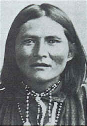
Alchesay was a chief of the White Mountain Apache tribe and an Indian Scout. He received the United States military's highest decoration for bravery, the Medal of Honor, for his actions during the Indian Wars.

Sanders is a census-designated place (CDP) in Apache County, Arizona, United States. Sanders is located at the junction of U.S. Route 191 and Interstate 40. As of the 2010 census, it had a population of 630.

Fort Apache is an unincorporated community in Navajo County, Arizona, United States. Fort Apache is on the Fort Apache Indian Reservation, 2 miles (3.2 km) east of Canyon Day. Fort Apache has a post office with ZIP code 85926.

The Bureau of Indian Education (BIE), headquartered in the Main Interior Building in Washington, D.C., and formerly known as the Office of Indian Education Programs (OIEP), is a division of the U.S. Department of the Interior under the Assistant Secretary for Indian Affairs. It is responsible for the line direction and management of all BIE education functions, including the formation of policies and procedures, the supervision of all program activities, and the approval of the expenditure of funds appropriated for BIE education functions.
Young Public School District 5 is a school district in Gila County, Arizona serving the community of Young, Arizona. It operates only one school, Young Public School, which comprises grades K though 12.

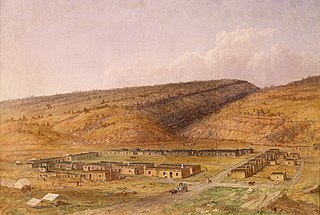
Fort Apache Historic Park is a tribal historic park of the White Mountain Apache, located at the former site of Fort Apache in the Fort Apache Indian Reservation. The park interprets the rich and troubled history of relations between the Apache and other Native American tribes at the fort, which was converted into a Bureau of Indian Affairs boarding school after its military use ended. The park, which covers 288 acres (117 ha) of the former fort and school, as well as a nearby military cemetery, form the National Historic Landmark Fort Apache and Theodore Roosevelt School historic district.
References
- ↑ Shaffer, Mark (1984-06-17). "Rural schools leaping at 4-day week". The Arizona Republic . Phoenix, Arizona. pp. B1, B10. - Clipping of first and of second page at Newspapers.com.
- ↑ "2020 CENSUS - SCHOOL DISTRICT REFERENCE MAP: Gila County, AZ" (PDF). U.S. Census Bureau . Retrieved 2022-01-30.