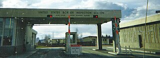
Alcan Border, also known as Port Alcan, is a census-designated place in the Southeast Fairbanks Census Area in the U.S. state of Alaska. Part of the Unorganized Borough, Alcan Border is the site of the Alcan - Beaver Creek Border Crossing, the main U.S. port of entry for persons arriving in Alaska by road. The population was 33 at the 2010 census, up from 21 in 2000.

Lutz is an unincorporated community in Hillsborough County and Pasco County, Florida, United States, 15 miles (24 km) north of Tampa. While there is a census-designated area of Lutz, the community itself extends beyond those boundaries into other census-designated areas.

Channelview is a census-designated place (CDP) in the U.S. state of Texas on the east side of Houston in Harris County. Its population was 45,688 at the 2020 U.S. census.

Sheldon is an unincorporated community and a census-designated place (CDP) in northeastern Harris County, Texas, United States, located completely inside the extraterritorial jurisdiction of the City of Houston. The Sheldon area is located along Beltway 8 and US Highway 90, approximately twelve miles (19 km) northeast of Downtown Houston.

Tornado, also called Upper Falls, is a census-designated place (CDP) in Kanawha County, West Virginia, United States.

Georgetown is an unincorporated community and census-designated place (CDP) in Bart Township, Lancaster County, Pennsylvania, United States. As of the 2010 census, the population was 1,022. Georgetown has a post office for P.O. boxes that is called Bart and has the ZIP code of 17503. Otherwise, the CDP is divided into three ZIP code areas for more distant communities.

Towner is a census-designated place (CDP) in and governed by Kiowa County, Colorado, United States. The population of the Towner CDP was 18 at the United States Census 2020. The Sheridan Lake post office serves Towner postal addresses. Towner's post office closed down in 1992.

Kingstowne is a census-designated place (CDP) in Fairfax County, Virginia, United States. It is a planned community amid the Washington, D.C. suburbs of Springfield, Alexandria, and Franconia, Virginia, and is centered on the intersection of South Van Dorn Street and Kingstowne Boulevard. The population as of the 2020 census was 16,825.

Nanafalia is an unincorporated community and census-designated place (CDP) in Marengo County, Alabama, United States. As of the 2020 census, its population was 75, down from 94 at the 2010 census. The community is located on a ridge above the Tombigbee River, and the name is derived from the Choctaw words for long hill. Nanafalia has a post office with a zip code of 36764.
Filer City is an unincorporated community and census-designated place in Filer Charter Township, Manistee County, Michigan, United States. Its population was 136 as of the 2020 census. The community is located on Manistee Lake just south of Manistee. Filer City has a post office with ZIP code 49634. The post office opened March 10, 1868, was discontinued on April 12, 1871, and reopened on July 13, 1883.

Stryker is an unincorporated community and census-designated place (CDP) in Lincoln County, Montana, United States. As of the 2010 census it had a population of 26. Stryker has the 59933 ZIP code.

Amherstdale is a census-designated place (CDP) in Logan County, West Virginia, United States, situated along Buffalo Creek. The CDP includes the unincorporated communities of Amherstdale, Becco, Fanco, and Braeholm. The CDP population was 350 as of the 2010 census.

Gila Crossing is a census-designated place (CDP) in Maricopa County, Arizona, United States, within the Gila River Indian Community south of Komatke. The population was 636 at the 2020 census.
Turner is an unincorporated village in Blaine County, Montana, United States. Turner is located on Montana State Highway 241, 41.5 miles (66.8 km) east-northeast of Chinook. It is 12 miles south of the Canadian border. Its population was 61 as of the 2010 census.

Hinsdale is an unincorporated community and census-designated place in Valley County, Montana, United States. The town's population was 217 and the community's population as a whole was 583 as of the 2010 census. The community is located on the Milk River and U.S. Route 2, with Montana Highway 537 headed north out of town and South Bench Road crossing the railroad tracks and running south of town. Hinsdale has a post office with ZIP code 59241.
McAllister is an unincorporated community and census-designated place in Madison County, Montana, United States. As of the 2020 census, it had a population of 278. McAllister is located on U.S. Route 287, 6 miles (10 km) north of Ennis. The community has a post office with ZIP code 59740.
Silver Star is an unincorporated community and census-designated place in Madison County, Montana, United States. As of the 2020 census, it had a population of 46. It is located on Montana Highway 41, 10 miles (16 km) north-northeast of Twin Bridges and 16 miles (26 km) southwest of Whitehall. The community has a post office with ZIP code 59751.
Mayking is an unincorporated community and census-designated place in Letcher County, Kentucky, United States. Its population was 475 as of the 2020 census. Mayking has a post office with ZIP code 41837, which opened on January 25, 1894. U.S. Route 119 passes through the community.
Linwood is a hamlet and census-designated place (CDP) in the town of York, Livingston County, New York, United States. Its population was 74 as of the 2010 census. Linwood had a post office until February 6, 1993; it still has its own ZIP code, 14486.
South Lima is a hamlet and census-designated place (CDP) in Livingston County, New York, United States. Its population was 240 as of the 2010 census. South Lima had a post office from January 10, 1854, until April 17, 2010; it still has its own ZIP code, 14558.


