Cassop is a village and former civil parish, now in the parish of Cassop-cum-Quarrington, in the County Durham district, in the ceremonial county of Durham, England. It has a population of about 500 and is located near the city of Durham. A former mining village, mining is no longer the main occupation of Cassop's inhabitants due to extensive mine closure over the last 30 years.
Kimblesworth is a village and former civil parish, now in the parish of Kimblesworth and Plawsworth, in the County Durham district, in the ceremonial county of Durham, England. It is situated between Durham and Chester-le-Street. The population Kimblesworth and Plawsworth at the 2011 Census was 1,614.

Plawsworth is a village and former civil parish, now in the parish of Kimblesworth and Plawsworth, in the County Durham district, in the ceremonial county of Durham, England. It is situated a short distance to the east of Sacriston, on the A167 between Durham and Chester-le-Street. In 1961 the parish had a population of 1570.

Cold Hesledon is a village and former civil parish, now in the parishes of Murton and Dalton-le-Dale, in the County Durham district, in the ceremonial county of Durham, England. It is situated a short distance to the east of Murton. In 1961 the parish had a population of 997.

Hett is a village and former civil parish, now in the parish of Croxdale and Hett, in the County Durham district, in the ceremonial county of Durham, England. It is situated a few miles south of Durham. Hett is largely surrounded by farmland. To the south, rape fields are predominant while at the northern end, cattle are grazed all year round. To the north-west of Hett lies Sunderland Bridge, a small hamlet with a population of under 50 people (2004). Hett contains a small pond, village hall and a football pitch. It is believed to derive its name from its topography - the village sits on a low rounded hill shaped like a hat.
Mainsforth is a small village and former civil parish, now in the parish of Bishop Middleham, in the County Durham district, in the ceremonial county of Durham, England. It is to the east of Ferryhill. The earliest settlement in Mainsforth may have been on Marble. It has been suggested, without great historical foundation, that this was a Danish settlement. In 1961 the parish had a population of 229.

Coundon is an old mining village and former civil parish in the County Durham district, in the ceremonial county of Durham, England. The Boldon Book mentions a mine in Coundon in the twelfth century. In 2001 it had a population of 2611. In 2011 the ward had a population of 7139.

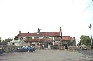
Cowpen Bewley is a village and former civil parish, now in the parish of Billingham, in the Stockton-on-Tees district, in the ceremonial county of Durham, England. In 1931 the parish had a population of 706.

Newfield is a village and former civil parish in the County Durham district, in the ceremonial county of Durham, England. It is situated to the south of Willington, near Bishop Auckland. In the 2001 census Newfield had a population of 368.

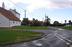
Embleton is a hamlet and former civil parish, now in the parish of Sedgefield, in the County Durham district, in the ceremonial county of Durham, in England, as well as the site of a medieval village and manor. It is situated 3 miles (5 km) east of Sedgefield and 4 miles (6 km) west of Hartlepool. In 1961 the parish had a population of 80. The township was historically named "Elmdene", supposedly derived from the site's proximity to a woodland of elm trees which, at an earlier time, flourished in the bordering dene. A single farmstead now occupies the site which lies adjacent to the ruins of a small church dedicated to the Virgin Mary.
Anick is a village and former civil parish, now in the parish of Sandhoe, in Northumberland, England, situated to the north of Hexham. In 1881 the parish had a population of 153.

Cherrington is a village and former civil parish, now in the parish of Tibberton and Cherrington, in the Telford and Wrekin district, in the ceremonial county of Shropshire, England. It was recorded as a manor in Domesday, when it was held by Gerard de Tournai, and was stated to have been held by a man named Uliet in the time of Edward the Confessor, although it was recorded as "waste", in an uncultivated state, by the time Gerard took possession of it. In 1961 the parish had a population of 122.

Stillington is a village and former civil parish, now in the parish of Stillington and Whitton, in the Stockton-on-Tees district, in the ceremonial county of Durham, England, northwest of Stockton-on-Tees.

Offerton is a hamlet and former civil parish, now in the unparished area of Houghton le Spring, in the Sunderland district, in the county of Tyne and Wear, England. Situated about 4 miles west-southwest of Sunderland city centre. In 1961 the parish had a population of 133.
Newton on the Moor is a village and former civil parish in Northumberland, England. It is located 5 miles (8 km) south of Alnwick, on the old route of the A1 road although the village has now been bypassed just to the east. The village is now in the civil parish of Newton on the Moor and Swarland, which also includes the village of Swarland, south-west of Newton on the Moor. The population of Newton on the Moor and Swarland parish in 2001 was 822, increasing to 905 at the 2011 Census. The village is a conservation area.
Sutton is a small village and former civil parish, now in the parish of Norton, in the City of Doncaster in South Yorkshire, England. It lies at approximately 53° 36' 20" North, 1° 10' West, at an elevation of around 26 feet above sea level, west of Askern and south of Campsall. In 1931 the civil parish had a population of 156.

Bilsborrow is a village and former civil parish, now in the parish of Myerscough and Bilsborrow, in the Wyre district, in the county of Lancashire, England. The village population at the 2011 census was 632. It is on the A6 road and the Lancaster Canal. It is approximately 1 mile (2 km) east of Myerscough.

Pipehill is a hamlet and former civil parish, now in the parish of Hammerwich, in the Lichfield district, in the county of Staffordshire, England. It is located between Wall and Hammerwich. In 1891 the parish had a population of 139.

Sunderland Bridge is a village and former civil parish, now in the parish of Croxdale and Hett, in the County Durham district, in the ceremonial county of Durham, England. It is about 3 miles (4.8 km) south of Durham city. In 1961 the parish had a population of 907.