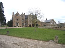
North Petherton is a small town and civil parish in Somerset, England, situated on the edge of the eastern foothills of the Quantocks, and close to the edge of the Somerset Levels. The town has a population of 6,730. The parish includes Hamp, Melcombe, Shearston, Woolmersdon and Huntworth.

Ashill is a small village and civil parish in Somerset, England, situated 7 miles (11.3 km) south of Taunton, and three miles north-west of Ilminster in the South Somerset district. The parish includes the hamlet of Windmill Hill and has a population of 529.
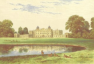
Badminton House is a large country house and Grade I Listed Building in Badminton, Gloucestershire, England, and has been the principal seat of the Dukes of Beaufort since the late 17th century, when the family moved from Raglan Castle, which had been ruined in the English Civil War. The house gives its name to the sport of badminton. The gardens and park surrounding the house are Grade I on the Register of Historic Parks and Gardens.

Dowlish Wake is a small village and civil parish in Somerset, England, 2 miles (3 km) south of Ilminster and 5 miles (8 km) northeast of Chard in the South Somerset district. With a population of 277, it has several thatched houses and a pub called The New Inn. Its post office closed in 1991.

Stoke St Gregory is a village and civil parish in Somerset, England, about 7 miles (11 km) east of Taunton in the Somerset West and Taunton district. The village is on a low ridge of land between the River Tone to the north and West Sedgemoor to the south. The 2011 Census recorded the parish's population as 942.

Chaffcombe is a village and civil parish in Somerset, England, situated 2 miles (3.2 km) north east of Chard in the South Somerset district. The village has a population of 229.

Cricket St Thomas is a parish in Somerset, England, situated in a valley between Chard and Crewkerne within the South Somerset administrative district. The A30 road passes nearby. The parish has a population of 50. It is noted for the historic manor house known as Cricket House, and its estate in recent times formerly home to a wildlife park.

Lytes Cary is a manor house with associated chapel and gardens near Charlton Mackrell and Somerton in Somerset, England. The property, owned by the National Trust, has parts dating to the 14th century, with other sections dating to the 15th, 16th, 18th, and 20th centuries. "Yet all parts blend to perfection with one another and with the gentle sunny landscape that surrounds them," comments Nikolaus Pevsner. The House is listed as Grade I by English Heritage.

Stoke sub Hamdon Priory is a complex of buildings and ruins which initially formed a 14th-century college for the chantry chapel of St Nicholas, and later was the site of a farm in Stoke-sub-Hamdon, Somerset, England. The only building remaining from the college is a great hall and attached dwelling, dating from the late 15th century. The hall is designated by English Heritage as a Grade I listed building, while the outbuildings and gateway are Grade II listed. The whole site has been scheduled as an ancient monument. A number of the farm buildings are in poor condition, and have been added to the Heritage at Risk Register.

South Petherton is a village and civil parish in the South Somerset district of Somerset, England, located 5 miles (8 km) east of Ilminster and 5 miles (8 km) north of Crewkerne. The parish had a population of 3,367 in 2011 and includes the smaller village of Over Stratton and the hamlets of Compton Durville, Drayton, Wigborough and Yeabridge. The River Parrett forms the eastern boundary of the parish. The village is approximately 2 miles (3 km) from East Lambrook, Martock and Lopen.
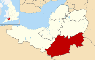
South Somerset is a local government district in the English county of Somerset. The South Somerset district occupies an area of 370 square miles (958 km2), stretching from its borders with Devon and Dorset to the edge of the Somerset Levels. The district has a population of about 158,000, and has Yeovil as its administrative centre.

Gothelney Hall, also known as Gothelney Manor Farmhouse, located in the parish of Spaxton, Somerset, England was built in the 15th century and has been designated as a Grade I listed building.

Burton Pynsent House is a historic country-house in the parish of Curry Rivel, Somerset, England. It is a Grade II* listed building. The house was built in stages between 1565 and 1765, when it was bequeathed to William Pitt, 1st Earl of Chatham by Sir William Pynsent, 2nd Baronet, who did not want the house to go to Lord North. Pitt had an additional wing built to a design by Lancelot Brown, and the subsequent owner demolished everything but this wing in 1805.

Fairfield House is a historic house in Stogursey, Somerset, England. A house existed on the site from the 12th century and it has been owned by the same family since that time. The current building is largely 16th-century, but has undergone various remodellings since then. It is designated as a Grade II* listed building.

West Somerset is a local government district in the county of Somerset which is in South West England. In the United Kingdom, the term listed building refers to a building or other structure officially designated as being of special architectural, historical or cultural significance; Grade II* structures are those considered to be "particularly significant buildings of more than local interest". Listing was begun by a provision in the Town and Country Planning Act 1947. Once listed, severe restrictions are imposed on the modifications allowed to a building's structure or its fittings. In England, the authority for listing under the Planning Act 1990 rests with Historic England, a non-departmental public body sponsored by the Department for Digital, Culture, Media and Sport; local authorities have a responsibility to regulate and enforce the planning regulations.
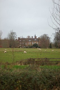
Maunsel House in the English county of Somerset was built in the late 14th or early 15th century. The house stands south of the hamlet of North Newton, in the parish of North Petherton. It is the family seat of the Slade baronets and is a Grade II* listed building.

Over Stratton is a small village in the district of South Somerset, Somerset, England. It is part of the parish of South Petherton along with the nearby hamlets of Lower Stratton, Wigborough, Yeabridge and Watergore. As of census day 2011, the population was 317.

Gournay Court in the parish of West Harptree, Somerset, England, is a country house built circa 1600. The house, along with the manor of West Harptree, was owned by the Duchy of Cornwall. During World War I, it became a hospital. In 1928, it was bought by Sir Edward Geoffrey Hippisley-Cox. It is now the residence of the local Member of Parliament (MP) Jacob Rees-Mogg and his family.

West Bower Manor in Durleigh within the English county of Somerset was largely built in the 15th century. It is a Grade II* listed building.
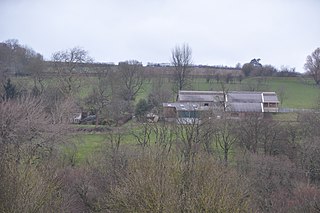
Hill Farm in Stawley, Somerset, England was built in the late 16th century. It is a Grade II* listed building.
