Wigtown County Buildings

Last updated

Wigtown County Buildings
Wigtown Town Hall - geograph.org.uk - 1232692.jpg
Wigtown County Buildings
LocationThe Square, Wigtown
Coordinates 54°52′07″N4°26′29″W / 54.8685°N 4.4413°W / 54.8685; -4.4413 Coordinates: 54°52′07″N4°26′29″W / 54.8685°N 4.4413°W / 54.8685; -4.4413
Built1863
Architect Thomas Brown II
Architectural style(s) Gothic Revival style
Listed Building – Category B
Official nameWigtown Town Hall (former Wigtown Sheriff Court) including railings, The Square, Wigtown
Designated20 July 1972
Reference no.LB42439
Dumfries and Galloway UK location map.svg
Red pog.svg
Shown in Dumfries and Galloway

Wigtown County Buildings, also known as Wigtown County Buildings and Town Hall, [1] [2] is a municipal building in The Square, Wigtown, Scotland. The structure was only briefly the headquarters of Wigtownshire County Council and primarily served as the meeting place and town hall for Wigtown Burgh Council. It is a Category B listed building. [3]

Contents

History

The first municipal building in Wigtown was a tolbooth which was completed in the 16th century. [4] Two covenanters, Margaret Maclauchlan and Margaret Wilson, were held in a cell in the tolbooth before being executed by Scottish Episcopalians in 1685 by tying them to stakes on the town's mudflats and allowing them to drown with the rising tide: they are remembered as the Wigtown Martyrs. [5] The tolbooth was replaced by a new town hall which was completed in 1756. [6]

In the early 1860s, burgh officials decided to demolish the 18th century town hall and to erect a structure more in keeping with the importance of Wigtown as the administrative centre of the county of Wigtownshire. [7] The new building was designed by Thomas Brown II in the Gothic Revival style, built in red sandstone and was completed in 1863. [8] The design involved a symmetrical main frontage with eight bays facing onto The Square; the central section of two bays featured a doorway with a stone surround and the burgh coat of arms in the tympanum. [3] The doorway was flanked by buttresses supporting a balcony with heraldic lions at the corners. [3] The other bays on the ground floor and the bays on the first floor were fenestrated with gothic windows. [3] On the north elevation of the building, there was a three-stage projecting tower with louvres and a clock in the third stage and a pyramid-style roof above. [3] A coat of arms, which had been recovered from the 18th century town hall was installed above the door on the northern elevation. [3] Internally, the principal room was the courtroom on the first floor. [3] There was also a cell with a barrel-vaulted ceiling, which had formed part of the 18th century town hall, in the part of the building behind the tower. [3]

Following the implementation of the Local Government (Scotland) Act 1889, which established a uniform system of county councils in Scotland, the new Wigtownshire County Council was initially based in the building, although by the 1920s, the county council had moved to the new County Offices in Sun Street, Stranraer. [9] The building continued to serve as the headquarters of Wigtown Burgh Council for much of the 20th century but ceased to be the local seat of government after the enlarged Wigtown District Council was formed at the Council Offices in Sun Street in Stranraer in 1975. [10] [11] However, the building served instead as the meeting place for the local community council. [12]

With financial support from the Heritage Lottery Fund, a programme of refurbishment works was carried out and completed in 2003. [13] The works built on an initiative started in 1999 to make Wigtown the "national book town" for Scotland and involved the creation of a library named after the local author, John McNeillie, and the creation of a small local history museum: items put on display in the museum included a set of early 18th century imperial measures, typically held by local authorities to ensure tradesmen comply with the Weights and Measures Act 1824. [7]

In September 2018, a memorial stone was laid outside the town hall to commemorate the life of Sergeant Louis McGuffie who had been posthumously awarded the Victoria Cross for his actions at the Fifth Battle of Ypres during the First World War. [14]

See also

Related Research Articles

Dumfries and Galloway Council area of Scotland

Dumfries and Galloway is one of 32 unitary council areas of Scotland and is located in the western Southern Uplands. It comprises the historic counties of Dumfriesshire, Kirkcudbrightshire, and Wigtownshire, the latter two of which are collectively known as Galloway. The administrative centre and largest settlement is the town of Dumfries. The second largest town is Stranraer, 75 miles to the west on the Irish Sea coast.

Wigtown Human settlement in Scotland

Wigtown is a town and former royal burgh in Wigtownshire, of which it is the county town, within the Dumfries and Galloway region in Scotland. It lies east of Stranraer and south of Newton Stewart. It is known as "Scotland's National Book Town" with a high concentration of second-hand book shops and an annual book festival.

Stranraer Town and sea port in Scotland

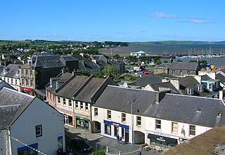
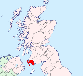
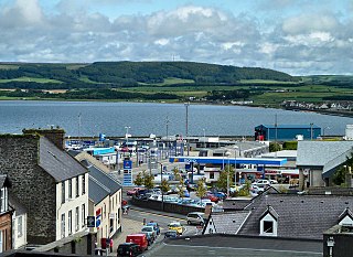
Stranraer, also known as The Toon, is a town in Dumfries and Galloway, Scotland. It is located in the historical parish of Inch in the historic county of Wigtownshire. It lies on the shores of Loch Ryan, on the northern side of the isthmus joining the Rhins of Galloway to the mainland. Stranraer is Dumfries and Galloway's second-largest town, with a population including the immediate surrounding area of nearly 13,000 inhabitants.

Kirkcudbrightshire Historic county in Scotland

Kirkcudbrightshire, or the County of Kirkcudbright or the Stewartry of Kirkcudbright, is a historic county, registration county and lieutenancy area in the informal Galloway area of south-western Scotland. For local government purposes, it forms part of the wider Dumfries and Galloway council area of which it forms a committee area under the name of the Stewartry.

Newton Stewart Human settlement in Scotland

Newton Stewart is a former burgh town in the historical county of Wigtownshire in Dumfries and Galloway, southwest Scotland. The town is on the River Cree with most of the town to the west of the river, and is sometimes referred to as the "Gateway to the Galloway Hills".

Wigtownshire Historic county in Scotland

Wigtownshire or the County of Wigtown is a historic county, registration county and lieutenancy area in south-west Scotland. It is popularly known as and referred to as The Shire. Until 1975, Wigtownshire was one of the administrative counties used for local government purposes, and is now administered as part of the council area of Dumfries and Galloway. As a lieutenancy area, Wigtownshire has its own Lord Lieutenant, currently John Alexander Ross. In the 19th century, it was also called West Galloway. The county town was historically Wigtown, with the administrative centre moving to Stranraer, the largest town, on the creation of a county council in 1890.

Wigtown Burghs, also known as Wigton Burghs,. was a constituency of the House of Commons of the Parliament of Great Britain from 1708 to 1800 and of the House of Commons of the Parliament of the United Kingdom from 1801 to 1885. It was represented by one Member of Parliament (MP).

Galloway and West Dumfries (Scottish Parliament constituency) Region or constituency of the Scottish Parliament

Galloway and West Dumfries is a constituency of the Scottish Parliament (Holyrood) covering part of the council area of Dumfries and Galloway. It elects one Member of the Scottish Parliament (MSP) by the plurality method of election. It is also one of nine constituencies in the South Scotland electoral region, which elects seven additional members, in addition to the nine constituency MSPs, to produce a form of proportional representation for the region as a whole.

Inch, Dumfries and Galloway Human settlement in Scotland

Inch is a civil parish in Dumfries and Galloway, southwest Scotland. It lies on the shore of Loch Ryan, in the traditional county of Wigtownshire.

Wigtown Harbour

Wigtown Harbour or Wigtown Quay was relocated in 1818 to serve the town of Wigtown and its hinterland in Wigtownshire, Dumfries and Galloway, following the silting up of the original natural harbour that was originally located near to St Machute's church. This relocation occurred following centuries of silting and then the alteration of the course of the River Bladnoch that runs into Wigtown Bay where it joins the River Cree.

Municipal Buildings, Dumfries Municipal Building in Dumfries, Scotland

The Municipal Buildings are based on the north side of Buccleuch Street, Dumfries, Dumfries and Galloway, Scotland. The structure, which was the headquarters of Dumfries Burgh Council, is a Category C listed building.

Musselburgh Tolbooth Municipal building in Musselburgh, Scotland

Musselburgh Tolbooth is a municipal building in the High Street in Musselburgh, East Lothian, Scotland. The tolbooth, which was the headquarters of Musselburgh Burgh Council, is a Category A listed building. At right angles and attached to it is the Musselburgh Town House.

Prestwick Burgh Hall Municipal building in Prestwick, Scotland

Prestwick Burgh Hall, also known as Prestwick Freeman's Hall and Prestwick Freemen's Hall, is a municipal building in Kirk Street, Prestwick, Scotland. The structure, which served as the meeting place of Prestwick Burgh Council, is a Category B listed building.

Forfar Town and County Hall Municipal building in Forfar, Scotland

Forfar Town and County Hall is a municipal building in The Cross, Forfar, Scotland. The structure, which serves as the meeting place of Angus Council, is a Category B listed building.

Kirkcudbright Town Hall Municipal building in Kirkcudbright, Scotland

Kirkcudbright Town Hall is a municipal building in St Mary's Street, Kirkcudbright, Scotland. The building, which was the headquarters of Kirkcudbright Burgh Council, is a Category B listed building.

Kelso Town Hall Municipal building in Kelso, Scotland

Kelso Town Hall is a municipal building in The Square, Kelso, Scotland. The building, which was the headquarters of Kelso Burgh Council, is a Category B listed building.

Old Town Hall, Stranraer Municipal building in Stranraer, Scotland

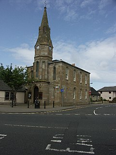
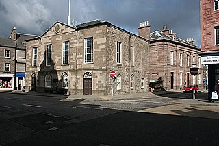
The Old Town Hall is a municipal structure in George Street, Stranraer, Dumfries and Galloway, Scotland. The structure, which is used as a local history museum, is a Category A listed building.

Cupar Burgh Chambers Municipal Building in Cupar, Scotland

Cupar Burgh Chambers is a municipal structure in St Catherine Street in Cupar, Fife, Scotland. The building, which was the meeting place of Cupar Burgh Council, is a Category B listed building.

Crail Tolbooth and Town Hall Municipal Building in Crail, Scotland

Crail Tolbooth and Town Hall is a municipal structure in Crail, Fife, Scotland. The building, which stands in Marketgate, at its junction with Tolbooth Wynd, is Category A listed.

References

  1. Curl, James Stevens; Wilson, Susan (2015). Oxford Dictionary of Architecture. Oxford University Press. p. 823. ISBN   978-0199674985.
  2. Jaques, Richard (2000). "Falkirk and District: An illustrated Architectural Guide". Rutland Press. p. 33. ISBN   978-1873190081.
  3. 1 2 3 4 5 6 7 8 Historic Environment Scotland. "Wigtown Town Hall (former Wigtown Sheriff Court) including railings, The Square, Wigtown (LB42439)" . Retrieved 3 August 2021.
  4. Historic Environment Scotland. "Wigtown, The Square, County Buildings (215461)". Canmore . Retrieved 3 August 2021.
  5. "Scotland's drowned martyrs, Wigtown, Dumfries and Galloway". The Guardian. 8 June 2009. Retrieved 3 August 2021.
  6. Groome, F. H. (1884). "Wigtown". Ordnance Gazetteer of Scotland. Retrieved 3 August 2021.
  7. 1 2 "Wigtown County Buildings". Future Museum. Retrieved 2 August 2021.
  8. "Wigtown County Buildings". Dictionary of Scottish Architects. Retrieved 3 August 2021.
  9. "No. 14265". The Edinburgh Gazette . 7 September 1926. p. 1006.
  10. "Local Government (Scotland) Act 1973". Legislation.gov.uk. Retrieved 16 April 2020.
  11. "No. 19991". The Edinburgh Gazette . 3 December 1976. p. 1622.
  12. "Council Meeting Agenda". Royal Burgh of Wigtown and District Community Council. 9 September 2019. Retrieved 3 August 2021.
  13. "Townscape Heritage Initiative Schemes Evaluation: 10 Year Review Report" (PDF). Oxford Brookes University. 2013. p. 198. Retrieved 3 August 2021.
  14. "Wigtown soldier honoured for bravery 100 years on". BBC. 28 September 2018. Retrieved 3 August 2021.