Wildlife of Egypt

Last updated

Vegetation beside the Nile near Aswan Aswan Nile R09.jpg
Vegetation beside the Nile near Aswan

The wildlife of Egypt is composed of the flora and fauna of this country in northeastern Africa and southwestern Asia, and is substantial and varied. Apart from the fertile Nile Valley, which bisects the country from south to north, the majority of Egypt's landscape is desert, with a few scattered oases. It has long coastlines on the Mediterranean Sea, the Gulf of Suez, the Gulf of Aqaba and the Red Sea. Each geographic region has a diversity of plants and animals each adapted to its own particular habitat.

Contents

Geography

Topographical map of Egypt Egypt Topography.png
Topographical map of Egypt

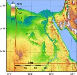
Egypt is bordered by the Mediterranean Sea to the north, Libya to the west and Sudan to the south. To the east lies the Red Sea, and the Sinai Peninsula, the Asian part of the country, which is bordered by the Gaza Strip and Palestine. Egypt is a transcontinental nation, providing a land bridge between Africa and Asia. This is traversed by the Suez Canal which connects the Mediterranean Sea with the Indian Ocean by way of the Red Sea. [1] This results in the flora and fauna having influences from both Africa and Asia, and the marine life from both the Atlantic / Mediterranean Sea and the Red Sea / Indian Ocean.

The River Nile enters Egypt as it flows through Lake Nasser, formed by the building of the Aswan Dam. In its lower reaches, the river is about 0.75 km (0.5 mi) wide and the alluvial plain about 10 km (6 mi) wide. [2] The annual flooding of the Nile no longer occurs and the fertility of the Nile Valley is now maintained by irrigation rather than the deposition of silt. Much of the Nile is bordered by flat land but in some places there are low cliffs. Where the river flows into the Mediterranean, there is an extensive fan-shaped delta area with channels, lakes and salt marshes. [1]

Desert in Sinai Sinai R01.jpg
Desert in Sinai

To the west of the Nile lies the Western Desert, occupying about two-thirds of the area of the country. It consists largely of high stony and sandy plains with rocky plateaux in places. In the extreme southwest of the country on the border with Libya and Sudan, is Jebel Uweinat, a mountainous region and in the northwest lies the Qattara Depression, a large area of land some 133 m (436 ft) below sea level. Another depression, the Faiyum Oasis lies south west of Cairo and is connected to the Nile by a channel. To the east of the Nile lies the much smaller Eastern Desert, a high mountain ridge running parallel with the Red Sea, seamed with wadis on either flank. At the border with Sudan this rises to the rocky massif of Gebel Elba. The Sinai Peninsula is a mountainous area, deeply cleft by canyon-like wadis that flow towards the Gulf of Aqaba, the Gulf of Suez and the Mediterranean Sea. [2]

In general, Egypt is a very dry country. The Western Desert receives only occasional rainfall, the winters being mild and the summers very hot. The Eastern Desert receives some precipitation in the south in the form of orographic rainfall from winds that have crossed the Red Sea; this may cause torrential flows in the wadis. The winters here are mild and the summers hot, and Gebel Elba is cooler and wetter than other parts. The northern areas of the country, particularly close to the coast, receive some precipitation from Mediterranean weather systems. [2]

Flora

Zygophyllum album, a desert plant Zygophyllum album Metlaoui Tunisia.JPG
Zygophyllum album , a desert plant
Date palm Phoenix dactylifera1.jpg
Date palm

The Nile is the lifeline of Egypt, the land bordering the river being rendered fertile by the irrigation it receives. Crops grown in the Nile Valley include cotton, cereals, sugarcane, beans, oil seed crops and peanuts. [3] Date palms grow here as well as sycamore, carob and Acacia . Fruit trees are planted here and eucalyptus has been introduced. The rich delta soil is used for the cultivation of grapes, vegetables and flowers. The papyrus reeds that used to line the river are now restricted to the far south of the country, as are the crocodiles and hippopotamuses that also used to be plentiful. [4]

Large parts of the Western Desert are completely devoid of vegetation. The plants that do grow are adapted to the arid conditions and tend to be small and wiry, have small, leathery leaves, long shallow roots to exploit any available water, prickles or thorns to deter herbivores, and sometimes thick stems or leaves to store water. They include acacia trees, palms, succulents, spiny shrubs, and grasses. Some plants adopt an ephemeral life style, sprouting or springing into life when rain falls, rapidly reaching the flowering stage and producing long-lived durable seed. [5] In depressions in the Western Desert, some plant communities are dominated by Zygophyllum album , Nitraria retusa and Tamarix nilotica . In the Siwa Oasis there are small lakes, reedbeds dominated by Phragmites australis and Typha domingensis , and saltmarshes with Arthrocnemum macrostachyum , Juncus rigidus , Alhagi maurorum , Cladium mariscus and Cressa cretica . [6]

In the mountains of the Eastern Desert grows the tree Balanites aegyptiaca , the open patchy woodland being remnants of forests that used to cover this region. In the Gulf of Suez coastal area the rainfall is supplemented by condensation from clouds. Water may ooze from cracks, flow down runnels and collect in potholes. Here mosses, ferns and various vascular plants grow, and Ficus pseudosycamorus and stunted date palms grow from cracks. [7]

The flora of the Sinai Peninsula mountains is very varied and is largely of Irano-Turanian origin. Here soil and plant litter accumulates in crevices and depressions in the rock and provides anchorage for roots. The commonest plant is Artemisia inculta , and rocky slopes support shrubs, semi-shrubs and trees. [8]

Fauna

The endemic pallid gerbil Perpallidus.jpg
The endemic pallid gerbil
Dorcas gazelle The book of antelopes (1894) Gazella dorcas.png
Dorcas gazelle
The endangered Egyptian vulture Egyptian vulture.jpg
The endangered Egyptian vulture

At one time Egypt had a cooler, wetter climate than it has today; ancient tomb paintings show giraffes, hippopotamuses, crocodiles and ostriches, [9] and the petroglyphs at Silwa Bahari on the upper Nile, between Luxor and Aswan, show African bush elephants, white rhinoceroses, gerenuk and more ostriches, a fauna akin to that of present-day East Africa. [10] Nor does the country have many endemic species, these being limited to the Egyptian weasel, pallid gerbil, Mackilligin's gerbil (this may possibly extend into the Sudan), Flower's shrew, Nile Delta toad, and two butterflies, the Sinai baton blue and Satyrium jebelia . [10]

Mammals of the Western Desert have been depleted over the years and the addax and scimitar oryx are no longer found there, and the Atlas lion has probably gone as well. The remaining mammals include the rhim gazelle, dorcas gazelle, Barbary sheep, Rüppell's fox, lesser Egyptian jerboa and Giza gerbil. Notable birds from this desert include the spotted sandgrouse, greater hoopoe-lark and white-crowned wheatear. [10]

The Eastern Desert has a quite different range of fauna and has much in common with the Sinai Peninsula, showing the importance of the broad Nile in separating the two desert regions. Here are found the striped hyena, Nubian ibex, bushy-tailed jird, golden spiny mouse, Blanford's fox and Rüppell's fox. The sand partridge, streaked scrub warbler, mourning wheatear and white-crowned wheatear are typical of this region. The high rocky mountains of Gebel Elba in the south have a distinctive range of animals including the aardwolf, striped polecat, and common genet, and there may still be African wild ass in this area. [10]

Birds are abundant in Egypt, especially in the Nile Valley and the Delta region. Birds of prey include vultures, eagles, hawks, falcons and owls. Other large birds include storks, flamingoes, herons, egrets, pelicans, quail, sunbirds and golden orioles. [4] About four hundred and eighty species of bird have been recorded, the globally endangered ones being the red-breasted goose, white-headed duck, Balearic shearwater, Egyptian vulture, Rüppell's vulture, sociable lapwing, slender-billed curlew, saker falcon and yellow-breasted bunting. [11] Egypt is on a major bird migratory route between Eurasia and East Africa and around two hundred species of migrants pass through twice a year. [9]

About thirty species of snake occur in Egypt, about half of them venomous. These include the Egyptian cobra, false smooth snake and horned viper. There are also numerous species of lizards. [9] Above the Aswan Dam, the shores of Lake Nasser are largely barren, but the lake does support the last remaining Nile crocodiles and African softshell turtle in Egypt. [10]

Over one hundred species of fish live in the Nile and the Delta region. [4] Egypt also has a large aquaculture industry producing tilapia in semi-intensive pond systems. [12]

Related Research Articles

<span class="mw-page-title-main">Geography of Egypt</span> Geographical features of Egypt

The geography of Egypt relates to two regions: North Africa and Southwest Asia.

<span class="mw-page-title-main">Transport in Egypt</span>

Transport in Egypt is centered in Cairo and largely follows the pattern of settlement along the Nile. The Ministry of Transportation and other government bodies are responsible for transportation in Egypt, whether by sea, river, land or air.

<span class="mw-page-title-main">Nile</span> Major river in northeastern Africa

The Nile is a major north-flowing river in northeastern Africa. It flows into the Mediterranean Sea. The Nile is the longest river in Africa and has historically been considered the longest river in the world, though this has been contested by research suggesting that the Amazon River is slightly longer. Of the world's major rivers, the Nile is one of the smallest, as measured by annual flow in cubic metres of water. About 6,650 km (4,130 mi) long, its drainage basin covers eleven countries: the Democratic Republic of the Congo, Tanzania, Burundi, Rwanda, Uganda, Kenya, Ethiopia, Eritrea, South Sudan, Republic of the Sudan, and Egypt. In particular, the Nile is the primary water source of Egypt, Sudan and South Sudan. Additionally, the Nile is an important economic river, supporting agriculture and fishing.

<span class="mw-page-title-main">Geography of Sudan</span> Geographical features of Sudan

Sudan is located in Northeast Africa. It is bordered by Egypt to the north, the Red Sea to the northeast, Eritrea and Ethiopia to the east, South Sudan to the south, the Central African Republic to the southwest, Chad to the west and Libya to the northwest. Sudan is the third largest country in Africa, after Algeria and the Democratic Republic of the Congo. It had been the largest country on the continent until the 2011 independence of South Sudan.

<span class="mw-page-title-main">Eduard Rüppell</span> German naturalist and explorer (1794–1884)

Wilhelm Peter Eduard Simon Rüppell, also spelled Rueppell was a German naturalist and explorer, best known for his collections and descriptions of plants and animals from Africa and Arabia.

<span class="mw-page-title-main">Red Sea Governorate</span> Governorate of Egypt

Red Sea Governorate is one of the 27 governorates (States) of Egypt. Located between the Nile and the Red Sea in the southeast of the country, its southern border forms part of Egypt's border with Sudan. Its capital and largest city is Hurghada.

<span class="mw-page-title-main">Nile Delta</span> Delta produced by the Nile River at its mouth in the Mediterranean Sea

The Nile Delta is the delta formed in Lower Egypt where the Nile River spreads out and drains into the Mediterranean Sea. It is one of the world's largest river deltas—from Alexandria in the west to Port Said in the east, it covers 240 km (150 mi) of Mediterranean coastline and is a rich agricultural region. From north to south the delta is approximately 160 km (100 mi) in length. The Delta begins slightly down-river from Cairo.

<span class="mw-page-title-main">Halaib Triangle</span> Disputed territory between Egypt and Sudan

The Halaib Triangle is an area of land measuring 20,580 square kilometres (7,950 sq mi) located on the Northeast African coast of the Red Sea. The area, which takes its name from the town of Halaib, is created by the difference in the Egypt–Sudan border between the "political boundary" set in 1899 by the Anglo-Egyptian Condominium, which runs along the 22nd parallel north, and the "administrative boundary" set by the British in 1902, which gave administrative responsibility for an area of land north of the line to Sudan, which was an Anglo-Egyptian client at the time. With the independence of Sudan in 1956, both Egypt and the Sudan claimed sovereignty over the area. The area has been considered to be a part of the Sudan's Red Sea State, and was included in local elections until the late 1980s. In 1994 the Egyptian military moved to take control of the area as a part of Red Sea Governorate, and Egypt has been actively investing in it since then. Egypt has been recently categorical in rejecting international arbitration or even political negotiations regarding the area.

<span class="mw-page-title-main">Eastern Desert</span> Sahara desert east of the Nile river

The Eastern Desert is the part of the Sahara desert that is located east of the Nile river. It spans 223,000 square kilometres (86,000 sq mi) of North-Eastern Africa and is bordered by the Nile river to the west and the Red Sea and Gulf of Suez to the east. It extends through Egypt, Eritrea, Sudan and Ethiopia. The Eastern Desert is also known as the Red Sea Hills. The Desert consists of a mountain range which runs parallel to the coast, wide sedimentary plateaus extending from either side of the mountains and the Red Sea coast. The rainfall, climate, vegetation and animal life sustained in the desert varies between these different regions.The Desert has been a mining site for building materials, and precious and semi-precious metals throughout history. It has historically contained many trade routes leading to and from the Red Sea, including the Suez Canal.

<span class="mw-page-title-main">Red Sea Riviera</span> Egypts eastern coastline along the Red Sea

The Red Sea Riviera, Egypt's eastern coastline along the Red Sea, consists of resort cities on the western shore of the Gulf of Aqaba and along the eastern coast of mainland Egypt, south of the Gulf of Suez. The combination of a favorable climate, warm sea, thousands of kilometers of shoreline, and abundant natural and archaeological points of interest makes this stretch of Egypt's coastline a popular national and international tourist destination. There are numerous National Parks along the Red Sea Riviera, both underwater and on land. Desert and marine life are protected by several laws, and visitors may be subject to heavy fines for not abiding.

<i>Nitraria retusa</i> Species of plant in the family Nitrariaceae

Nitraria retusa, commonly known as Nitre bush, is a salt-tolerant and drought-resistant shrub in the family Nitrariaceae. It can grow to heights of 2.5 metres, although it seldom exceeds more than 1 m in height. It produces small white/green coloured flowers and small edible red fruit. The plant is native to desert areas of northern Africa, where it grows in primary succession on barren sand dunes, and in areas with high salinities such as salt marshes.

<span class="mw-page-title-main">Lake Bardawil</span> Lagoon on the north coast of the Sinai Peninsula in Egypt

Lake Bardawil, is a large, very saline lagoon nearby the protected area of Zaranik in Egypt on the north coast of the Sinai Peninsula. Lake Bardawil is about 30 kilometers (19 mi) long, and 14 kilometers (8.7 mi) wide. It is considered to be one of the three major lakes of the Sinai Peninsula, along with the Great Bitter Lake and the Little Bitter Lake. It continues to decrease in size as sands move and is becoming more of a Playa or Sabkha than a lake. Between Port Said and Rafah are three main sabkha which extend from west to east: Sabkhat El Malaha, Sabkhat Bardawil and Sabkhat El Sheikh Zawayed.

Water resources management in modern Egypt, is a complex process that involves multiple stakeholders who use water for irrigation, municipal and industrial water supply, hydropower generation and navigation. In addition, the waters of the Nile support aquatic ecosystems that are threatened by abstraction and pollution. Egypt also has substantial fossil groundwater resources in the Western Desert.

<span class="mw-page-title-main">Environmental issues in Egypt</span>

Egypt's environmental problems include, but are not limited to, water scarcity, air pollution, damage to historic monuments, animal welfare issues and deficiencies in its waste management system.

<span class="mw-page-title-main">Nile Basin</span> Part of Africa drained by the Nile River and its tributaries

The Nile Basin is the part of Africa drained by the Nile River and its tributaries.

The wildlife of Yemen is substantial and varied. Yemen is a large country in the southern half of the Arabian Peninsula with several geographic regions, each with a diversity of plants and animals adapted to their own particular habitats. As well as high mountains and deserts, there is a coastal plain and long coastline. The country has links with Europe and Asia, and the continent of Africa is close at hand. The flora and fauna have influences from all these regions and the country also serves as a staging post for migratory birds.

<i>Tamarix nilotica</i> Species of plant

Tamarix nilotica, the Nile tamarisk is a species of shrub or small tree in the tamarisk family. It is found in arid parts of North Africa and the Middle East, particularly areas with high salinity. It forms part of the dune stabilisation process.

The Moghra Oasis is an uninhabited oasis in the northeastern part of the Qattara Depression in the Western Desert of Egypt. It has a 4 km2 (1.5 sq mi) lake containing brackish water, salt marshes and a swamp with reeds.

<span class="mw-page-title-main">Red Sea coastal desert</span>

The Red Sea coastal desert is deserts and xeric shrublands ecoregion of Egypt and Sudan.

References

  1. 1 2 Philip's (1994). Atlas of the World. Reed International. pp. 86–87. ISBN   0-540-05831-9.
  2. 1 2 3 Zahran, M.A.; Willis, A.J. (2013). The Vegetation of Egypt. Springer Science & Business Media. pp. 7–8. ISBN   978-94-015-8066-3.
  3. El-Nahrawy, Mohamed A. "Egypt". Country Pasture/Forage Resource Profile. FAO. Retrieved 2 February 2016.
  4. 1 2 3 Zuehlke, Jeffrey (2002). Egypt in Pictures. Twenty-First Century Books. pp. 13–14. ISBN   978-0-8225-0367-5.
  5. "Desert plants and animals". Defenders of Wildlife. Retrieved 2 February 2016.
  6. Zahran, M.A.; Willis, A.J. (2013). The Vegetation of Egypt. Springer Science & Business Media. pp. 69–71. ISBN   978-94-015-8066-3.
  7. Zahran, M.A.; Willis, A.J. (2013). The Vegetation of Egypt. Springer Science & Business Media. p. 174. ISBN   978-94-015-8066-3.
  8. Zahran, M.A.; Willis, A.J. (2013). The Vegetation of Egypt. Springer Science & Business Media. p. 293. ISBN   978-94-015-8066-3.
  9. 1 2 3 Pateman, Robert; El-Hamamsy, Salwa (2003). Egypt. Marshall Cavendish. p. 14. ISBN   978-0-7614-1670-8.
  10. 1 2 3 4 5 Hoath, Richard (2009). A Field Guide to the Mammals of Egypt. American Univ in Cairo Press. pp. 1–3. ISBN   978-977-416-254-1.
  11. Avibase – Bird Checklists of the World (Egypt)
  12. Macfadyen, G.; Nasr-Allah, A.M.; Dickson, M. The market for Egyptian farmed fish. WorldFish. p. 1. GGKEY:YFQSNDDE2WB.