
Wallington is a town in the London Borough of Sutton, South London, England, 9.7 miles (15.6 km) south-west of Charing Cross. Before the Municipal Borough of Beddington and Wallington merged into the London Borough of Sutton in Greater London in 1965, it was part of the county of Surrey. Wallington is a post town in the SM postcode area.

Bracknell Forest is a unitary authority area in Berkshire, southern England. It covers the two towns of Bracknell and Sandhurst and the village of Crowthorne and also includes the areas of North Ascot, Binfield, Warfield, and Winkfield. The borough borders Wokingham and the Royal Borough of Windsor & Maidenhead in Berkshire, and also parts of Surrey and Hampshire.

Sandhurst is a town and civil parish in the Bracknell Forest borough in Berkshire, England. It is in the south eastern corner of Berkshire, and is situated 32 miles (51 km) west-southwest of London, 3 miles (4.8 km) north west of Camberley and 5 miles (8.0 km) south of Bracknell. Sandhurst is known worldwide as the location of the Royal Military Academy Sandhurst. Despite its close proximity to Camberley, Sandhurst is also home to a large and well-known out-of-town mercantile development. The site is named "The Meadows" and has a Tesco Extra superstore and a Marks & Spencer, two of the largest in the country. A large Next clothing and homeware store is open on the site of the old Homebase.
Bracknell is a town and civil parish in Berkshire, England, the westernmost area within the Greater London Urban Area and the administrative centre of the borough of Bracknell Forest. It lies 11 miles (18 km) to the east of Reading, 9 miles (14 km) south of Maidenhead, 10 miles (16 km) southwest of Windsor and 25 miles (40 km) west of central London. Bracknell is the third largest town in Berkshire.

Arncliffe is a suburb in southern Sydney, in the state of New South Wales, Australia. Arncliffe is located 11 kilometres south of the Sydney central business district, in the local government area of the Bayside Council.

Ingleby Barwick is a town and civil parish in the Borough of Stockton-on-Tees, North Yorkshire, England. It is south of the River Tees and north-east of the River Leven.

Hailsham is a town, a civil parish and the administrative centre of the Wealden district of East Sussex, England. It is mentioned in the Domesday Book, where it is called Hamelesham. in one part, yet mentioned in another part of the same book as ‘’’Tilux’’’, the land of Ricard de Tunbrige. The town of Hailsham has a history of industry and agriculture.

Bracknell is a constituency in Berkshire represented in the House of Commons of the UK Parliament since 2024 by Peter Swallow, from the Labour Party. It was created for the 1997 general election, largely replacing the abolished county constituency of East Berkshire.

Birch Hill is a southern suburb of Bracknell, originally part of the now-defunct civil parish of Easthampstead, in the English county of Berkshire. Although Birch Hill is a separate ward in Bracknell Town Council it is combined with Hanworth to form Hanworth ward in Bracknell Forest Council. The Birch Hill estate was built in the 1970s on the slightly higher ground above South Hill Park, a Georgian and Victorian country house in parkland with two lakes, now an arts centre. Birch Hill is bounded by Hanworth to the west, Crown Wood and Forest Park to the north-east, Easthampstead to the north and Nine Mile Ride and the Crown plantations of Swinley Forest to the south.

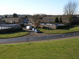
Hanworth is a southern suburb of Bracknell, originally part of the now-defunct civil parish of Easthampstead, in the English county of Berkshire. The Hanworth estate was built in the 1970s upon the site of the wooded Hanworth Plantation. It is bounded by Birch Hill to the east, Great Hollands to the north-west, Easthampstead and the Church Hill estate to the north and the Nine Mile Ride and Crown plantations at Crowthorne Woods to the south. The Iron Age hill fort of Caesar's Camp is basically at Hanworth, although it has been transferred to the parish of Crowthorne.
Crown Wood is a south-eastern estate of Bracknell in the English county of Berkshire, and formerly part of the parish of Winkfield.
Great Hollands is a suburb of Bracknell in Berkshire, England. It takes its name from a medieval field-name of Easthampstead parish, which it was previously in. Building of the estate began around 1967 as the town continued to expand.

Harmans Water is a suburb of Bracknell, in the English county of Berkshire, formerly part of the parish of Winkfield. It takes its name from Harman's Water Lake, long gone. Building of the estate began around 1960 and was the fourth and last estate to be built as part of the original plan for the new town.

Bullbrook is a suburb of Bracknell, in the English county of Berkshire, formerly part of the parish of Winkfield. It is named after the Bull Brook which runs through the area, although most of the brook now runs underground in culverts. Bullbrook is one of the earlier estates of Bracknell and was built in the late 1950s.

Popeswood is a village in Berkshire, England, near Bracknell. The village is within the civil parish of Binfield approximately 1.5 miles (2.4 km) west of Bracknell. The main part of Popeswood lies north of the B3408 west of Temple Park and south of Binfield village, with a smaller section south of the B3408 between Amen Corner and Farley Wood.
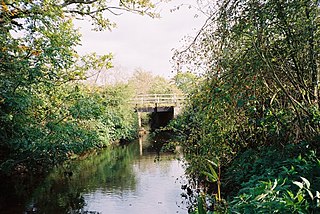
The Cut is a river in England that rises in North Ascot, Berkshire. It flows for around 14 miles (23 km), through the rural Northern Parishes of Winkfield, Warfield and Binfield in Bracknell Forest on its way down to Bray, where it meets the River Thames just above Queens Eyot on the reach below Bray Lock, having been joined by the Maidenhead Waterways.

Forest Park is a suburb of Bracknell, in Berkshire, England. It is part of the Swinley Forest ward and named after the Crown Estate of Swinley Forest. It was built in the late 1980s as the town continued to expand.

Jennett's Park is a suburb of Bracknell in the English county of Berkshire. It is a recent development with the first residents moving there in 2007. It is in the Binfield South & Jennett's Park ward of Bracknell Forest Council.
The 1976 Bracknell District Council election took place on 6 May 1976, to elect all 31 members in 16 wards for Bracknell District Council in England. The election was held on the same day as other local elections as part of the 1976 United Kingdom local elections. The Conservative Party ousted the one-term Labour Party council, winning all but 4 of the seats, with Labour group leader Bill Lindop losing his seat of Wildridings. The Liberal Party were able to hold onto their solitary seat in Crowthorne & Easthampstead. Despite leading the Conservative group into the election, Dorothy Benwell would be replaced by newly elected Tim Wood, who subsequently became leader of the council.

