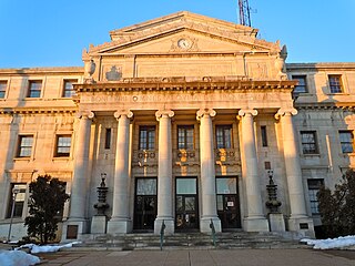
Delaware County, colloquially referred to as Delco, is a county in the Commonwealth of Pennsylvania. With a population of 576,830 as of the 2020 census, it is the fifth-most populous county in Pennsylvania and the third-smallest in area. The county was created on September 26, 1789, from part of Chester County and named for the Delaware River.

Aldan is a borough in Delaware County, Pennsylvania, United States. The population was 4,244 at the 2020 census.

Clifton Heights is a borough in Delaware County, Pennsylvania, United States, located on Darby Creek 5 miles (8 km) west of downtown Philadelphia. As of the 2020 census, the population was 6,863.

Colwyn is a borough in Delaware County, Pennsylvania, United States. The population was 2,546 at the 2010 census.
Darby is a borough in Delaware County, Pennsylvania, United States. The borough is located along Darby Creek 5 miles (8.0 km) southwest of Center City Philadelphia. The borough of Darby is distinct from the nearby municipality of Darby Township.

Drexel Hill is a neighborhood and census-designated place (CDP) located in Upper Darby Township, Pennsylvania, United States. The population was 29,181 at the 2020 census, an increase over 28,043 in 2010, and accounting for over one-third of Upper Darby Township's population.
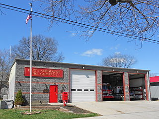
East Lansdowne is a borough in Delaware County, Pennsylvania, United States. The population was 2,668 at the 2010 census.

Lansdowne is a borough in Delaware County, Pennsylvania, United States, located 6 miles (10 km) southwest of Center City Philadelphia. It was named for the Marquess of Lansdowne. As of the 2010 census, the borough had a population of 10,620.

Middletown Township is a township in Delaware County, Pennsylvania, United States. The population was 15,807 at the 2010 census. The Pennsylvania State University has an undergraduate satellite campus called Penn State Brandywine located in the north-central portion of the township. Located outside of Philadelphia, it constitutes part of the Delaware Valley.

MillbourneBorough is a self-governing municipal borough in Delaware County, Pennsylvania, United States. As of the 2020 census, the population is 1,212. Millbourne borders Philadelphia along Cobbs Creek. The name "Millbourne" comes from the word Mill and "bourne" meaning creek. Millbourne, at over 17,000 people per square mile, is the most densely populated incorporated place in Pennsylvania, and 24th in the entire United States.

Ridley Park is a borough in Delaware County, Pennsylvania, United States. The population was 7,002 at the 2010 census. Ridley Park is the home of Boeing's CH-47 Chinook helicopter division.
Springfield Township, or simply Springfield, is a township in Delaware County in the U.S. state of Pennsylvania. The population was 25,070 at the 2020 census. Springfield is a suburb of Philadelphia, located about 4 miles (6.4 km) west of the city.

Swarthmore is a borough in Delaware County, Pennsylvania, United States. Swarthmore was originally named "Westdale" in honor of noted painter Benjamin West, who was one of the early residents of the town. The name was changed to "Swarthmore" after the establishment of Swarthmore College. The borough population was 6,194 as of the 2010 census.

Upper Darby Township, often shortened to Upper Darby, is a home rule township in Delaware County, Pennsylvania, United States. As of the 2020 census, the township had a total population of 85,681, making it the state's sixth-most populated municipality after Philadelphia, Pittsburgh, Allentown, Reading, and Erie. Upper Darby borders Philadelphia, the nation's sixth-most populous city, and constitutes part of the Delaware Valley, also known as the Philadelphia metropolitan area, the nation's seventh-largest metropolitan area.

Yeadon is a borough in Delaware County, Pennsylvania, United States. It borders the city of Philadelphia. The population was 11,443 at the 2010 census.

Darby Township is a township in Delaware County, Pennsylvania, United States. The population was 9,264 as of the 2010 census. It is home to both residential areas and expansive industrial districts. Darby Township is home to a diverse population and its industrial districts are popular among shipping companies for their proximity to Philadelphia International Airport. It also is known for being made up of two non-contiguous geographical areas, requiring one to pass through at least two neighboring municipalities to make it from one end of Darby Township to the other. Darby Township is a distinct municipality from the nearby and similarly named Darby Borough and Upper Darby Township.

Radnor Township, often called simply Radnor, is a first class township with home rule status in Delaware County, Pennsylvania, United States.
The Baltimore Pike was an auto trail connecting Baltimore, Maryland, with Philadelphia, Pennsylvania.
Penn Wood High School is a high school that occupies two campuses. One in Lansdowne, Pennsylvania, USA, and one in Yeadon, Pennsylvania, USA.

U.S. Route 13 (US 13) is a United States Numbered Highway running from Fayetteville, North Carolina, north to Morrisville, Pennsylvania. The route runs for 49.359 miles (79.436 km) through the Delaware Valley in the U.S. state of Pennsylvania. The route enters the state from Delaware in Marcus Hook, Delaware County. It continues northeast through Delaware County, passing through the city of Chester before heading through suburban areas along Chester Pike to Darby. US 13 enters the city of Philadelphia on Baltimore Avenue and runs through West Philadelphia to University City, where it turns north along several city streets before heading east across the Schuylkill River along Girard Avenue. The route turns north and heads to North Philadelphia, where it runs northeast along Hunting Park Avenue. US 13 becomes concurrent with US 1 on Roosevelt Boulevard, continuing into Northeast Philadelphia. US 13 splits southeast on a one-way pair of streets before heading northeast out of the city on Frankford Avenue. The route continues into Bucks County as Bristol Pike, heading northeast to Bristol, where it turns into a divided highway. US 13 becomes a freeway in Tullytown and continues north to its terminus at US 1 in Falls Township, near Morrisville. US 13 roughly parallels Interstate 95 (I-95) through its course in Pennsylvania.


