William R. Mason Regional Park, or as it is more commonly referred to, Mason Park, is a park in southern Irvine, California. It is one of the largest parks in Irvine and is traversed by trails.
William R. Mason Regional Park, or as it is more commonly referred to, Mason Park, is a park in southern Irvine, California. It is one of the largest parks in Irvine and is traversed by trails.
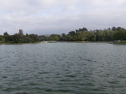
The first phase of the Mason Park, forty-five acres, opened to public use in 1973. A 50-acre (200,000 m2) second phase was completed in 1978 that included a 9.2-acre (37,000 m2) lake which has proven to be a popular attraction. [1]
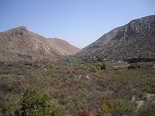
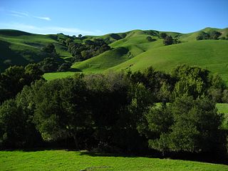
Mason Park straddles Culver Drive and is thus split into two parts. The east side of the park is a wilderness area. It features scrub-covered ground, traversed by a bike trail and a small creek. As it is located on the northern edge of the San Joaquin Hills, the terrain is rugged: the south edge is a large palisade, marking the edge of the park. The west side of Mason Park is more like a typical park than the east side. Though a ring of wilderness surrounds this side, it is mostly flat grassland, with an occasional hill or rise. An artificial lake about 900 ft (270 m) wide and 800 ft (240 m) long in the center of the park is often home to migrating birds and other local wildlife.
The park is named for former Irvine Company President William R. Mason, who headed the company from 1966 until his death at 54 in 1973.
Its numerous trails eventually lead to Ridgeline, a street that connects Turtle Rock Loop to University Drive.

Charles Lee Tilden Regional Park, also known as Tilden Park or Tilden, [], is a 2,079-acre (841 ha) regional park in the East Bay, part of the San Francisco Bay Area in California. It is between the Berkeley Hills and San Pablo Ridge. Its main entrance is near Kensington, Berkeley, and Richmond. The park is contiguous with Wildcat Canyon Regional Park.

The Angeles National Forest (ANF) of the U.S. Forest Service is located in the San Gabriel Mountains and Sierra Pelona Mountains, primarily within Los Angeles County in southern California. The ANF manages a majority of the San Gabriel Mountains National Monument.
Mission Trails Regional Park is a 7,220-acre (29.2 km2) open space preserve within the city of San Diego, California, established in 1974. It is the sixth-largest municipally owned park in the United States, and the largest in California.
At 47,527 acres (192.33 km2), Harriman State Park is the second largest state park in New York State. Located in Rockland and Orange counties 30 miles (48 km) north of New York City, it is a haven for hikers with over 200 miles (320 km) of hiking trails. The park is also known for its 31 lakes, multiple streams, public camping area, and great vistas. The park's hiking trails are currently maintained by volunteers from the New York - New Jersey Trail Conference.

Woodbridge is a large suburban housing development, begun in 1975 by the Irvine Company, in the central region of Irvine, California. It covers 2.65 square miles and has two large artificial lakes at its center. It contains four elementary schools, two middle schools, and Woodbridge High School. Most of the developments were completed by the mid-1990s. In 2013, development began on the first new housing tract in 15 years, consisting of 48 new homes called The Branches.

The Weminuche Wilderness is a wilderness area in southwest Colorado managed by the United States Forest Service as part of the San Juan National Forest on the west side of the Continental Divide and the Rio Grande National Forest on the east side of the divide. The Weminuche Wilderness was designated by Congress in 1975, and expanded by the Colorado Wilderness Acts of 1980 and 1993. It is located 4 miles (6.4 2), it is the largest wilderness area in the state of Colorado. Elevation in the wilderness ranges from 7,700 feet (2,300 m) along the Animas River to 14,093 feet (4,296 m) at the summit of Windom Peak.

The Trinity Alps Wilderness is a 525,627-acre (212,714 ha) designated wilderness located in northern California, roughly between Eureka and Redding. It is jointly administered by Shasta-Trinity, Klamath, and Six Rivers National Forests. About 4,623 acres (1,871 ha) are administered by the Bureau of Land Management. The wilderness is located in the Salmon and Scott Mountains, subranges of the Klamath Mountains region. The high, granitic and ultramafic peaks of the eastern half of the wilderness area are known as the Trinity Alps. Granite peaks at the core of the area are known as the White Trinities, reddish ultramafic peaks in the southeast are known as the Red Trinities, and the forested mountains in the western half of the wilderness are known as the Green Trinities.
Mile Square Regional Park is a park located in Fountain Valley, California, United States. It includes two lakes, three 18-hole golf courses, archery range, baseball and softball fields, picnic shelters, and a 20-acre (81,000 m2) urban nature area planted with California native plants, a 55-acre recreation center with tennis courts, basketball courts, racquetball courts, a gymnasium, the Kingston Boys & Girls Club, and a community center. This regional park was built on a naval landing field soon after the city was incorporated. James Kanno, one of America's first Japanese American mayors, led the effort to create the park.
Lake Bernard Frank, is a 54-acre (220,000 m2) reservoir on the North Branch of Rock Creek in Derwood, Maryland, U.S., just east of Rockville. In the late 1960s it was renamed after Bernard Frank, a wilderness activist and a co-founder of The Wilderness Society. The lake's boundaries are, approximately, Route 28, East Gude Drive, Avery Road, and Muncaster Mill Road. Lake Frank was created in 1966 as Lake Norbeck to aid in flood and sediment control, as well as to provide recreation. It has an earthen dam, installed in 1967, on its southern side. It was created as a sister lake to Lake Needwood. Lake Frank is owned by the Maryland-National Capital Park and Planning Commission (M–NCPPC).
University Hills is a housing development on the campus of the University of California, Irvine (UCI) in southern Irvine, California, United States, consisting of 1226 for-sale homes and 384 rental units. University Hills was developed by the Irvine Campus Housing Authority, a not-for-profit corporation under the control of the university. UC Irvine developed the area as "a way to compensate for high Orange County housing costs that can keep a recruit from accepting a job at the university."
Briones Regional Park is a 6,117-acre (24.75 km2) regional park in the East Bay Regional Park District (EBRPD) system, located in the Briones Hills of central Contra Costa County of the San Francisco Bay Area in California.

Founded in 1915, the Greater Los Angeles Area Council (GLAAC) (#033) served most of the City of Los Angeles as well as several other cities in the greater Los Angeles area. It was one of five Boy Scouts of America councils in Los Angeles County, California. Since its founding in 1915, the Los Angeles Area Council has brought its purpose and values to millions of youth. The Council served 54,567 youth in the Greater Los Angeles Area in 2008 alone.
Turtle Rock is a neighborhood in the south part of Irvine, Orange County, California, near Concordia University, Irvine and the University of California, Irvine. It is bounded to the north by University Drive and Mason Regional Park, to the east by the Strawberry Farms Golf Club and Ridgeline Drive, to the south by Shady Canyon Drive, and to the west by Culver Drive. Turtle Rock is one of the five "villages" originally forming Irvine; its 1967 founding is commemorated by a sculpture of a turtle in Turtle Rock Community Park, at the corner of Turtle Rock and Sunnyhill Drives. A two-lane internal loop road, Turtle Rock Drive, encircles the village and carries traffic between housing developments and the city's main streets.
The campus of the University of California, Irvine is known for its concentric layout with academic and service buildings arrayed around a central park, and for its Brutalist architecture.

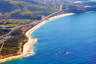
Laguna Canyon, also called Cañada de las Lagunas, is a gorge that cuts through the San Joaquin Hills in southern Orange County, California, in the United States, directly south of the city of Irvine. The canyon runs from northeast to southwest, and is drained on the north side by tributaries of San Diego Creek and on the south by Laguna Canyon Creek. It is deeper and more rugged on the southwestern end near Laguna Beach.
Quail Hill is a village in the southern part of Irvine, Orange County, California. It is one of the seven communities that belong to the University area of the City of Irvine. The village's name comes from a distinctive rock formation that adjoins 600 acres (2.4 km2) of open space. Located next to the 405 freeway, Quail Hill is close to major employment, entertainment and dining areas of the city. At the foot of Quail Hill there is the Quail Hill Loop Trail that provides public access to a natural surface trail.

Laguna Coast Wilderness Park is a 7,000-acre (2,800 ha) wilderness area in the San Joaquin Hills surrounding Laguna Beach, California. This park features coastal canyons, ridgeline views and the only natural lakes in Orange County, California. Trails are maintained for hiking and mountain biking with a wide range of difficulty, from beginner to expert. Most trails gain in height, reaching a maximum of 1,000 feet (300 m) in elevation. Several trails lead to downtown Laguna Beach.

Peters Canyon Regional Park is a regional park within the Orange County Regional Parks System in California. The park contains 354 acres of southern California wildlife, including coastal sage shrub, riparian, freshwater marsh, and grasslands, and is located within the boundaries of both Orange, California and Tustin, California. Peters Canyon was given to this city in 1992 by the Irvine Company who had used it previously for cattle grazing. The canyon is lined with a residential area on one side and open hills on the other. This canyon is commonly used by hikers, mountain bikers, and equestrians because of the trails that circumvent the 50 acre man-made lake, which was constructed by the Irvine Company in 1931, on the interior of the plot. The regional park is open from 7:00 AM to sunset every day of the week, save for the chance of rain or hazardous conditions, in which case the park will be closed for three days following the particular occurrence.
The Irvine Ranch Natural Landmarks are a collection of protected areas in Orange County, California in and around Irvine. They encompass almost 50,000 acres (20,000 ha) of land which was once a part of the Irvine Ranch owned by the Irvine Company. Almost 40,000 acres (16,000 ha) of the landmarks were designated a National Natural Landmark in 2006 and a California Natural Landmark in 2008.
Orange County Parks, more commonly abbreviated to OC Parks, is a government agency that maintains and oversees the public parks of Orange County, California. The agency operates both natural and manmade parks of the region. OC Parks is responsible for 60,000 acres (24,000 ha) of inland and coastal open space that collectively receives millions of visitors every year.
Coordinates: 33°39′22″N117°49′54″W / 33.6560°N 117.8318°W
| | This Orange County, California–related article is a stub. You can help Wikipedia by expanding it. |