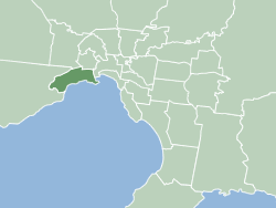
The City of Hobsons Bay is a local government area in Melbourne, Victoria, Australia. It comprises the south-western suburbs between 6 and 20 km from the Melbourne city centre.

The City of Wyndham is a local government area in Victoria, Australia in the outer south-western suburbs of Melbourne, within the Melbourne Metropolitan Area, between Melbourne and the regional city of Geelong. It has an area of 542 square kilometres (209 sq mi). The city had a population of 255,322 in June 2018. For the year to 2018 the City of Wyndham increased its population by 14,251, the largest number of any LGA in Victoria, as well as being the second most populous and the second fastest growing at a rate of 5.9 per cent.

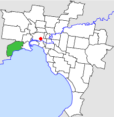
Altona is a suburb in Melbourne, Victoria, Australia, 13 km (8.1 mi) south-west of Melbourne's Central Business District, located within the City of Hobsons Bay local government area. Altona recorded a population of 11,490 at the 2021 census.

Newport is a suburb in Melbourne, Victoria, Australia, 10 km (6.2 mi) south-west of Melbourne's Central Business District, located within the City of Hobsons Bay local government area. Newport recorded a population of 13,658 at the 2021 census.

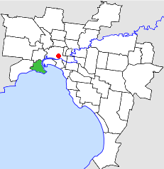
Williamstown is a suburb in Melbourne, Victoria, Australia, 11 km (6.8 mi) south-west of Melbourne's Central Business District, located within the City of Hobsons Bay local government area. Williamstown recorded a population of 14,407 at the 2021 census.
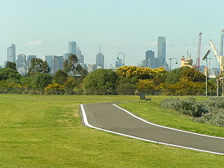
The Hobsons Bay Coastal Trail is a shared use path for cyclists and pedestrians, which follows the coast line of Hobsons Bay in the inner western suburbs in Melbourne, Victoria, Australia. The trail forms part of the western half of the Bayside Trail which encircles Port Phillip. It runs from the west side of the Westgate bridge, south and along the coast, finishing at the Skeleton Creek Trail in Sanctuary Lakes.

The Kororoit Creek Trail is a shared use path for cyclists and pedestrians, which follows the Kororoit Creek in the inner western suburbs of Melbourne, Victoria, Australia.
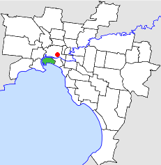
The City of Altona was a local government area about 13 kilometres (8 mi) west of Melbourne, the state capital of Victoria, Australia. The city covered an area of 40.18 square kilometres (15.51 sq mi), and existed from 1957 until 1994.
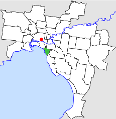
The City of Williamstown was a local government area about 10 kilometres (6 mi) southwest of Melbourne, the state capital of Victoria, Australia. The city covered an area of 14.50 square kilometres (5.60 sq mi), and existed from 1919 until 1994.

The City of Footscray was a local government area about 5 kilometres (3 mi) west of Melbourne, the state capital of Victoria, Australia. The city covered an area of 17.10 square kilometres (6.60 sq mi) and existed from 1859 until 1994. Its civic centre, after which it was named, was Footscray.

The City of Fitzroy was a local government area about 2 kilometres (1 mi) northeast of Melbourne, the state capital of Victoria, Australia. The city covered an area of 3.73 square kilometres (1.44 sq mi), making it the smallest municipality by land area in Victoria, and existed from 1858, until 1994.

The City of Richmond was a local government area about 2 kilometres (1 mi) east of Melbourne, the state capital of Victoria, Australia. The city covered an area of 6.12 square kilometres (2.36 sq mi), and existed from 1855 until 1994.
The City of Port Melbourne was a local government area about 4 kilometres (2 mi) southwest of Melbourne, the state capital of Victoria, Australia, on the south bank of the Yarra River. The city covered an area of 10.62 square kilometres (4.10 sq mi), and existed from 1860 until 1994.
The City of St Kilda was a local government area on Port Phillip, about 5 kilometres (3.1 mi) south of Melbourne, the state capital of Victoria, Australia. The city covered an area of 8.70 square kilometres (3.36 sq mi), and existed from 1855 until 1994.

The City of Brighton was a local government area about 10 kilometres (6.2 mi) south of Melbourne, the state capital of Victoria, Australia. The city covered an area of 13.48 square kilometres (5.20 sq mi), and existed from 1859 until 1994.

The Newport Railway Workshops is a facility in the Melbourne suburb of Newport, Australia, that builds, maintains and refurbishes railway rollingstock. It is located between the Williamstown and Werribee railway lines.

Altona Coastal Park, a 70 hectares intertidal and salt marsh area located 11 km from Melbourne CBD in the western suburb of Altona, is an important recreational and nature conservation area, providing habitats for a large biodiversity of flora and fauna. It is part of the Cheetham and Altona Important Bird Area.
The Truganina Coastal Parklands are located 15 km west of Melbourne CBD, on the shores of Port Phillip Bay, stretching from Altona to Altona Meadows and adjacent to the Cheetham Wetlands and the Point Cook Coastal Park. They were formed through the 'recycling' of more than 300 hectares of parks and former industrial land and are now the largest cluster of parks on Port Phillip Bay, interlinked by cycling and walking trails and featuring a surprisingly high diversity and abundance of landscapes, natural environment and recreational areas, including beachside recreation, picnic & barbecue facilities, grassfields and wildlife conservation areas. The wetlands form part of the Cheetham and Altona Important Bird Area.

Williamstown Racecourse was a horse racing track located at Altona, Victoria, Australia.
