Willoughby Hills, Ohio

Last updated

Willoughby Hills, Ohio
Squire's Castle 2.jpg
Nickname: 
The Bridge City
Motto: 
"Where the City Meets the Country"
OHMap-doton-Willoughby Hills.png
Location in Ohio
Map of Lake County Ohio Highlighting Willoughby Hills City.png
Location of Willoughby Hills in Lake County
Coordinates: 41°35′14″N81°26′00″W / 41.58722°N 81.43333°W / 41.58722; -81.43333
Country United States
State Ohio
County Lake
Founded1815 [1]
Incorporated1954
Area
[2]
  Total10.84 sq mi (28.09 km2)
  Land10.76 sq mi (27.87 km2)
  Water0.08 sq mi (0.21 km2)
Elevation
[3]
846 ft (244 m)
Population
 (2020)
  Total10,019
  Density931.05/sq mi (359.46/km2)
Time zone UTC-5 (EST)
  Summer (DST) UTC-4 (EDT)
ZIP code
44092 and 44094
Area code 440
FIPS code 39-85512 [4]
GNIS feature ID1086436 [3]
Website www.willoughbyhills-oh.gov

Willoughby Hills is a city in Lake County, Ohio, United States, along the Chagrin River. The population was 10,019 at the 2020 census. A suburb of Cleveland, it is part of the Cleveland metropolitan area.

Contents

Geography

According to the United States Census Bureau, the city has a total area of 10.82 square miles (28.02 km2), of which 10.73 square miles (27.79 km2) is land and 0.09 square miles (0.23 km2) is water. [5] Willoughby Hills borders Euclid and Richmond Heights on the west, Gates Mills, Highland Heights, and Mayfield Village on the south, Kirtland and Waite Hill on the east, and Wickliffe and Willoughby to the north.

Demographics

Historical population
CensusPop.Note
1960 4,241
1970 5,96940.7%
1980 8,61244.3%
1990 8,427−2.1%
2000 8,5952.0%
2010 9,48510.4%
2020 10,0195.6%
2021 (est.)9,970−0.5%
Sources: [4] [6] [7] [8]

88.3% spoke English, 3.7% Slovene, 3.1% Croatian, 1.1% Spanish, 1.1% Italian, and 1.1% Russian. [9]

Of the city's population over the age of 25, 35.5% held a bachelor's degree or higher. [10]

2010 census

As of the census [11] of 2010, there were 9,485 people, 4,398 households, and 2,602 families living in the city. The population density was 884.0 inhabitants per square mile (341.3/km2). There were 4,929 housing units at an average density of 459.4 per square mile (177.4/km2). The racial makeup of the city was 77.6% White, 16.1% African American, 4.3% Asian, 0.3% from other races, and 1.6% from two or more races. Hispanic or Latino of any race were 1.3% of the population.

There were 4,398 households, of which 23.0% had children under the age of 18 living with them, 44.6% were married couples living together, 10.4% had a female householder with no husband present, 4.1% had a male householder with no wife present, and 40.8% were non-families. 35.6% of all households were made up of individuals, and 10.8% had someone living alone who was 65 years of age or older. The average household size was 2.16 and the average family size was 2.80.

The median age in the city was 44.4 years. 18.6% of residents were under the age of 18; 8.2% were between the ages of 18 and 24; 24% were from 25 to 44; 31.1% were from 45 to 64; and 18.1% were 65 years of age or older. The gender makeup of the city was 48.1% male and 51.9% female.

2000 census

As of the census [4] of 2000, there were 8,595 people, 3,973 households, and 2,379 families living in the city. The population density was 798.4 inhabitants per square mile (308.3/km2). There were 4,292 housing units at an average density of 398.7 per square mile (153.9/km2). The racial makeup of the city was 88.84% White, 6.47% African American, 0.07% Native American, 3.55% Asian, 0.15% from other races, and 0.92% from two or more races. Hispanic or Latino of any race were 0.70% of the population. 15.5% were of German, 15.3% Italian, 11.1% Slovene, 8.8% Irish and 7.3% English ancestry according to Census 2000.

There were 3,973 households, out of which 20.9% had children under the age of 18 living with them, 49.2% were married couples living together, 7.4% had a female householder with no husband present, and 40.1% were non-families. 35.1% of all households were made up of individuals, and 11.5% had someone living alone who was 65 years of age or older. The average household size was 2.16 and the average family size was 2.82.

In the city the population was spread out, with 18.1% under the age of 18, 7.1% from 18 to 24, 28.4% from 25 to 44, 27.9% from 45 to 64, and 18.4% who were 65 years of age or older. The median age was 43 years. For every 100 females, there were 91.5 males. For every 100 females age 18 and over, there were 90.0 males.

The median income for a household in the city was $47,493, and the median income for a family was $60,397. Males had a median income of $47,190 versus $30,908 for females. The per capita income for the city was $26,688. About 1.7% of families and 3.4% of the population were below the poverty line, including 2.7% of those under age 18 and 2.7% of those age 65 or over.

Culture

Two notable buildings in Willoughby Hills are the Squire's Castle in the Cleveland Metroparks' North Chagrin Reservation and the Louis Penfield House, a house designed by Frank Lloyd Wright.

Education

The city is served by the Willoughby-Eastlake City School District. [12]

Willoughby Hills has a public library, a branch of Willoughby-Eastlake Public Library. [13]

Related Research Articles

<span class="mw-page-title-main">Lake County, Ohio</span> County in Ohio, United States

Lake County is a county in the U.S. state of Ohio. As of the 2020 census, the population was 232,603. Its county seat is Painesville, and its largest city is Mentor.

<span class="mw-page-title-main">Villa Hills, Kentucky</span> City in Kentucky, United States

Villa Hills is a home rule-class city in Kenton County, Kentucky along the Ohio River. The population was 7,310 at the 2020 census.

<span class="mw-page-title-main">Eastlake, Michigan</span> Village in Michigan, United States

Eastlake is a village in the U.S. state of Michigan. The population was 415 at the 2020 census. Located within Manistee County, the village sits across Manistee Lake from the city of Manistee.

<span class="mw-page-title-main">Mayfield, Ohio</span> Village in Ohio, United States

Mayfield is a village in eastern Cuyahoga County, Ohio, United States. A suburb of Cleveland, it is part of the Cleveland metropolitan area. The population was 3,356 at the 2020 census.

<span class="mw-page-title-main">Richmond Heights, Ohio</span> City in Ohio, United States

Richmond Heights is a city in Cuyahoga County, Ohio, United States. The population was 10,801 at the 2020 census. A suburb of Cleveland, it is part of the Cleveland metropolitan area.

<span class="mw-page-title-main">Seven Hills, Ohio</span> City in Ohio, United States

Seven Hills is a city in Cuyahoga County, Ohio, United States. The population was 11,720 at the 2020 census.

<span class="mw-page-title-main">Mount Healthy, Ohio</span> City in Ohio, United States

Mount Healthy is a city in Hamilton County, Ohio, United States. It is a suburb of Cincinnati. The population was 6,996 at the 2020 census.

<span class="mw-page-title-main">Indian Hill, Ohio</span> City in Ohio, United States

The Village of Indian Hill is a city in Hamilton County, Ohio, United States, and a suburb of the Greater Cincinnati area. The population was 6,087 at the 2020 census. Prior to 1970, Indian Hill was incorporated as a village, but under Ohio law became designated as a city once its population was verified as exceeding 5,000. The municipality then changed its name to add "Village" into the official name; legally it is "The City of The Village of Indian Hill". The Village of Indian Hill is served by the Indian Hill Exempted Village School District.

<span class="mw-page-title-main">Eastlake, Ohio</span> City in Ohio, United States

Eastlake is a city in Lake County, Ohio, United States. It takes its name from its location northeast of Cleveland, following along the shore of Lake Erie. The population was 17,670 at the 2020 census. The 2003 North America blackout stemmed from an Eastlake generating station going offline.

<span class="mw-page-title-main">Timberlake, Ohio</span> Village in Ohio, United States

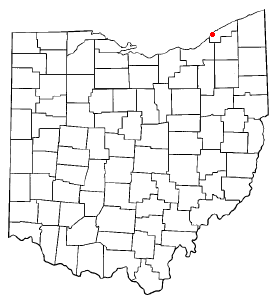
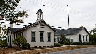
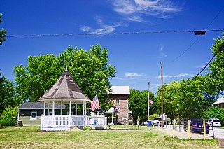
Timberlake is a village in Lake County, Ohio, United States. The population was 629 at the 2020 census.

<span class="mw-page-title-main">Wickliffe, Ohio</span> City in Ohio, United States

Wickliffe is a city in western Lake County, Ohio, United States. The population was 12,652 at the 2020 census. A suburb of Cleveland, it is part of the Cleveland metropolitan area.

<span class="mw-page-title-main">Willoughby, Ohio</span> City in Ohio, United States

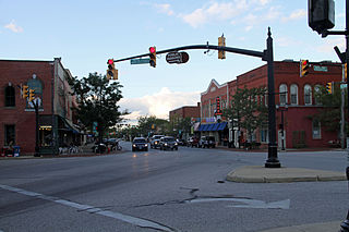
Willoughby is a city in Lake County, Ohio, United States, along the Chagrin River. The population was 23,959 at the time of the 2020 census. A suburb of Cleveland, it is part of the Cleveland metropolitan area.

<span class="mw-page-title-main">Willowick, Ohio</span> City in Ohio, United States

Willowick is a city in Lake County, Ohio, United States, on Lake Erie. The population was 14,204 at the 2020 census. A suburb of Cleveland, Willowick is served by a branch of the Willoughby-Eastlake Public Library. The city's name is a portmanteau of two adjacent cities, Willoughby and Wickliffe. As of 2022, the mayor of Willowick is Michael Vanni.

<span class="mw-page-title-main">Clayton, Ohio</span> City in Ohio, United States

Clayton is a city in Montgomery County, Ohio, United States. The population was 13,310 at the 2020 census. A suburb of Dayton, it is part of the Dayton metropolitan area.

<span class="mw-page-title-main">Franklin Park, Pennsylvania</span> Borough in Pennsylvania, United States

Franklin Park is a borough in Allegheny County, Pennsylvania, United States. The population was 15,479 at the 2020 census. It is a suburb of the Pittsburgh metropolitan area.

<span class="mw-page-title-main">Irwin, Pennsylvania</span> Borough in Pennsylvania, United States

Irwin is a borough in Westmoreland County, Pennsylvania, 22 miles (35 km) southeast of Pittsburgh. Some of the most extensive bituminous coal deposits in the commonwealth are located here. In the past, iron foundries, flour mills, car shops, facing and planing mills, electricals goods, and mirror factories provided employment to the residents. In 1900, the population numbered 2,452; it increased to 2,886 in 1910. The population was 3,973 at the 2010 census.

<span class="mw-page-title-main">Belmont, West Virginia</span> Town in West Virginia, United States

Belmont is a town in Pleasants County, West Virginia, United States. It is part of the Parkersburg–Vienna metropolitan area. The population was 872 at the 2020 census. Belmont was incorporated on April 19, 1946 by the Circuit Court of Pleasants County. The city was named for the beautiful hills in the area.

<span class="mw-page-title-main">Sharonville, Ohio</span> City in Ohio, United States

Sharonville is a city largely in Hamilton County in the U.S. state of Ohio. The population was 14,117 at the 2020 census.

<span class="mw-page-title-main">Cortland, Illinois</span> Town in Illinois, United States

Cortland is an incorporated town in DeKalb County, Illinois, United States. The population was 4,398 at the 2020 Census. It was previously 4,270 at the 2010 census, up from 2,066 in 2000. Because of its status as an incorporated town, Cortland has adopted the slogan, "The Third Largest Town in Illinois". Only the towns of Cicero and Normal are larger, in terms of population. Most municipalities in Illinois are defined as "cities" or "villages."

<span class="mw-page-title-main">Tremont City, Ohio</span> Village in Ohio, United States

Tremont City is a village in Clark County, Ohio, United States. The population was 352 at the 2020 census. The village is part of the Springfield, Ohio Metropolitan Statistical Area.

References

  1. ":: City of Willoughby Hills".
  2. "ArcGIS REST Services Directory". United States Census Bureau. Retrieved September 20, 2022.
  3. 1 2 U.S. Geological Survey Geographic Names Information System: Willoughby Hills, Ohio
  4. 1 2 3 "U.S. Census website". United States Census Bureau . Retrieved January 31, 2008.
  5. "US Gazetteer files 2010". United States Census Bureau . Retrieved January 6, 2013.
  6. "Number of Inhabitants: Ohio" (PDF). 18th Census of the United States. U.S. Census Bureau. 1960. Retrieved May 17, 2020.
  7. "Ohio: Population and Housing Unit Counts" (PDF). U.S. Census Bureau. Retrieved November 22, 2013.
  8. "Willoughby Hills city, Ohio". census.gov. Retrieved July 7, 2022.
  9. "Data Center Results".
  10. "Willoughby Hills (City) QuickFacts from the US Census Bureau". Archived from the original on August 9, 2014. Retrieved September 24, 2014.
  11. "U.S. Census website". United States Census Bureau . Retrieved January 6, 2013.
  12. "Schools". City of Willoughby Hills. Retrieved February 26, 2018.
  13. "Locations and Hours". Willoughby-Eastlake Public Library. Retrieved February 26, 2018.