
Oregon Country was a large region of the Pacific Northwest of North America that was subject to a long dispute between the United Kingdom and the United States in the early 19th century. The boundaries of the area, which had been created by the Treaty of 1818 without recognizing indigenous claims to the area, consisted of the land north of 42° N latitude, south of 54°40′ N latitude, and west of the Rocky Mountains down to the Pacific Ocean and east to the Continental Divide. Article III of the 1818 treaty gave joint control to both nations for ten years, allowed land to be claimed, and guaranteed free navigation to all mercantile trade. However, both countries disputed the terms of the international treaty. Oregon Country was the American name while the British used Columbia District for the region. Meanwhile, Indigenous nations had lived in the area since time immemorial, though with little legal recognition in the American and British legal systems. Evidence along the Salmon River shows people lived there at least 16,000 years ago, and may have populated the continent after migrating along the Pacific Coast, then following up the Columbia River into the interior.

Invermere is a community in eastern British Columbia, Canada, near the border of Alberta. It is the hub of the Columbia Valley between Golden to the north and Cranbrook to the south. Invermere sits on the northwest shore of Windermere Lake and is a popular summer destination for visitors and second home owners from Edmonton and Calgary.
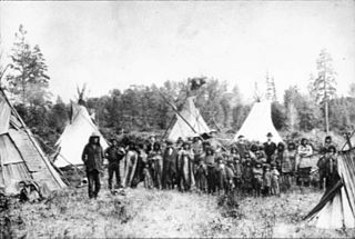
The Kutenai, also known as the Ktunaxa, Ksanka, Kootenay and Kootenai, are an indigenous people of Canada and the United States. Kutenai bands live in southeastern British Columbia, northern Idaho, and western Montana. The Kutenai language is a language isolate, thus unrelated to the languages of neighboring peoples or any other known language.

The Cariboo is an intermontane region of British Columbia, Canada, centered on a plateau stretching from Fraser Canyon to the Cariboo Mountains. The name is a reference to the caribou that were once abundant in the region.
Laidlaw is an unincorporated settlement in the Upper Fraser Valley region of British Columbia, Canada, located just west of the westernmost boundary of Hope, British Columbia on the south side of the Fraser River and along the Trans-Canada Highway.

The Purcell Mountains are a mountain range in southeastern British Columbia, Canada. They are a subrange of the Columbia Mountains, which includes the Selkirk, Monashee, and Cariboo Mountains. They are located on the west side of the Rocky Mountain Trench in the area of the Columbia Valley, and on the east side of the valley of Kootenay Lake and the Duncan River. The only large settlements in the mountains are the Panorama Ski Resort and Kicking Horse Resort, adjacent to the Columbia Valley towns of Invermere and Golden, though there are small settlements, such as Yahk and Moyie along the Crowsnest Highway, and residential rural areas dependent on the cities of Creston, Kimberley and Cranbrook, which are located adjacent to the range.

The Columbia Valley is the name used for a region in the Rocky Mountain Trench near the headwaters of the Columbia River between the town of Golden and the Canal Flats. The main hub of the valley is the town of Invermere. Other towns include Radium Hot Springs, Windermere and Fairmont Hot Springs. The Panorama Ski Resort is located near the valley.
Kootanae House, also spelled Kootenae House, was a North West Company fur trading post built by Jaco Finlay under the direction of David Thompson near present-day Invermere, British Columbia in 1807. It was abandoned in 1812. In 1808 Thompson reckoned its location as 50°32′12″N115°56′15″W. The actual location is Kootenae House National Historic Site, located at 50.526624°N 116.045440°W.
Tkʼemlúps te Secwépemc, abbreviated TteS and previously known as the Kamloops Indian Band, is a First Nations government within the Shuswap Nation Tribal Council, which represents ten of the seventeen Secwepemc band governments, all in the southern Central Interior region, spanning the Thompson and Shuswap districts. It is one of the largest of the 17 groups into which the Secwepemc (Shuswap) nation was divided when the Colony of British Columbia established an Indian reserve system in the 1860s.

Lake Windermere is a very large widening in the Columbia River. The village of Windermere is located on the east side of the lake, and the larger town of Invermere is located on the lake's northwestern corner. The average depth of the lake is only 15 feet (4.6 m).

The Columbia District was a fur trading district in the Pacific Northwest region of British North America in the 19th century. Much of its territory overlapped with the disputed Oregon Country. It was explored by the North West Company between 1793 and 1811, and established as an operating fur district around 1810. The North West Company was absorbed into the Hudson's Bay Company in 1821 under which the Columbia District became known as the Columbia Department. The Oregon Treaty of 1846 marked the effective end of the Hudson's Bay Company's Columbia Department.
McLeod Lake is an unincorporated community located on Highway 97 in northern British Columbia, Canada, 140 km (87 mi) north of Prince George. It is notable for being the first continuously inhabited European settlement established west of the Rocky Mountains in present-day Canada.
James Chabot Provincial Park is a provincial park in British Columbia, Canada. Formerly Athalmer Beach Provincial Park, it is located in Invermere at the northeast end of Windermere Lake in the Columbia Valley region of the East Kootenay. Windermere Lake Provincial Park is located at the lake's southwestern end.
Telegraph Cove is a community of about 20 inhabitants, on Vancouver Island in British Columbia, Canada, located approximately 210 kilometres (130 mi) northwest of Campbell River. It is a former fishing and cannery village that has become a launch point for eco-tourism. It shares the inlet with Beaver Cove which is 3 km (2 mi) up the inlet.

Mansons Landing is an unincorporated community near the southern tip of Cortes Island, British Columbia, Canada.
The Shuswap Indian Reserve is a First Nations reserve in the Columbia Valley region of British Columbia, Canada, located on the left bank of the Columbia River, one mile (1.6 km) north of Invermere. The reserve is the home reserve of the Shuswap Indian Band, a band government of the Secwepemc (Shuswap) people and a member government of the Shuswap Nation Tribal Council and also of the Ktunaxa Kinbasket Tribal Council in alliance with nearby bands of the Ktunaxa people.

Jumbo Glacier, also known as Jumbo, was a mountain resort municipality within the Regional District of East Kootenay in southeast British Columbia, Canada between 2013 and 2021. It was approximately 55 km (34 mi) west of Invermere near the Commander Glacier and around the headwaters of Jumbo Creek in the Purcell Range of the Columbia Mountains.

The Raush River is a tributary of the Fraser River in British Columbia, Canada. It drains a watershed of approximately 100,000 hectares on the eastern flanks of the Cariboo Mountains, a sub-range of the Columbia Mountains. The river joins the Fraser near the community of Dunster in the Robson Valley. The river's name is the result of a transcription error; it was originally called the Rivière au Shuswap, this was recorded on some maps as R.auSh., which then became Raush on official maps. Its source is the Raush Glacier, and major tributary creeks include Black Martin and Quanstrom.
Located in the southern part of British Columbia, Columbia National Wildlife Area was established to protect its wetlands and as a temporary home for migratory birds travelling to South America. The National Wildlife Area (NWA) is divided into four unit areas: Wilmer, Spillimacheen, Brisco and Harrogate, which are home to many diverse species of animals and plants which are significant in Canada.
Scotch Creek is a stream in the British Columbia Interior of Canada, located on the north side of Shuswap Lake. It is part of the Thompson River watershed, which is a tributary to the Fraser River. It flows from the Shuswap Highlands into Shuswap Lake just west of the community of Scotch Creek. It was named for Scottish gold prospectors who worked the creek with placer mining operations in the 1860s. The creek's headwaters are near Pukeshun Mountain, and flow southwest and south for 56.5 kilometres (35.1 mi). The creek supports sockeye salmon, which breed in the creek during a small salmon run in the autumn. The salmon run usually sees between 1,000 and 18,000 fish return to the river.