Related Research Articles

Haxby is a town and civil parish in the City of York district of North Yorkshire, England. According to the 2001 Census, the parish had a population of 8,754, which reduced to 8,428 at the 2011 Census.
Frodsham is a market town, civil parish, and electoral ward in the unitary authority of Cheshire West and Chester and the ceremonial county of Cheshire, England. Its population in 2021 was 9,300. It is 16 miles (26 km) south of Liverpool and 28 miles (45 km) southwest of Manchester. The River Weaver runs to its northeast and on the west it overlooks the estuary of the River Mersey. The A56 road and the Chester–Manchester railway line pass through the town, and the M56 motorway passes to the northwest.
Local government in Wales is primarily undertaken by the twenty-two principal councils. The councils are unitary authorities, meaning they are responsible for providing local government services within their principal area, including education, social work, environmental protection, and most highway maintenance. The principal areas are divided into communities, most of which have an elected community council. The services provided by community councils vary, but they will typically maintain public spaces and facilities. Local councils in Wales are elected; the most recent local elections in Wales took place in 2022, and the next are due to take place in 2027.
A parish council is a civil local authority found in England, which is the lowest tier of local government. They are elected corporate bodies, with variable tax raising powers, and they carry out beneficial public activities in geographical areas known as civil parishes. There are about 10,480 parish and town councils in England. Parish councils may be known by different styles, they may resolve to call themselves a town council, village council, community council, neighbourhood council, or if the parish has city status, it may call itself a city council. However their powers and duties are the same whatever name they carry.

North Kesteven is a local government district in Lincolnshire, England. The council is based in Sleaford. The district also contains the town of North Hykeham, which adjoins the neighbouring city of Lincoln, along with numerous villages and surrounding rural areas.

Withington is a suburb of Manchester, Greater Manchester, England. Historically part of Lancashire, it lies 4 miles (6.4 km) from Manchester city centre, about 0.4 miles (0.6 km) south of Fallowfield, 0.5 miles (0.8 km) north-east of Didsbury and also 1 mile (1.6 km) east of Chorlton-cum-Hardy. Withington has a population of just over 14,000 people, reducing at the 2011 census to 13,422.

Macclesfield was, from 1974 to 2009, a local government district with borough status in Cheshire, England. It included the towns of Bollington, Knutsford, Macclesfield and Wilmslow and within its wider area the villages and hamlets of Adlington, Disley, Gawsworth, Kerridge, Pott Shrigley, Poynton, Prestbury, Rainow, Styal, Sutton and Tytherington.
The Metropolitan Borough of Wigan is a metropolitan borough of Greater Manchester, England. It is named after its largest town, Wigan but covers a far larger area which includes the towns of Atherton, Ashton-in-Makerfield, Golborne, Hindley, Ince-in-Makerfield, Leigh and Tyldesley. The borough also covers the villages and suburbs of Abram, Aspull, Astley, Bryn, Hindley Green, Lowton, Mosley Common, Orrell, Pemberton, Shevington, Standish, Winstanley and Worsley Mesnes. The borough is also the second-most populous district in Greater Manchester.

The Borough of Burnley is a local government district with the borough status in Lancashire, England. It has an area of 42.9 square miles (111 km2) and a population of 95,553 (2022), and is named after its largest town, Burnley. The borough also contains the town of Padiham along with several villages and surrounding rural areas.

A civil parish is a country subdivision, forming the lowest unit of local government in England. There are 333 civil parishes in the ceremonial county of Cheshire, most of the county being parished. Cheshire East unitary authority is entirely parished. At the 2001 census, there were 565,259 people living in 332 parishes, accounting for 57.5 per cent of the county's population.

Tatton is a constituency in Cheshire represented in the House of Commons of the UK Parliament since 2017 by Esther McVey, a Conservative.

Guilden Sutton is a civil parish and village in the unitary authority of Cheshire West and Chester and the ceremonial county of Cheshire, England. The village lies approximately 3 miles (5 km) to the east of Chester and is south of the village of Mickle Trafford. The community consists of a church, a primary school, a post office, a pub, a village hall and several local businesses.
Richmond Hill City Council is the governing body for the Canadian city of Richmond Hill, Ontario. Council serves a four-year term, after which a new council is elected by qualified electors in Richmond Hill. Richmond Hill City Council consists of a Mayor, six Ward Councillors and two Regional and Local Councillors. The mayor and the regional and local councillors additionally serve on the York Regional Council representing the interests of the residents of Richmond Hill.

Haslington is a village and civil parish in the unitary authority of Cheshire East and the ceremonial county of Cheshire, England. It lies about 2 miles (3.2 km) north-east of the much larger railway town of Crewe and approximately 4 miles (6.4 km) south of Sandbach. The village was originally bisected by the A534 road that links Crewe with Sandbach, however, this road has now been re-routed to bypass the village to the north-west. The village is also a close neighbour to a number of small towns and villages, and is approximately 6 miles (9.7 km) from the Elizabethan market town of Nantwich.

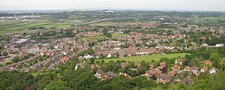
Handforth is a town and civil parish in Cheshire, England, 9 miles (14 km) south of Manchester city centre. The population at the 2011 census was 6,266. In the 1960s and 1970s, two overspill housing estates, Spath Lane in Handforth, and Colshaw Farm nearby in Wilmslow, were built to re-house people from inner city Manchester. It lies between Wilmslow, Heald Green, Stanley Green and Styal and forms part of the Greater Manchester Built-up Area.

Cheshire East is a unitary authority area with borough status in Cheshire, England. The local authority is Cheshire East Council, which is based in the town of Sandbach. Other towns within the area include Crewe, Macclesfield, Congleton, Wilmslow, Nantwich, Poynton, Knutsford, Alsager, Bollington and Handforth.

Cheshire East Council is the local authority for Cheshire East, a local government district with borough status in the ceremonial county of Cheshire, England. The council is a unitary authority, being a district council which also performs the functions of a county council. It has been under no overall control since 2019, being run by a coalition of Labour, local parties and independent councillors, led by Labour councillor Sam Corcoran. The council's main offices are in Sandbach, but there are plans to move them to Crewe.

Knutsford Town Council is the town council for the Cheshire Market Town of Knutsford. It was established in 1974 as a successor council to the Knutsford Urban District Council. The last full council elections were held in May 2023, four wards were uncontested whilst a poll was held in the fifth. The elections saw the Conservatives lose control of the council with 10 Independent councillors elected and five Conservatives. The council is split into five wards, Nether (3), Norbury Booths (3), St John's Wood (3), Cross Town (3) and Bexton and Town Centre (3).
Tewkesbury Town Council is a local council covering the parish of Tewkesbury, Gloucestershire. It is a successor parish to the Tewkesbury Municipal Borough Council that existed prior to the reorganisation of English Local Government in April 1974. The Town Council in its original form was constituted by the Local Government Order 1973, where Tewkesbury Town is listed in Schedule Part 1.

Handforth Town Council is the civil parish council of Handforth, Cheshire, England.
References
- ↑ "Councillors". Wilmslow Town Council. Archived from the original on 1 June 2021. Retrieved 1 June 2021.
- ↑ "Parish and Town Councils Election May 2019 -Tabley to Wybunbury". Cheshire East Council . Archived from the original on 1 June 2021.
- ↑ "Town Council". Wilmslow Town Council. Archived from the original on 15 August 2014.
| | This article related to government in the United Kingdom or its constituent countries is a stub. You can help Wikipedia by expanding it. |