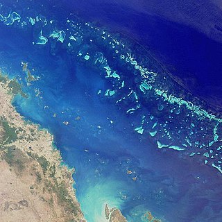
The Great Barrier Reef is the world's largest coral reef system composed of over 2,900 individual reefs and 900 islands stretching for over 2,300 kilometres (1,400 mi) over an area of approximately 344,400 square kilometres (133,000 sq mi). The reef is located in the Coral Sea, off the coast of Queensland, Australia. The Great Barrier Reef can be seen from outer space and is the world's biggest single structure made by living organisms. This reef structure is composed of and built by billions of tiny organisms, known as coral polyps. It supports a wide diversity of life and was selected as a World Heritage Site in 1981. CNN labelled it one of the seven natural wonders of the world in 1997. Australian World Heritage places included it in its list in 2007. The Queensland National Trust named it a state icon of Queensland in 2006.

Capricornia Cays is both a national park and a scientific national park in Queensland (Australia), located 486 km and 472 km north of the state capital Brisbane respectively. Collectively they comprise 241 ha of coral cays.

Green Island National Park is a protected area declared over a small coral cay of Green Island, Cairns Region, Queensland, Australia. It is known to the local Gungganyji Aboriginal peoples as Dabuukji. The Gungganyji people used the island as an initiation ground.

Lizard Island is an island on the Great Barrier Reef in Queensland (Australia), 1624 km northwest of Brisbane and part of the Lizard Island Group that also includes Palfrey Island. It is part of the Lizard Island National Park. Lizard Island is within the locality of Lizard in the Cook Shire.

The Coral Sea is a marginal sea of the South Pacific off the northeast coast of Australia, and classified as an interim Australian bioregion. The Coral Sea extends 2,000 kilometres (1,200 mi) down the Australian northeast coast. The sea was the location for the Battle of the Coral Sea, a major confrontation during World War II between the navies of the Empire of Japan, and the United States and Australia.

Heron Island is a coral cay located near the Tropic of Capricorn in the southern Great Barrier Reef, 80 kilometres north-east of Gladstone Park, Queensland, Australia, and 460 km (290 mi) north-north-west of the state capital Brisbane. The island is situated on the leeward (western) side of Heron Reef, a fringing platform reef of significant biodiversity, supporting around 900 of the 1,500 fish species and 72% of the coral species found on the Great Barrier Reef. During the summer months Heron Island is also home to over 200,000 birds including Noddy Terns and Mutton Birds.
Lady Elliot Island is the southernmost coral cay of the Great Barrier Reef, Australia. The island lies 46 nautical miles north-east of Bundaberg and covers an area of approximately 45 hectares. It is part of the Capricorn and Bunker Group of islands and is owned by the Commonwealth of Australia. The island is home to a small eco resort and an airstrip, which is serviced daily by flights from Bundaberg, Hervey Bay, Brisbane and the Gold Coast.

North West Island is a coral cay in the southern Great Barrier Reef, located 75 kilometres northeast of Gladstone, Queensland. North West Island forms part of Capricornia Cays National Park and with an area of 1.05 km2, the island is the second largest coral cay in the Great Barrier Reef. It is part of the Capricornia Cays Important Bird Area.

Lady Musgrave Island is a 14 hectares coral cay on Australia's Great Barrier Reef, with a 1,192 hectares surrounding reef. The island is the second southernmost island in the Great Barrier Reef chain of islands. The Island is named after Lady Lucinda Musgrave, the wife of Sir Anthony Musgrave, a colonial governor of Queensland.
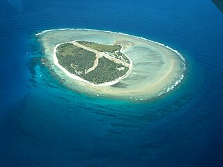
Raine Island is a vegetated coral cay 32 hectares in total area situated on the outer edges of the Great Barrier Reef off north-eastern Australia. It lies approximately 620 km (390 mi) north-northwest of Cairns in Queensland, about 120 kilometres (75 mi) east-north-east of Cape Grenville on the Cape York Peninsula.
The islands and reefs of the Capricorn and Bunker Group are situated astride the Tropic of Capricorn at the southern end of the Great Barrier Reef, approximately 80 kilometres east of Gladstone, which is situated on the central coast of the Gladstone Region, Queensland, Australia.
Fairfax Islands is a pair of small coral cays, both of which have been used as a bombing range. They are located near the Tropic of Capricorn in the southern Great Barrier Reef, 113 kilometres (70 mi) due east of Gladstone, Queensland, Australia, and 405 km (252 mi) north of the state capital Brisbane.
Hoskyn Islands is a pair of small coral cays. They are located near the Tropic of Capricorn in the southern Great Barrier Reef, 107 km due east of Gladstone, Queensland, Australia, and 412 km north of the state capital Brisbane.
One Tree Island is a small coral cay. It is located near the Tropic of Capricorn in the southern Great Barrier Reef, 96 km due east nor east of Gladstone, Queensland, Australia, and 450 km north of the state capital Brisbane. The island is part of the Great Barrier Reef chain of islands, and is part of the Capricorn and Bunker Group of island and forms part of the Capricornia Cays National Park. It is also part of the Capricornia Cays Important Bird Area.
Wreck Island is a small coral cay. It is located near the Tropic of Capricorn in the southern Great Barrier Reef, 93 km due north east of Gladstone, Queensland, Australia, and 460 km north of the state capital Brisbane.
Tryon Island is a coral cay located in the southern Great Barrier Reef, 86 km northeast of Gladstone, Queensland, Australia, and 465 km north of the state capital Brisbane. The island is a protected area and forms part of Capricornia Cays National Park. It is part of the Capricornia Cays Important Bird Area. The cay covers an area of 0.21 square kilometres and is surrounded by a coral reef that is partially exposed at low-tide.

The Capricorn silvereye, also known as the Capricorn white-eye or green-headed white-eye, is a small greenish bird in the Zosteropidae or white-eye family. It is a subspecies of the silvereye that occurs on islands off the coast of Queensland in north-eastern Australia, and which is sometimes considered to be a full species.
Erskine Island is a small coral cay in the southern Great Barrier Reef, located 60 kilometres northeast of Gladstone, Queensland and 17 km west-south-west of Heron Island. It is part of the Capricornia Cays National Park and of the Capricornia Cays Important Bird Area.
Masthead Island is a coral cay located in the southern Great Barrier Reef, 60 kilometres northeast of Gladstone, Queensland. The island is a protected area and forms part of Capricornia Cays National Park. Masthead Island is one of the most undisturbed cays in the national park because human and feral animal impacts have been rare. The cay covers an area of 0.45 square kilometres (0.17 sq

Heron Island Research Station is a marine research station located on Heron Island, an island within the Great Barrier Reef Marine Park, 80 km from Gladstone, off the coast of Queensland, Australia. It is located at the leeward end of a coral cay on a 10 x 5 kilometre platform reef. Although the island had been used as a turtle cannery in the 1920s, after this was abandoned, it was taken over as a resort in the 1930s, by Captain Christian Poulsen. A number of researchers travelled to the island from the 1930s using the resort facilities. The island became a National Park in 1943, and following the end of World War II, saw the first groups of university students from the University of Queensland arrive. Today the island is divided into three sections - the resort, research station and National Park.

