Windsor Creek

Last updated
Windsor Creek
stream
WindsorCreek3235.jpg
Country United States
State California
Region Sonoma County
Tributaries
 - leftPool Creek
City Windsor, California
Source
 - location5 mi (8 km) southeast of Healdsburg, California
 - coordinates 38°35′26″N122°47′38″W / 38.59056°N 122.79389°W / 38.59056; -122.79389   [1]
Mouth Mark West Creek
 - location3 mi (5 km) northeast of Forestville
 - coordinates 38°29′48″N122°50′58″W / 38.49667°N 122.84944°W / 38.49667; -122.84944 Coordinates: 38°29′48″N122°50′58″W / 38.49667°N 122.84944°W / 38.49667; -122.84944   [1]
Relief map of California.png
Red pog.svg
Location of the mouth in California

Windsor Creek is an 8.8-mile-long (14.2 km) [2] southward-flowing stream in Sonoma County, California, United States, which rises near Healdsburg, California and feeds into Mark West Creek west of the Sonoma County Airport. Its waters reach the Pacific Ocean by way of the Russian River.

Stream A body of surface water flowing down a channel

A stream is a body of water with surface water flowing within the bed and banks of a channel. The stream encompasses surface and groundwater fluxes that respond to geological, geomorphological, hydrological and biotic controls.

Sonoma County, California County in California, United States

Sonoma County is a county in the U.S. state of California. As of the 2010 United States Census, its population was 483,878. Its county seat and largest city is Santa Rosa. It is to the north of Marin County and the south of Mendocino County. It is west of Napa County and Lake County.

Healdsburg, California City in California, United States

Healdsburg is a city located in Sonoma County, in California's Wine Country. As of the 2010 United States Census, the city had a population of 11,254. Healdsburg is a small tourist-oriented town in northern Sonoma County. Due to its three most important wine-producing regions, Healdsburg has been continuously awarded one of the top 10 small towns in America and is home to three of the top wineries in the United States.

Contents

Course

Windsor Creek rises about 5 miles (8 km) southeast of Healdsburg. It descends southward into the town of Windsor, paralleling Brooks Road to Hiram Lewis Park. It parallels Brooks Road South to U.S. Route 101, crossing under the freeway at milepost 29.5. It continues southwest through farmland to a confluence with Pool Creek east of Pratt Road. From there, it flows south to empty into Mark West Creek about 3 miles (5 km) northeast of Forestville.

Windsor, California Town in California in the United States

Windsor is an incorporated town in Sonoma County, California, United States. The town is 9 miles north of Santa Rosa and 63 miles north of San Francisco. The population was 26,801 as of the 2010 census.

U.S. Route 101 highway in the United States

U.S. Route 101, or U.S. Highway 101 (US 101) is a north–south United States Numbered Highway that runs through the states of California, Oregon, and Washington, on the West Coast of the United States. It is also known as El Camino Real where its route along the southern and central California coast approximates the old trail which linked the Spanish missions, pueblos, and presidios. It merges at some points with California State Route 1 (SR 1).

Agricultural land land used for agricultural purposes

Agricultural land is typically land devoted to agriculture, the systematic and controlled use of other forms of life—particularly the rearing of livestock and production of crops—to produce food for humans. It is thus generally synonymous with both farmland or cropland, as well as pasture or rangeland.

Watershed

The watershed is about 25 square miles, with a maximum elevation of about 800 feet and a minimum elevation of about 50 feet. The creek is seasonal and is generally dry during the summer months. With increased urbanization in the Windsor area, some parts of the creek retain water in isolated pools through the summer, due to runoff from sprinklers and other urban sources. [3]

Pollution

The Community Clean Water Institute (CCWI) monitors pollutants in Windsor Creek and other Sonoma County streams. Their sampling showed that Windsor creek exceeded the North Coast Basin Plan Objectives for conductivity and dissolved oxygen in 2006. [4] CCWI has also issued alerts for nitrates in Windsor Creek. [5]

Bridges

Windsor Creek is crossed by at least five bridges: [6]

See also

Related Research Articles

Lake Sonoma reservoir in Sonoma County, California

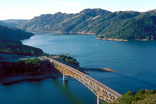
Lake Sonoma is a reservoir west of Healdsburg in northern Sonoma County, California, created by the construction of Warm Springs Dam. Access from U.S. Route 101 is by way of Dry Creek Road from Healdsburg.

Petaluma River river in California

The Petaluma River is a river in the California counties of Sonoma and Marin that becomes a tidal slough for the majority of its length. The headwaters are in the area southwest of Cotati. The flow is generally southward through Petaluma's old town, where the waterway becomes navigable, and then flows another 10 mi (16 km) through tidal marshes before emptying into the northwest corner of San Pablo Bay.

Russian River (California) river in California

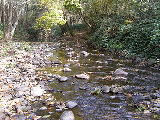
The Russian River is a southward-flowing river that drains 1,485 sq mi (3,850 km2) of Sonoma and Mendocino counties in Northern California. With an annual average discharge of approximately 1,600,000 acre feet (2.0 km3), it is the second-largest river flowing through the nine-county Greater San Francisco Bay Area, with a mainstem 110 mi (180 km) long.

Matanzas Creek stream in California

Matanzas Creek is an 11.4-mile-long (18.3 km) year-round stream in Sonoma County, California, United States, a tributary of Santa Rosa Creek.

Santa Rosa Creek stream in California

Santa Rosa Creek is a 22-mile-long (35 km) stream in Sonoma County, California, which rises on Hood Mountain and discharges to the Laguna de Santa Rosa by way of the Santa Rosa Flood Control Channel. This article covers both the creek and the channel.

Laguna de Santa Rosa wetland in Sonoma County, California, USA

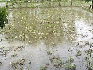
The Laguna de Santa Rosa is a 22-mile-long (35 km) wetland complex that drains a 254-square-mile (660 km2) watershed encompassing most of the Santa Rosa Plain in Sonoma County, California, United States.

Yulupa Creek stream in California

Yulupa Creek is a 2.8-mile-long (4.5 km) southeast-flowing perennial stream that rises on the southeastern flanks of the northern Sonoma Mountains in Sonoma County, California, United States. This creek, which drains the eastern slopes of Bennett Mountain, is tributary to Sonoma Creek, which in turn discharges to San Pablo Bay.

Americano Creek stream in California

Americano Creek is a 7.5-mile (12 km) long westward-flowing stream in the California counties of Sonoma and Marin. It flows into the Estero Americano, a 9.2 mi (15 km) long estuary, and thence to the Pacific Ocean. This article covers both watercourses.

Mark West Creek stream in California

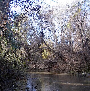
Mark West Creek is a 29.9-mile-long (48.1 km) stream that rises in the Mayacamas Mountains of Sonoma County, California, United States. Tributaries of Mark West Creek include Porter Creek and Hummingbird Creek, both of which originate in the same mountain range. Discharge waters of Mark West Creek reach the Russian River after a confluence with the Laguna de Santa Rosa. The Community Clean Water Institute has developed a program for monitoring pollutants in Mark West Creek.

Austin Creek stream in Sonoma County, California

Austin Creek is a 16.0-mile-long (25.7 km) southward-flowing stream in the mountains of western Sonoma County, California which empties into the Russian River about 4 miles (6 km) from the Pacific Ocean.

Maacama Creek stream in California

Maacama Creek is a 7.3-mile-long (11.7 km) stream in northern Sonoma County, California, U.S.A., which empties into the Russian River near the city of Healdsburg.

Adobe Creek (Sonoma County, California) stream in Sonoma County, California

Adobe Creek is a southward-flowing stream in Sonoma County, California, United States, which flows past the historic Rancho Petaluma Adobe on the creek's 7.5-mile (12.1 km) course to its confluence with the Petaluma River. It has also been called Casa Grande Creek.

Lichau Creek stream in Sonoma County, California

Lichau Creek is an 8.9-mile-long (14.3 km) southwest-flowing stream in Sonoma County, California, United States, which flows through the town of Penngrove and discharges into the Petaluma River.

Miller Creek (Marin County, California) river in the United States of America

Miller Creek is a 7.6-mile-long (12.2 km) stream in eastern Marin County, California, United States. It originates on Big Rock Ridge and empties into San Pablo Bay east of Marinwood. A middle school called Miller Creek Middle School was named after the creek and is home to 6th, 7th, and 8th graders.

Dutch Bill Creek stream in Sonoma County, California

Dutch Bill Creek is a 6.5-mile-long (10.5 km) north-flowing stream in the hills of western Sonoma County, California, which empties into the Russian River at Monte Rio about 7 miles (11 km) from the Pacific Ocean.

Lynch Creek stream in Sonoma County, California

Lynch Creek is a 7.1-mile-long (11.4 km) stream in Sonoma County, California, United States which discharges into the Petaluma River.

Venado, California Unincorporated community in California, United States

Venado is an unincorporated community in Sonoma County, California, United States, and is located about 12 miles west of Healdsburg, along Mill Creek Road, below the north slope of Knoll Ridge, on the south bank of Gray Creek, at an elevation of 1,102 feet. The name is Spanish for deer or venison, and the community had a post office from 1921 to 1941.

Sonoma Water, formerly known as the Sonoma County Water Agency, maintains a water transmission system that provides naturally filtered Russian River water to more than 600,000 residents in portions of Sonoma County, California and Marin County, California. The Water Agency is a water wholesaler that sells potable water to nine cities and special districts that in turn sell drinking water to their residents. These cities and special districts are: the City of Santa Rosa, Rohnert Park, Cotati, Petaluma, Sonoma, the Town of Windsor, Valley of the Moon Water District, Marin Municipal Water District, and North Marin Water District.

Windsor is a bus station and future Sonoma–Marin Area Rail Transit (SMART) train station in Windsor, California. The station served Sonoma County Transit and Mendocino Transit Authority, with service to Sonoma County Airport station provided by Sonoma County Transit under contract by SMART. SMART train service is expected to begin in 2021 or 2022.

References

  1. 1 2 U.S. Geological Survey Geographic Names Information System: Windsor Creek
  2. U.S. Geological Survey. National Hydrography Dataset high-resolution flowline data. The National Map, accessed March 9, 2011
  3. "Section 4.4, Surface Water Hydrology, Incremental Recycled Water Program Draft EIR" (PDF). City of Santa Rosa. May 2003. p. 11. Retrieved 2012-12-02.
  4. "Annual Report 2006" (PDF). Retrieved 2008-06-12.
  5. "Community Clean Water Institute" . Retrieved 2008-06-12.
  6. "National Bridge Inventory Database".