Jenner, California

Last updated

Jenner
Jenner California 4000.jpg
USA California location map.svg
Red pog.svg
Jenner
Location within the state of California
Coordinates: 38°26′59″N123°6′56″W / 38.44972°N 123.11556°W / 38.44972; -123.11556
Country Flag of the United States (23px).png  United States
State Flag of California.svg  California
County Sonoma
Area
[1]
  Total2.398 sq mi (6.209 km2)
  Land2.110 sq mi (5.464 km2)
  Water0.288 sq mi (0.745 km2)  12.00%
Elevation
[2]
13 ft (4 m)
Population
 (2020)
  Total122
  Density51/sq mi (20/km2)
Time zone UTC-8 (PST)
  Summer (DST) UTC-7 (PDT)
ZIP code
95450
Area code 707
FIPS code 06-37274
GNIS feature ID1656100

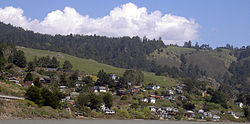
Jenner, also known as Jenner-by-the-Sea, is a small coastal town and census-designated place (CDP) in Sonoma County, California, United States, with a population of 122 per the 2020 Census. [3] It is located on the Pacific coast near the mouth of the Russian River. State Route 1 runs through the town and State Route 116 runs nearby, along the Russian River. Immediately south of Jenner is Goat Rock Beach, a unit within the Sonoma Coast State Beach. Directly north, the Jenner Headlands Preserve offers scenic overlooks of the Jenner Estuary and surrounding areas.

Contents

History

Historically, Jenner was part of the Rancho Muniz. The town’s namesake, Dr. Elijah K. Jenner, was a dentist and inventor from Vermont. When his son Charles K. was born in 1846, the family was living in Wisconsin. Elijah came west in 1850 and sought his fortune in the California goldfields. Working as a miner, he designed a pump that could raise water one hundred feet (30 m) high. His patent application included a model pump made of pure gold, which is the only golden model that the Patent Office has ever received. [4]

Jenner’s family joined him in 1852. Traveling by ship from the Great Lakes to Panama, it crossed the Isthmus and sailed up the Pacific Coast. By 1854, the Jenners had settled near the mouth of the Russian River and built a house in what became known as Jenner Gulch, the site of the town. Charles K. Jenner would go on to be a prominent attorney in early Seattle, arguing several cases in front of the U.S. Supreme Court. [5]

Stillwater Cove Regional Park, located 16 miles (26 km) north of Jenner, features picnic facilities, beach access, and a historic one-room schoolhouse. [6]

Jenner received media attention in 2004 after the bodies of Lindsay Cutshall and Jason S. Allen were discovered on Fish Head Beach just north of town. The incident became known as the Jenner, California double-murder of 2004. [7]

Geography

According to the United States Census Bureau, the CDP covers an area of 2.4 square miles (6.2 km2), 2.1 square miles (5.5 km2) of it land, and 0.3 square miles (0.7 km2) of it (12.00%) water.

Demographics

Historical population
CensusPop.Note
2010 136
2020 122−10.3%
U.S. Decennial Census [8]

2010

The 2010 United States Census [9] reported that Jenner had a population of 136. The population density was 56.7 inhabitants per square mile (21.9/km2). The racial makeup of the CDP was 91.9% White, 1.5% African American, 1.5% Asian, and 5.1% from two or more races. 5.9% of the population was Hispanic or Latino of any race.

The Census reported that 100% of the population lived in households.

There were 80 households, out of which 6 (7.5%) had children under the age of 18 living in them, 26 (32.5%) were opposite-sex married couples living together, 6 (7.5%) had a female householder with no husband present, 2 (2.5%) had a male householder with no wife present. There were 6 (7.5%) unmarried opposite-sex partnerships, and 2 (2.5%) same-sex married couples or partnerships. 36 households (45.0%) were made up of individuals, and 9 (11.3%) had someone living alone who was 65 years of age or older. The average household size was 1.70. There were 34 families (42.5% of all households); the average family size was 2.24.

The population was spread out, with 7 people (5.1%) under the age of 18, 3 people (2.2%) aged 18 to 24, 15 people (11.0%) aged 25 to 44, 81 people (59.6%) aged 45 to 64, and 30 people (22.1%) who were 65 years of age or older. The median age was 58.5 years. For every 100 females, there were 106.1 males. For every 100 females age 18 and over, there were 115.0 males.

There were 158 housing units at an average density of 65.9 per square mile (25.4/km2), of which 66.3% were owner-occupied and 33.8% were occupied by renters. The homeowner vacancy rate was 1.9%; the rental vacancy rate was 35.7%. 67.6% of the population lived in owner-occupied housing units and 32.4% lived in rental housing units.

Jenner California Jenner California.jpg
Jenner California

2000

As of Census 2000, figures for Jenner's zip code showed that of the primary languages spoken in Jenner 94% spoke English while 6% did not; of those, 2% spoke French, 2% spoke Spanish, 1% spoke German, 1% spoke Urdu, and less than 1% spoke a Native American language. [10]

Climate

Jenner experiences a cool summer Mediterranean climate (Köppen climate classification Csb) typical of coastal areas of California. The wet season, typified by heavy rainfall, is from October to May. Summers are often overcast, the sun blocked by marine layer clouds that keep it cool, humid, and often drizzly in the night and morning hours.

Climate data for Jenner
MonthJanFebMarAprMayJunJulAugSepOctNovDecYear
Mean daily maximum °F (°C)57
(14)
58
(14)
59
(15)
61
(16)
63
(17)
65
(18)
66
(19)
67
(19)
68
(20)
66
(19)
61
(16)
57
(14)
62
(17)
Mean daily minimum °F (°C)40
(4)
42
(6)
42
(6)
42
(6)
44
(7)
46
(8)
48
(9)
49
(9)
48
(9)
46
(8)
43
(6)
40
(4)
44
(7)
Average precipitation inches (mm)7.21
(183)
6.21
(158)
5.59
(142)
2.41
(61)
1.05
(27)
0.33
(8.4)
0.14
(3.6)
0.26
(6.6)
0.64
(16)
2.22
(56)
5.35
(136)
5.67
(144)
37.08
(942)
Source: [11]

Related Research Articles

<span class="mw-page-title-main">Dillon Beach, California</span> Census-designated place in California, United States

Dillon Beach is a census-designated place (CDP) in Marin County, California, United States. It is located 3.25 miles (5.2 km) west of Tomales, at an elevation of 89 ft (27 m). The population was 246 at the 2020 census. Dillon Beach was named after the founder, George Dillon, who settled there in 1858. The area includes a public access beach, as well as a private beach resort, the only private beach in California.

<span class="mw-page-title-main">Tomales, California</span> Census-designated place in California, United States

Tomales is a census-designated place (CDP) on State Route 1 in Marin County, California, United States. The population was 187 at the 2020 census.

<span class="mw-page-title-main">Bodega Bay, California</span> Census-designated place in California, United States

Bodega Bay is a village and census-designated place (CDP) in Sonoma County, California, United States. The population was 912 at the 2020 census. The town, located along State Route 1, is on the eastern side of Bodega Harbor, an inlet of Bodega Bay on the Pacific coast.

<span class="mw-page-title-main">El Verano, California</span> Census-designated place in California, United States

El Verano is a census-designated place (CDP) in Sonoma Valley, Sonoma County, California, United States. The population was 4,123 at the 2010 census, falling to 3,867 at the 2020 census.

<span class="mw-page-title-main">Eldridge, California</span> Census-designated place in California, United States

Eldridge is a census-designated place (CDP) in Sonoma County, California, United States. The population was 1,233 at the 2010 census. It is notably the home to the Sonoma Developmental Center, the largest facility serving the needs of persons with developmental disabilities in the state.

<span class="mw-page-title-main">Fetters Hot Springs-Agua Caliente, California</span> Census-designated place in California, United States

Fetters Hot Springs-Agua Caliente is a census-designated place (CDP) in Sonoma Valley, Sonoma County, California, in the United States. As of the 2010 census, the CDP population was 4,144. The name Agua Caliente translates into English, from Spanish, as hot water, referring to the hot springs historically found in the area.

<span class="mw-page-title-main">Forestville, California</span> Census-designated place in California, United States

Forestville is a census-designated place (CDP) in Sonoma County, California, United States. It was settled during the late 1860s and was originally spelled Forrestville after one of its founders. The spelling long ago became standardized with one "r". The population was 3,293 at the 2010 census, an increase of nearly 1,000 since the 2000 census.

<span class="mw-page-title-main">Glen Ellen, California</span> Census designated place in California, United States

Glen Ellen is a census-designated place (CDP) in Sonoma Valley, Sonoma County, California, United States. The population was 784 at the 2010 census, down from 992 at the 2000 census. Glen Ellen is the location of Jack London State Historic Park, Sonoma Valley Regional Park, and a former home of Hunter S. Thompson.

<span class="mw-page-title-main">Graton, California</span> Census-designated place in California, United States

Graton is an unincorporated town and census-designated place (CDP) in west Sonoma County, California, United States. The population was 1,707 at the 2010 census. Graton's ZIP code is 95444. The town also has a culinary reputation attributed to two restaurants in the area.

<span class="mw-page-title-main">Guerneville, California</span> Census-designated place in California, United States

Guerneville is an unincorporated community and census-designated place in the Russian River Valley of Sonoma County, California, United States. The town is historically known for the logging community, formed in the late 1800s. Guerneville is also known for its natural environment, liberal atmosphere, and proximity to wine-tasting and redwood forests. It was founded by the Guerne family in the 1850s.

<span class="mw-page-title-main">Monte Rio, California</span> Census-designated place in California, United States

Monte Rio is a census-designated place (CDP) in Sonoma County, California along the Russian River near the Pacific Ocean. The town of Guerneville lies northeast of Monte Rio, and Jenner is to the west. The population was 1,152 at the 2010 census, up from 1,104 at the 2000 census. Bohemian Grove is located in Monte Rio.

<span class="mw-page-title-main">Temelec, California</span> Census-designated place in California, United States

Temelec is a census-designated place (CDP) in Sonoma County, California, United States. The population was 1,441 at the 2010 census.

<span class="mw-page-title-main">Larkfield-Wikiup, California</span> Census-designated place in California, United States

Larkfield-Wikiup is a census-designated place unincorporated area in Sonoma County, California, United States. The population was 8,884 at the 2010 census, up from 7,479 at the 2000 census. It comprises the Mark West area between Santa Rosa, Windsor (north), Calistoga (east), and Fulton (west). There are at least four schools within the limits of the CDP, including Cardinal Newman High School, John B. Riebli Elementary School, Mark West Elementary, and San Miguel Elementary schools.

<span class="mw-page-title-main">Cazadero, California</span> Unincorporated community in California, United States

Cazadero is an unincorporated community and census-designated place (CDP) in western Sonoma County, California, United States with a population of 354 in 2010. The downtown of Cazadero consists of two churches, a general store, a post office, a hardware store, an auto repair garage, private office space, and the Cazadero Volunteer Fire Department.

Valley Ford is an unincorporated community and census-designated place (CDP) in western Sonoma County, California, United States. It is located on State Route 1 north of San Francisco. Like all of Sonoma County, Valley Ford is included in both the San Francisco Bay Area and the Redwood Empire.

<span class="mw-page-title-main">Geyserville, California</span> Place in California, United States

Geyserville is an unincorporated community and census-designated place (CDP) in Sonoma County, California, USA. Located in the Wine Country, Geyserville has a small selection of restaurants, bed and breakfasts, and wineries. Geyserville is located on California State Route 128, close to US Route 101. The population was 862 at the 2010 census.

Salmon Creek is an unincorporated community settlement and census-designated place (CDP) in Sonoma County, California, U.S. It is located on the Pacific coast about 90 minutes drive north of San Francisco, between the towns of Jenner and Bodega Bay, California. The population was 86 at the 2010 census.

<span class="mw-page-title-main">Bloomfield, California</span> Census-designated place in California, United States

Bloomfield is a census-designated place in Sonoma County, California, U.S. It is located in a rural area about 11 miles (18 km) southwest of Santa Rosa at the junction of Bloomfield Road and Valley Ford Road. Americano Creek flows westward along the south edge of the town.

<span class="mw-page-title-main">Fulton, California</span> Census-designated place in California, United States

Fulton is a census-designated place (CDP) in Sonoma County, California, United States. Fulton is just to the north of the city limits of Santa Rosa, and 7 miles (11 km) north-northeast of Sebastopol. Fulton has a post office, established in 1871 and assigned ZIP code 95439. The community is named after Thomas and James Fulton, who founded the community. The population as of the 2010 U.S. Census was 541. There are a set of railway lines which go through the town boundaries; these lines are used by Sonoma–Marin Area Rail Transit. Fulton was once home to a chicken processing plant that was in operation from the 1960s until its closure in 2010.

<span class="mw-page-title-main">Timber Cove, California</span> Census-designated place in California, United States

Timber Cove is a census-designated place (CDP) in Sonoma County, California. Timber Cove sits at an elevation of 554 feet (169 m). The 2010 United States census reported Timber Cove's population was 164.

References

  1. U.S. Census Archived 2012-07-02 at the Wayback Machine
  2. U.S. Geological Survey Geographic Names Information System: Jenner
  3. "Census 2020: Jenner CDP, California". United States Census Bureau . Retrieved December 22, 2021.
  4. Dawson, Arthur (November 2, 2015). "How Jenner Got Its Name". The Press Democrat. Retrieved March 23, 2021.
  5. Dawson, Arthur (November 2, 2015). "How Jenner Got Its Name". The Press Democrat. Retrieved March 23, 2021.
  6. "Stillwater Cove Regional Park" . Retrieved January 15, 2008.
  7. Doyle, Jim (May 3, 2006). "Tantalizing clues in pair's slaying". The San Francisco Chronicle. Retrieved December 5, 2007.
  8. "Census of Population and Housing". Census.gov. Retrieved June 4, 2016.
  9. "2010 Census Interactive Population Search: CA - Jenner CDP". U.S. Census Bureau. Archived from the original on July 15, 2014. Retrieved July 12, 2014.
  10. MLA Date Center Archived 2008-08-01 at the Wayback Machine , access date July 31, 2008
  11. "Jenner historic weather averages". Intellicast. Retrieved February 12, 2010.