The San Francisco Peninsula is a peninsula in the San Francisco Bay Area that separates San Francisco Bay from the Pacific Ocean. On its northern tip is the City and County of San Francisco. Its southern base is Mountain View, south of Palo Alto and north of Sunnyvale and Los Altos. Most of the Peninsula is occupied by San Mateo County, between San Francisco and Santa Clara counties, and including the cities and towns of Atherton, Belmont, Brisbane, Burlingame, Colma, Daly City, East Palo Alto, El Granada, Foster City, Hillsborough, Half Moon Bay, La Honda, Loma Mar, Los Altos, Menlo Park, Millbrae, Pacifica, Palo Alto, Pescadero, Portola Valley, Redwood City, San Bruno, San Carlos, San Mateo, South San Francisco, and Woodside.

Palo Alto is a charter city in the northwestern corner of Santa Clara County, California, United States, in the San Francisco Bay Area, named after a coastal redwood tree known as El Palo Alto.

San Mateo County, officially the County of San Mateo, is a county located in the U.S. state of California. As of the 2020 census, the population was 764,442. Redwood City is the county seat, and the third most populated city following Daly City and San Mateo. San Mateo County is included in the San Francisco–Oakland–Berkeley, CA MSA, Silicon Valley, and is part of the San Francisco Bay Area, the nine counties bordering San Francisco Bay. It covers most of the San Francisco Peninsula. San Francisco International Airport is located in the northeastern area of the county and is approximately 7 miles south of the city and county limits of San Francisco, even though the airport itself is assigned a San Francisco postal address. The county's built-up areas are mostly suburban, and are home to several corporate campuses.

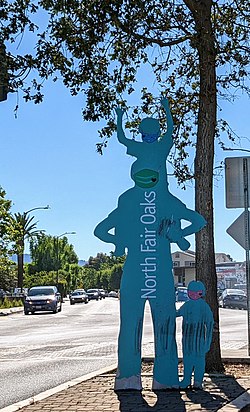
Menlo Park is a city at the eastern edge of San Mateo County within the San Francisco Bay Area of California in the United States. It is bordered by San Francisco Bay on the north and east; East Palo Alto, Palo Alto, and Stanford to the south; and Atherton, North Fair Oaks, and Redwood City to the west. It had 33,780 residents at the 2020 United States census. It is home to the corporate headquarters of Meta, and is where Google, Roblox Corporation and Round Table Pizza were founded. The train station holds the record as the oldest continually operating train station in California. It is one of the most educated cities in California and the United States; nearly 70% of residents over 25 have earned a bachelor's degree or higher.

Atherton is an incorporated town in San Mateo County, California, United States. Its population was 7,188 as of 2020.
Belmont is a city in San Mateo County in the U.S. state of California. It is in the San Francisco Bay Area, on the San Francisco Peninsula about halfway between San Francisco and San Jose. Known for its wooded hills, views of the San Francisco Bay and stretches of open space, Belmont is a quiet residential community in the midst of the culturally and technologically rich Bay Area. It was originally part of Rancho de las Pulgas, for which one of its main roads, the Alameda de las Pulgas, is named. The city was incorporated in 1926. Its population was 28,335 at the 2020 census.

East Palo Alto is a city in San Mateo County, California, United States. As of the 2020 census, the population of East Palo Alto was 30,034. It is situated on the San Francisco Peninsula, roughly halfway between the cities of San Francisco and San Jose. To the north and east is the San Francisco Bay, to the west is the city of Menlo Park, and to the south the city of Palo Alto. Despite being called "East" Palo Alto, the city is directly north of Palo Alto. While often incorrectly assumed to be part of the city of Palo Alto, East Palo Alto has always been a separate entity since its founding as an unincorporated community and its incorporation in July 1983. It is also in San Mateo County, while Palo Alto is in Santa Clara County. The two cities are separated only by San Francisquito Creek and, largely, the Bayshore Freeway. The revitalization projects in 2000, and high income high-tech professionals moving into new developments, including employees from Google and Facebook, have begun to slowly eliminate the historically wide cultural and economic differences between the two cities. East Palo Alto and Palo Alto share both telephone area codes and postal ZIP codes.

Emerald Lake Hills or Emerald Hills is a census-designated place and neighborhood in unincorporated San Mateo County, in the state of California, United States. Situated among oak-studded hills between Woodside, Redwood City, and San Carlos roughly bounded by Edgewood Road, Alameda de las Pulgas, Farm Hill Boulevard, and Interstate 280. The population was 4,406 at the 2020 census and the per-capita income was $68,966, making it the 22nd wealthiest place in California and the 82nd highest income places in the United States

Hillsborough is an incorporated town in San Mateo County, California, in the San Francisco Bay Area. It is located 17 miles (27 km) south of San Francisco on the San Francisco Peninsula, bordered by Burlingame to the north, San Mateo to the east, Highlands-Baywood Park to the south, and Interstate 280 to the west. The population was 11,387 at the 2020 census.
Portola Valley is a town in San Mateo County, California. Located on the San Francisco Peninsula in the Bay Area, Portola Valley is a small, wealthy community nestled on the eastern slopes of the Santa Cruz Mountains.

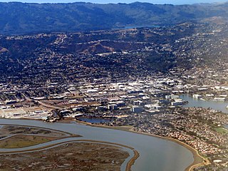
Redwood City is a city on the San Francisco Peninsula in Northern California's Bay Area, approximately 27 miles (43 km) south of San Francisco, and 24 miles (39 km) northwest of San Jose. Redwood City's history spans its earliest inhabitation by the Ohlone people to being a port for lumber and other goods. The county seat of San Mateo County in the heart of Silicon Valley, Redwood City is home to several global technology companies including Oracle, Electronic Arts, Evernote, Box, and Informatica. The city's population was 84,292 according to the 2020 census. The Port of Redwood City is the only deepwater port on San Francisco Bay south of San Francisco.

San Carlos is a city in San Mateo County, California, United States. The population is 30,722 per the 2020 census.

West Menlo Park is a census-designated place and an Unincorporated community in San Mateo County, California, located between the majority of City of Menlo Park, the Town of Atherton, the Sharon Heights neighborhood of Menlo Park and Stanford University. As of the 2020 census, the community had a population of 3,930.

Woodside is a small incorporated town in San Mateo County, California, United States, on the San Francisco Peninsula. It has a council–manager system of government. The population of the town was 5,309 at the 2020 census.

Hetch Hetchy is a valley, a reservoir, and a water system in California in the United States. The glacial Hetch Hetchy Valley lies in the northwestern part of Yosemite National Park and is drained by the Tuolumne River. For thousands of years before the arrival of settlers from the United States in the 1850s, the valley was inhabited by Native Americans who practiced subsistence hunting-gathering. During the late 19th century, the valley was renowned for its natural beauty – often compared to that of Yosemite Valley – but also targeted for the development of water supply for irrigation and municipal interests. The controversy over damming Hetch Hetchy became mired in the political issues of the day. The law authorizing the dam passed Congress on December 7, 1913.
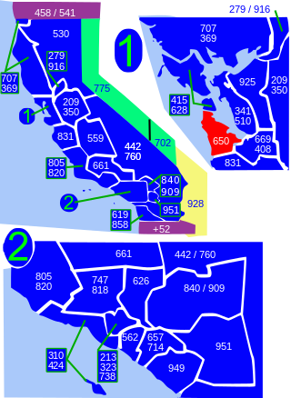
Area code 650 is a telephone area code in the North American Numbering Plan (NANP) for the San Francisco Bay Area in the U.S. state of California. It was split from area code 415 on August 2, 1997, and includes most of San Mateo County, part of San Francisco, and the northwestern portion of Santa Clara County including Palo Alto, Mountain View, and Los Altos.
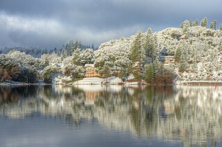
Pine Mountain Lake (PML) is a private gated community and a census-designated place (CDP) in Tuolumne County, California. It is located 0.8 miles (1.3 km) north and east of Groveland. Pine Mountain Lake sits at an elevation of 2,795 feet (852 m). The 2010 United States census reported Pine Mountain Lake's population was 2,796.
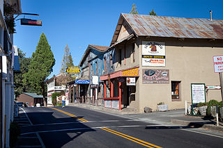
Groveland is a census-designated place (CDP) in Tuolumne County, California. Groveland sits at an elevation of 3,136 feet (956 m). The 2020 United States census reported Groveland's population was 540.
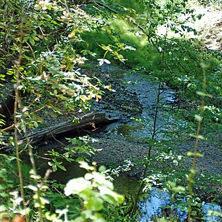
Bear Creek, or Bear Gulch Creek, is a 6.6-mile-long (10.6 km) southeastward-flowing stream originating north of the summit of Sierra Morena in the Santa Cruz Mountains, near the community of Kings Mountain in San Mateo County, California, United States. It flows through the town of Woodside. Bear Creek and Corte Madera Creek join to become San Francisquito Creek in the Jasper Ridge Biological Preserve at Stanford University.

The Peninsula Library System (PLS) is a consortium of public and community college libraries in San Mateo County, California, United States, which serves the part of the San Francisco Bay Area known as "The Peninsula". The system has dozens of branches in local communities and at various area community colleges, a bookmobile, and automated book kiosks called Library-a-Go-Go.