Brentwood, California

Last updated

City of Brentwood
Downtown Brentwood California.jpg
Gateway to downtown Brentwood
Flag of Brentwood, California.gif
Brentwood California Logo.svg
Contra Costa County California Incorporated and Unincorporated areas Brentwood Highlighted 0608142.svg
Location of Brentwood in Contra Costa County, California.
Usa edcp relief location map.png
Red pog.svg
City of Brentwood
Location in the United States
Coordinates: 37°55′55″N121°41′45″W / 37.93194°N 121.69583°W / 37.93194; -121.69583
Country United States
State California
County Contra Costa
Incorporated January 21, 1948 [1]
Named for Brentwood, Essex, England
Government
   Mayor Joel Bryant [2]
   State Senator Steve Glazer (D) [3]
   State Assembly Tim Grayson (D) [4]
   U. S. Congress Josh Harder (D) [5]
Area
[6]
  Total14.87 sq mi (38.50 km2)
  Land14.87 sq mi (38.50 km2)
  Water0.00 sq mi (0.00 km2)  0.13%
Elevation
79 ft (24 m)
Population
 (2020)
  Total64,292
  Density4,325.06/sq mi (1,669.87/km2)
Time zone UTC-8 (PST)
  Summer (DST) UTC-7 (PDT)
ZIP code
94513
Area code 925
FIPS code 06-08142
GNIS feature IDs 277479, 2409902
Website brentwoodca.gov

Brentwood is a city in Contra Costa County, California, United States. It is located in the East Bay region of the San Francisco Bay Area. The population is 66,854 as of 2022, an increase of 287% from 23,302 at the 2000 census. [7]

Contents

Brentwood was settled by Euro-Americans in the late 19th century. The community is still known throughout the Bay Area for its agricultural products - primarily its cherries, corn and peaches. Due to urban sprawl many of the old farms and orchards have been replaced by suburban developments since 1990. Brentwood is increasingly residential, with the rate of population growth in the triple digits during the 1990s and 69% from 2000 through 2010. An official estimate showed the population increased nearly 21% during the period 2010 to 2016.

History

Don Jose Noriega, a wealthy Californio ranchero, was granted Rancho Los Meganos in 1835, covering all of modern Brentwood. Jose Noriega (Mayor of San Jose).jpg
Don José Noriega, a wealthy Californio ranchero, was granted Rancho Los Méganos in 1835, covering all of modern Brentwood.

Brentwood was originally laid out on land donated from property owned by John Marsh, an East Contra Costa County pioneer who acquired Rancho Los Méganos, the land grant that Brentwood is built upon, in 1837 from Jose Noriega. Marsh was one of the wealthiest men in California and was instrumental in its becoming independent from Mexico and part of the United States. His letters extolling the potential for agriculture in California were published in newspapers throughout the East. They resulted in the first wagon trains to California. Marsh encouraged this, and allowed new arrivals to stay on his ranch until they could get settled. Rancho Los Méganos became the terminus of the California Trail. [8] Brentwood was named after Marsh's ancestral home, the town of Brentwood in the County of Essex, England. [9]

Brentwood's first post office was established in 1878. [10] The city incorporated in 1948. [10]

Balfour, Guthrie & Co., a British investment company, purchased the John Marsh ranch in 1910. The company invested heavily in other California agricultural properties as well. In 1910, it built the Brentwood Hotel at Oak Street and Brentwood Boulevard, across from the railroad station. This replaced an earlier hotel on the same site that had burned down in 1903. The hotel was razed in 1967, and replaced by a service station. [11]

Original Brentwood water tower BrentwoodWaterTower.jpg
Original Brentwood water tower

The Brentwood water tower perhaps symbolizes the city's transition from a rural farm community to a modern bedroom community. This landmark on Walnut Boulevard, across the street from the Brentwood Park and Ride lot, is the tallest structure in the city. It is no longer used for its original purpose, but now serves as a cell phone tower. City water is stored in large tanks atop hills outside the city.

The city is bordered on three sides by the Contra Costa County Agricultural Core which consists of 11,000 acres of preserved and still actively productive farm land.

During the 1990s, many retail stores were built along the Brentwood/Antioch border on Lone Tree Way, on both sides of SR 4, about 3.5 miles (5.6 km) from downtown Brentwood. The Streets of Brentwood, an outdoor lifestyle retail center, along Sand Creek Rd opened in 2008.

The city broke ground for a new civic center in November 2009. The Mission-style architectural inspiration for City Hall, the main building, was the 1910 Brentwood Hotel. The $60 million project, completed in May 2012, includes the 58,000-square-foot City Hall and state-of-the-art City Council Chambers, a 32,000-square-foot community center, 280-space parking garage and redevelopment of the 12-acre City Park. The community center also includes arts and crafts rooms as well as studios for dance classes and community exercise programs. The center received a Leadership in Energy and Environmental Design silver certification for amenities such as green roofs, biosales, permeable paving and infiltration planters. [12] City departments began moving into the new facility in October 2011, and the former city hall was demolished during November 2011.

Indigenous history

Brentwood was home to the Julpuns who settled mainly in the upper corner of the East Bay. The Julpun were Native Americans who were a part of the Bay Miwok tribes who spoke the same language in an area, which is a branch of the Eastern Miwok Language. The Bay Miwok tribes would generally include 50-200 people in each village, where they would build their villages along the creeks since they were filled with fish. The Julpun believed that everything in the world had a life or spirit and were very in tune with the nature around them. They set things as sacred where they would pray at as part of their religious beliefs, they ended up coining Mt. Diablo, or as they call it Supremenenu, as the birthplace of the world. Due to this, they would hold the top points of Mt. Diablo to be used for sacred gatherings or religious purposes. [13]

Back then the Julpun were never reached out to by ethnographers or linguists when the Julpun still retained their language, the Bay Miwok. They weren't mainly concentrated but spread out from the San Joaquin River to the bottom part of Marsh Creek which is now the southern part of Brentwood. Between 1806 and 1808 few of the Julpun migrated over to Mission San Jose with about 100 or so went by 1813. Later on Milliken listed down that about 141 Julpun members were baptized by 1819 from Mission San Jose. As time went on, Mission San Jose converted from religious beliefs and values to secular institutions where the Julpun members ended up leaving in 1836 back to their original territory. John Marsh ended up acquiring Rancho Los Meganos from Jose Noriega in 1837 which would cover modern Brentwood and back then cover the Julpuns territory. However, due to Mission San Jose revoking the spiritual possession it once had, the Julpuns may have gone back to their territory and ended up working under John Marsh on the land where their home once was. [14]

In present time the Julpun tribe have more or less settled around the Bay Area. Some are living in specific groups, while others are living in society where they are preserving their native culture even though they may be away from their tribes. They (the Julpun) are working with the National Park Service, where they united under one federally recognized tribe called the Federated Indians of Graton Rancheria. [15]

Geography

Photo of Mount Diablo, showing Brentwood behind the mountain and to the right. Northpeak.jpg
Photo of Mount Diablo, showing Brentwood behind the mountain and to the right.

As is common with many East Bay towns in Contra Costa County, Mount Diablo is clearly seen from Brentwood. Brentwood is located on the alluvial plain of the Sacramento-San Joaquin Delta. In the picture shown at right, Brentwood lies center right and the city of Antioch, California lies center left. North Peak appears in the foreground between the two cities and largely hides the city of Oakley.

The East Bay Regional Park District is a special San Francisco Bay Area district operating in the East Bay counties of Alameda County and Contra Costa County. East Bay Regional Park District trails and parks are found in Brentwood.

Brentwood has a total area of 14.81 sq mi (38.4 km2), of which 14.79 sq mi (38.3 km2) is land and 0.02 sq mi (0.05 km2) or 0.13% is water. The landscape on the west is marked by rolling hills, non-native grasses, oak trees, fruit orchards, and vineyards, with a number of public golf courses.

Climate

Brentwood borders on the Mediterranean (Csa) and Semi-arid climates (Bsh). Like most of East Contra Costa County, Brentwood lies in the rain shadow of Mt. Diablo and receives less rainfall than many of its neighbors. [16] The wet season is generally October through April, though there may be a day or two of light rainfall in June or September. Summer heat is often moderated by the Delta breeze, especially in the late afternoon, causing temperatures to cool rapidly. [17]

Climate data for Brentwood, California
MonthJanFebMarAprMayJunJulAugSepOctNovDecYear
Record high °F (°C)77
(25)
80
(27)
90
(32)
96
(36)
103
(39)
117
(47)
114
(46)
110
(43)
115
(46)
103
(39)
88
(31)
75
(24)
117
(47)
Mean daily maximum °F (°C)54
(12)
60
(16)
66
(19)
71
(22)
79
(26)
86
(30)
92
(33)
90
(32)
86
(30)
77
(25)
64
(18)
55
(13)
73
(23)
Mean daily minimum °F (°C)39
(4)
43
(6)
45
(7)
48
(9)
54
(12)
58
(14)
59
(15)
59
(15)
57
(14)
52
(11)
45
(7)
39
(4)
50
(10)
Record low °F (°C)20
(−7)
22
(−6)
27
(−3)
28
(−2)
37
(3)
38
(3)
43
(6)
45
(7)
42
(6)
28
(−2)
24
(−4)
18
(−8)
18
(−8)
Average precipitation inches (mm)2.66
(68)
2.43
(62)
2.08
(53)
.78
(20)
.43
(11)
.09
(2.3)
0
(0)
.02
(0.51)
.18
(4.6)
.62
(16)
1.60
(41)
2.41
(61)
13.3
(339.41)
Source: [18]

Government

The City of Brentwood operates under the City Manager form of government. Under policy direction of the City Council, the City Manager serves as the Chief Administrative Officer of the city; assumes full responsibility for planning, administering, directing, overseeing, and evaluating the activities and operations of all City departments. The following city departments report directly to the manager:

Politics

According to the California Secretary of State, as of February 10, 2019, Brentwood has 34,774 registered voters. Of those, 13,974 (40.2%) are registered Democrats, 9,710 (27.9%) are registered Republicans, and 9,376 (27%) have declined to state a political party. [20]

Brentwood Police Department (BPD)

Brentwood established its own city police department in 1948, when it was primarily a small farming community. It now serves an area of 14 square miles (36 km2), divided into 4 geographic areas. [21]

Thomas Hansen is the current police chief, appointed in Sept 2022. [22]

Fire Protection

Fire protection is provided by the East Contra Costa Fire Protection District (ECCFPD), which reports to the Contra Costa County Board of Supervisors. Resources are shared with the communities of Oakley, Bethel Island, Knightsen, Byron and Discovery Bay. It also covers certain unincorporated areas of the county. The fire district is headquartered in the Brentwood City Hall building.

The fire district had to close two fire stations in 2015 because of funding issues. This has left only three stations to cover an area of 249 square miles. One station remains open in Brentwood, Oakley, and Discovery Bay. [23]

Delta Patrol Station

The Delta Patrol Station, a unit of the Contra Costa County Sheriff's office has signed an agreement with the City of Brentwood to move its existing office from Oakley to a larger space in Brentwood. The Delta Patrol Station has occupied a 1920s era building for over four decades, and has been looking for a larger facility in East County to serve the growing population for faster response in unincorporated Contra Costa County areas (e.g., Byron, Discovery Bay and Knightsen). Response time for Bethel Island is expected to remain the same. [24]

Education

Public schools

Brentwood's public education system has about 7 elementary, 3 middle, bristow middle school, edna middle school, and Adams middle school and 4 high schools, Independence High School, Liberty High School, La Paloma High School, and Heritage High School.

The city is served by the Brentwood Union School District, Knightsen School District and the Liberty Union High School District. The Brentwood Union School District runs on a modified traditional school calendar. The Brentwood Union School District has many schools designated as a California Distinguished School. Approximately five percent of California schools are awarded this honor.

Heritage High School includes a full range of Advanced Placement courses and the highest Academic Performance Index (California public schools)(API) score in the area, stellar performing arts programs, and championship athletic teams. Heritage is also a solar school. The 2.38 kW photovoltaic project installed at Heritage High School is designed to demonstrate the benefits and opportunities created by renewable energy technology and provide a powerful learning tool for both students and the community.

Community college

Los Medanos College began operating a satellite facility (Brentwood Center) at Sand Creek Road and Brentwood Boulevard in the city. The existing Center has outgrown its limited space in a former grocery store, where it has no room for expansion. [25] The Brentwood Center acquired property in the southwest part of the city, where it plans built a new 18 acres (7.3 ha) campus that opened in 2021. [26] [27]

Public library

The temporary Brentwood branch of the Contra Costa County Library, located at 104 Oak Street, across from the Civic Center and City Park, was razed early in 2017, along with two other city-owned buildings at 118 and 120 Oak Street to be replaced by the long-awaited new Brentwood branch library. The Brentwood City Council approved the design for the new 20,000 square feet (1,900 m2) facility in September 2016. [28] The facility was completed in 2018, and serves a population of more than 50,000. The library collection includes materials in both Spanish and English. It also offers a wide variety of media, including DVDs, CDs, and audiobooks, as well as a large print collection. The library offers a number of programs for all ages, including storytimes for babies and toddlers. [29]

Demographics

Historical population
CensusPop.Note
1950 1,729
1960 2,18626.4%
1970 2,64921.2%
1980 4,43467.4%
1990 7,56370.6%
2000 23,302208.1%
2010 51,481120.9%
2020 64,29224.9%
U.S. Decennial Census [30]

2010

The 2010 United States census [31] reported that Brentwood had a population of 51,481. The population density was 3,477.3 inhabitants per square mile (1,342.6/km2). The racial makeup of Brentwood was 34,969 (67.9%) White, 3,389 (6.6%) African American, 333 (0.6%) Native American, 4,051 (7.9%) Asian, 202 (0.4%) Pacific Islander, 4,964 (9.6%) from other races, and 3,573 (6.9%) from two or more races. Hispanic or Latino of any race were 13,779 persons (26.8%).

The census reported that 51,335 people (99.7% of the population) lived in households, 141 (0.3%) lived in non-institutionalized group quarters, and 5 (0%) were institutionalized.

There were 16,494 households, out of which 8,047 (48.8%) had children under the age of 18 living in them, 10,560 (64.0%) were opposite-sex married couples living together, 1,823 (11.1%) had a female householder with no husband present, 825 (5.0%) had a male householder with no wife present. There were 794 (4.8%) unmarried opposite-sex partnerships, and 141 (0.9%) same-sex married couples or partnerships. 2,616 households (15.9%) were made up of individuals, and 1,355 (8.2%) had someone living alone who was 65 years of age or older. The average household size was 3.11. There were 13,208 families (80.1% of all households); the average family size was 3.47. The median income for a household in the town was $97,202.

The population was spread out, with 16,058 people (31.2%) under the age of 18, 3,854 people (7.5%) aged 18 to 24, 13,991 people (27.2%) aged 25 to 44, 11,703 people (22.7%) aged 45 to 64, and 5,875 people (11.4%) who were 65 years of age or older. The median age was 35.6 years. For every 100 females, there were 94.2 males. For every 100 females age 18 and over, there were 90.4 males.

There were 17,523 housing units at an average density of 1,183.6 per square mile (457.0/km2), of which 16,494 were occupied, of which 12,580 (76.3%) were owner-occupied, and 3,914 (23.7%) were occupied by renters. The homeowner vacancy rate was 2.7%; the rental vacancy rate was 6.0%. 38,410 people (74.6% of the population) lived in owner-occupied housing units and 12,925 people (25.1%) lived in rental housing units.

Demographic profile [32] 2010
Total Population51,481 - 100.0%
One Race47,908 - 93.1%
Not Hispanic or Latino37,702 - 73.2%
White alone27,944 - 54.3%
Black or African American alone3,197 - 6.2%
American Indian and Alaska Native alone178 - 0.3%
Asian alone3,903 - 7.6%
Native Hawaiian and Other Pacific Islander alone170 - 0.3%
Some other race alone129 - 0.3%
Two or more races alone2,181 - 4.2%
Hispanic or Latino (of any race)13,779 - 26.8%

2000

As of the 2000 census, there were 23,265 residents. [33] The population density was 2,001.2/sqmi (774/km2). There were 7,788 housing units at an average density of 668.8/sqmi (259/km2). The racial makeup of the town was 75.38% White, 9.40% African American, 0.75% Native American, 6.99% Asian, 0.10% Pacific Islander, 5.96% from other races, and 1.43% from two or more races. Hispanic or Latino of any race were 10.34% of the population. There were 23,700 households, out of which 45.8% had children under the age of 18 living with them, 69.2% were married couples living together, 7.0% had a female householder with no husband present, and 25.4% were non-families. 19.9% of all households were made up of individuals, and 13.3% had someone living alone who was 65 years of age or older. The average household size was 2.58 and the average family size was 2.93. In the town the population was spread out, with 22.9% under the age of 18, 3.2% from 18 to 24, 19.4% from 25 to 44, 33.4% from 45 to 64, and 21.0% who were 65 years of age or older. The median age was 48 years. For every 100 females, there were 96.8 males. For every 100 females age 18 and over, there were 91.7 males. The median income for a household in the town was $87,068, and the median income for a family was $91,796. [34] Males had a median income of $58,059 versus $39,585 for females. The per capita income for the town was $33,621. About 5.4% of families and 9.3% of the population were below the poverty line, including 6.3% of those under age 18 and 3.5% of those age 65 or over.

Economy

Agriculture remains important to the local economy, but has declined in relative importance as the city has become more suburban. Local wineries including Bloomfield, Tamayo, and Hannah Nicole have gained in sales and prestige after winning numerous medals in recent years at the San Francisco Chronicle Wine Competition and the California State Fair. There is no heavy industry and only a small light industrial area in the northeastern part of the city. Brentwood underwent a strong economic boom from 2000 through 2008. Population expanded from 23,302 in 2000 to about 48,000 in 2006, a higher growth rate than other communities in the Bay Area. Some of the new neighborhoods were centered around two new golf courses, the Shadow Lakes Golf Club and the Deer Valley Golf Club, that were constructed to take advantage of the views of Mt. Diablo. The boom stalled in 2009, paralleling the economic crisis that affected all of California, but successful new home subdivisions, including a gated community (Carmel Estates), appeared again in 2010. Within an active adult community (Trilogy at the Vineyards), Club Los Meganos opened in 2010 with 34,000 square feet (3,200 m2) of athletic club, pool and cabanas, gourmet studio, spa, tennis courts, and events center. In 2013, Brentwood's economy displayed renewed economic vigor with substantial new activity in residential and commercial/retail construction. Sales offices of new home subdivisions commonly advertise new houses beginning in the $500Ks with the largest homes with many upgrades nearing $1M. The overall improvement in the Bay Area economy and anticipation for the 2015 completion of eBart and highway improvements in East Contra Costa County are playing a part in the revival of strong economic growth in Brentwood. One of the most exciting development opportunities in Brentwood is linked to the two Federal research facilities – Lawrence Livermore National Laboratory and Sandia National Laboratories – that are located 25 minutes south of Brentwood. Brentwood has established close relations with the national labs and is a member of i-GATE, which is a regional partnership designed to promote tech-oriented business growth connected with the labs.

Top employers

According to the city's 2018 Comprehensive Annual Financial Report, [35] the top employers in the city are:

#Employer# of Employees % of Total City Employment
1Brentwood Union School District6974.63%
2City of Brentwood4482.97%
3Liberty Union High School District4312.86%
4 The Home Depot 1501.00%
5 Safeway 1410.94%
6 John Muir 1320.88%
7Precision Cabinets1300.86%
8Ellison Framing Inc.1250.83%
9 Kohl's 1230.82%
10 WinCo Foods 1020.68%
11 Raley's 1010.67%
12 BJ's Brewhouse 1000.66%
13 Walgreen Co. 850.56%
14Town & Country Roofing750.50%
15Delta Valley Athletic Club140.09%
16 Best Buy 80.05%

Transportation

Highway

Public transportation is very limited, so the principal roads leading into the city are very congested with commuter traffic. No freeways served Brentwood directly until February 2008, when the John Marsh Heritage Highway (also known as the California State Route 4 Bypass or Bypass Road, now California State Route 4) was built to connect the western side of Brentwood directly with Antioch. State Route 4 passes by the western edge of Brentwood. The freeway portion of SR 4 ends just south of the Balfour Road exit. SR 4 continues as a two-lane highway to its intersection with Marsh Creek Road and the end of Vasco Road, an unnumbered highway that is the principal route to Livermore, Interstate 580, and the Silicon Valley. To the southeast of Brentwood, County Route J4, known as the Byron Highway, connects to Tracy and the San Joaquin Valley.

Bus service

Local bus service is provided by Tri Delta Transit, a special purpose district providing public transportation for Eastern Contra Costa County.

Tri Delta Transit Route 300X operates roughly 30-minute express bus service between Brentwood Park & Ride and Antioch BART station Monday through Friday, several times per day. [36]

Tri Delta Transit Route 391 provides weekday and weekend local service between Brentwood Park & Ride and Pittsburgh Center Station, with stops at Antioch BART and Los Medanos College. [37]

The Brentwood Park & Ride is a terminal for Tri Delta Transit routes 202X, 300X, 384, 385, and 391. Tri Delta Transit routes 380, 383, and 395 also serve parts of Brentwood. [38]

Rail

A light rail Bay Area Rapid Transit expansion from Bay Point to Hillcrest Avenue, serving East Contra Costa County, known as eBart, was put into regular service in August 2018.

There is no passenger rail service to Brentwood. The nearest Altamont Corridor Express train station is in Livermore. The nearest Amtrak station is in Antioch.

There is a freight-only rail line that passes through Brentwood, which is owned by Union Pacific Railroad. However, the line has been inactive since the early 1990s. Union Pacific Railroad does have plans to reactivate this line sometime in the future.

Airport

Commercial airports serving this area are:

Other nearby airports serving private aircraft are:

Attractions and lifestyle

Brentwood was one of 212 cities designated by KaBOOM! as a Playful City USA for 2010 - one of only 23 such cities in California and only three in Northern California. [39] This is the seventh consecutive year that Brentwood has been listed. Each community selected demonstrated creative commitments to the cause of play and fitness. Brentwood was selected for a variety of reasons, including the fact that it offers the community its Wellness Policy, a community-wide aspirational goal which promotes physical activity and education as the benefits of living a healthy lifestyle. Brentwood has many parks and miles of jogging trails, to support healthy lifestyles. [40]

The visual and performing arts are well represented in Brentwood. The city is home to the Brentwood Art Society, which sponsors events such as the annual Art, Wine, and Jazz Festival, the Artists Open Studio Tour, open mic nights, and other gatherings and shows. The Art Society is also a supporter of the Brentwood Theater Company, which since 2010 has been producing Broadway musicals and musical reviews in venues around the city. In spring 2014, a major art gallery was opened in the Streets of Brentwood shopping center. [41]

The Brentwood Parks and Recreation Department reports that it is responsible for 72 city parks. Only four of these exceed 10 acres in size, while 23 parks cover less than one acre each. [42]

Points of interest

Related Research Articles

<span class="mw-page-title-main">Contra Costa County, California</span> County in California, United States

Contra Costa County is a county located in the U.S. state of California, in the East Bay of the San Francisco Bay Area. As of the 2020 United States Census, the population was 1,165,927. The county seat is Martinez. It occupies the northern portion of the East Bay region of the San Francisco Bay Area and is primarily suburban. The county's name refers to its position on the other side of the bay from San Francisco. Contra Costa County is included in the San Francisco–Oakland–Berkeley, CA Metropolitan Statistical Area.

<span class="mw-page-title-main">Alamo, California</span> Unincorporated community in California, United States

Alamo is an unincorporated community and census-designated place (CDP) in Contra Costa County, California, in the United States. It is a suburb located in the San Francisco Bay Area's East Bay region, approximately 28 miles (45 km) east of San Francisco. Alamo is equidistant from the city of Walnut Creek and the incorporated town of Danville. As of the 2020 census, the population was 15,314.

<span class="mw-page-title-main">Antioch, California</span> City in California, United States

Antioch is the third-largest city in Contra Costa County, California, United States. The city is located in the East Bay region of the San Francisco Bay Area along the Sacramento–San Joaquin River Delta. The city's population was 115,291 at the 2020 census. The city has grown substantially more diverse since the 1970s.

<span class="mw-page-title-main">Bay Point, California</span> CDP in California, United States

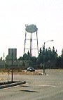
Bay Point, formerly West Pittsburg and originally Bella Vista is a census-designated place located in the East Bay region of the San Francisco Bay Area in Contra Costa County, California. Bay Point is just west of Pittsburg, California, and northeast of Concord, California, on the southern shore of Suisun Bay. The population of Bay Point was 21,349 as of 2010. The Pittsburg/Bay Point Station of the Bay Area Rapid Transit (BART) rail system is located adjacent to Bay Point in Pittsburg. The community is traversed by a freeway, State Route 4, the California Delta Highway. Being unincorporated, Bay Point does not have its own police department. The community is policed by the California Highway Patrol and the Contra Costa County Sheriff's Office. The ZIP code is 94565, and the area code is 925.

<span class="mw-page-title-main">Kensington, California</span> Unincorporated community in California, United States

Kensington is an unincorporated community and census designated place located in the Berkeley Hills, in the East Bay, part of the San Francisco Bay Area, in Contra Costa County, California. In the 20th century it was considered part of Berkeley, although it is across the county line. House numbers follow the pattern used in Berkeley, and Kensington shares two zip codes with the Berkeley Hills area.

<span class="mw-page-title-main">Knightsen, California</span> Census-designated place in California, United States

Knightsen is a census-designated place (CDP) in Contra Costa County, California, in the United States. As of the 2010 census, the CDP population was 1,568, up from 861 reported in the 2000 census.

<span class="mw-page-title-main">Martinez, California</span> City in California, United States

Martinez is a city and the county seat of Contra Costa County, California, United States, in the East Bay region of the San Francisco Bay Area. Located on the southern shore of the Carquinez Strait, the city's population was 37,287 at the 2020 census. The city is named after Californio ranchero Ygnacio Martínez, having been founded on his Rancho El Pinole. Martinez is known for its historic center and its waterfront.

<span class="mw-page-title-main">Oakley, California</span> City in California, United States

Oakley is a city in Contra Costa County, California, United States. It is within the nine-county San Francisco Bay Area. The population at the 2020 United States census was 43,357. Oakley was incorporated in 1999, making it the newest incorporated city in Contra Costa County.

<span class="mw-page-title-main">Pittsburg, California</span> City in California, United States

Pittsburg is a city in Contra Costa County, California, United States. It is an industrial suburb located on the southern shore of the Suisun Bay in the East Bay region of the San Francisco Bay Area, and is part of the Sacramento–San Joaquin River Delta area, the Eastern Contra Costa County area, and the San Francisco Bay Area. The population was 76,416 at the 2020 United States Census.

<span class="mw-page-title-main">Pleasant Hill, California</span> City in California, United States

Pleasant Hill is a city in Contra Costa County, California, United States, in the East Bay of the San Francisco Bay Area. The population was 34,613 at the 2020 census. It was incorporated in 1961. Pleasant Hill is the home of College Park High School, Diablo Valley College, the Pleasant Hill Library of the Contra Costa County Library system, and the Pleasant Hill Recreation & Park District.

<span class="mw-page-title-main">Walnut Creek, California</span> City in California, United States

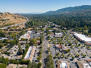
Walnut Creek is a city in Contra Costa County, California, United States, located in the East Bay region of the San Francisco Bay Area, about 16 miles east of the city of Oakland. Walnut Creek has a total population of 70,127 per the 2020 census, is located at the junction of the highways from Sacramento and San Jose (I-680) and San Francisco/Oakland (SR-24), and is accessible by BART. The city shares its borders with Clayton, Lafayette, Alamo, Pleasant Hill, and Concord.

The Bay Miwok are a cultural and linguistic group of Miwok, a Native American people in Northern California who live in Contra Costa County. They joined the Franciscan mission system during the early nineteenth century, suffered a devastating population decline, and lost their language as they intermarried with other native California ethnic groups and learned the Spanish language.

<span class="mw-page-title-main">East Bay</span> Eastern region of the San Francisco Bay Area, California, US

The East Bay is the eastern region of the San Francisco Bay Area and includes cities along the eastern shores of the San Francisco Bay and San Pablo Bay. The region has grown to include inland communities in Alameda and Contra Costa counties. With a population of roughly 2.5 million in 2010, it is the most populous subregion in the Bay Area.

<span class="mw-page-title-main">Tri Delta Transit</span>

Tri Delta Transit, formally the Eastern Contra Costa Transit Authority, is a joint powers agency of the governments of Pittsburg, Antioch, Oakley, Brentwood, and Contra Costa County that provides bus service for the eastern area of Contra Costa County, California, United States. Tri Delta Transit local buses connect to the BART rapid transit system at Antioch, Pittsburg Center, Pittsburg/Bay Point and Concord. Tri Delta Transit buses also connect with County Connection bus service, WestCAT bus service, Delta Breeze bus service and Amtrak at shared bus stops. In 2023, the system had a ridership of 1,304,700, or about 4,800 per weekday as of the fourth quarter of 2023.

<span class="mw-page-title-main">Contra Costa Community College District</span> Community college district in Contra Costa county, California, United States

The Contra Costa Community College District is a community college district that encompasses three community colleges in Contra Costa County, California - Contra Costa College, Diablo Valley College and Los Medanos College. The headquarters is in the George R. Gordon Education Center in Martinez, California.

<span class="mw-page-title-main">Rancho Los Méganos</span>

Rancho Los Méganos was a 13,316-acre (53.89 km2) Mexican land grant in the southwestern Sacramento-San Joaquin Delta region of present-day Contra Costa County, California.

<span class="mw-page-title-main">Marsh Creek (California)</span> River in California, United States

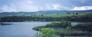
Marsh Creek is a stream in east Contra Costa County, California in Northern California which rises on the eastern side of Mount Diablo and flows 30 miles (48 km) to the Sacramento–San Joaquin River Delta at Oakley, California, near Big Break Regional Shoreline. The creek flows through Marsh Creek State Park (California), where water is impounded to form Marsh Creek Reservoir, then through the city of Brentwood, California.

Vasco Road is a roadway over the Diablo Range that connects Livermore and Brentwood, California. Although it is not part of the California State Highway system, it is the principal north–south commuter route serving eastern Alameda and Contra Costa counties. The two counties are each responsible for maintaining the portion of the road within their boundaries.

<span class="mw-page-title-main">Marsh Creek State Park (California)</span> State park in California, United States

Marsh Creek State Historic Park is a California state park in east Contra Costa County, California, United States. It was named as the newest California State Park on January 27, 2012. The newly named park contains 3,659 acres and is about 3.3 miles (5.3 km) south of downtown Brentwood.

<span class="mw-page-title-main">Stone House of John Marsh</span> United States historic place

The Stone House of John Marsh is a historic stone house in Contra Costa County, California, built in 1855–56. It is now included in the newly designated Marsh Creek State Park. It has not been officially opened to the public because of safety concerns, but restoration began in 2006 and is continuing as of October 2017.

References

  1. "California Cities by Incorporation Date". California Association of Local Agency Formation Commissions. Archived from the original (Word) on November 3, 2014. Retrieved March 27, 2013.
  2. "City Council Members". City of Brentwood. Retrieved December 26, 2020.
  3. "Senators". State of California. Retrieved March 21, 2013.
  4. "Assembly Members". State of California. Retrieved March 21, 2013.
  5. "California's 9th Congressional District - Representatives & District Map". Civic Impulse, LLC. Retrieved March 9, 2013.
  6. "2020 U.S. Gazetteer Files". United States Census Bureau. Retrieved October 30, 2021.
  7. "Brentwood, California Population 2022" . Retrieved December 2, 2022.
  8. Lyman, George D. John Marsh, Pioneer: The Life Story of a Trail-blazer on Six Frontiers, pp. ix, 237-49, The Chautauqua Press, Chautauqua, New York, 1931.
  9. Gudde, Erwin; revised by William Bright (1998). California Place Names (4th ed.). Berkeley, CA: University of California Press. ISBN   978-0-520-21316-6.
  10. 1 2 Durham, David L. (1998). California's Geographic Names: A Gazetteer of Historic and Modern Names of the State. Clovis, Calif.: Word Dancer Press. p. 606. ISBN   1-884995-14-4.
  11. "City of Brentwood Web site, "History and Timeline"". brentwood.ca.us. Archived from the original on September 30, 2013. Retrieved March 19, 2018.
  12. "City of Brentwood Web site". brentwood.ca.us. Archived from the original on July 30, 2013. Retrieved March 19, 2018.
  13. Callaghan, Catherine A. (1996). "Julpun: My Home Town Language".
  14. "The Bay Miwok Language and Land – Museum of the San Ramon Valley" . Retrieved May 19, 2022.
  15. Building 201, Mailing Address: Golden Gate National Recreation Area; Francisco, Fort Mason San; Us, CA 94123-0022 Phone: 415 561-4700 Contact. "Ohlones and Coast Miwoks - Golden Gate National Recreation Area (U.S. National Park Service)". www.nps.gov. Retrieved May 19, 2022.{{cite web}}: CS1 maint: numeric names: authors list (link)
  16. http://www.co.contra-costa.ca.us/depart/cd/water/hcp/archive/downloads/wetland_report/Ch03_Hydrogeomorphic_Setting_10_14_04.pdf [ bare URL PDF ]
  17. Madison, Mike (January 17, 2017). Walking the Flatlands: The Rural Landscape of the Lower Sacramento Valley. Heyday. ISBN   9781890771843 . Retrieved January 17, 2017 via Google Books.
  18. "Monthly Averages for Brentwood, CA (94513)". Weather.com. Retrieved May 17, 2012.
  19. City of Brentwood official website Official City of Brentwood Website
  20. "CA Secretary of State – Report of Registration – February 10, 2019" (PDF). ca.gov. Retrieved March 12, 2019.
  21. "City of Brentwood: Police." Accessed March 9, 2017
  22. https://www.brentwoodca.gov/Home/Components/News/News/125/550?arch=1
  23. Bay Area News Group. "East Contra Costa Fire Protection District closes 2 fire stations." East County Times. May 5, 2015. Accessed March 3, 2017,
  24. Prieve, Judith. "Sheriff's Office Delta Station to be relocated to Brentwood." Brentwood News. December 14, 2018. Accessed December 15, 2018.
  25. Losmedanos.edu: Los Medanos College—Brentwood Center website; accessed August 4, 2010.
  26. Enos, Brenna. "Expanded Los Medanos Brentwood Campus a Go." Los Medanos College. November 4, 2016. Accessed March 11, 2017.
  27. "Brentwood Center - map".
  28. "City of Brentwood, CA - Library Expansion Project".
  29. "About Brentwood Library".
  30. "Census of Population and Housing". Census.gov. Retrieved June 4, 2015.
  31. "2010 Census Interactive Population Search: CA - Brentwood city". U.S. Census Bureau. Archived from the original on February 6, 2016. Retrieved July 12, 2014.
  32. "Demographic Profile Bay Area Census". Archived from the original on December 27, 1996.
  33. "U.S. Census website". United States Census Bureau . Retrieved January 31, 2008.
  34. Bureau, U.S. Census. "American FactFinder - Community Facts". census.gov. Archived from the original on February 10, 2020. Retrieved January 17, 2017.
  35. "City of Brentwood CAFR 2018". brentwoodca.gov. Retrieved April 14, 2019.
  36. "Timetables". Tri Delta Transit. January 14, 2024. Retrieved March 12, 2024.
  37. "Timetables". Tri Delta Transit. January 14, 2024. Retrieved March 12, 2024.
  38. "System Map". Tri Delta Transit. Retrieved March 12, 2024.
  39. "List of 2013 Playful City USA communities". Archived from the original on April 7, 2014. Retrieved February 26, 2014.
  40. Mitchell, Eve, "Brentwood Again a 'Playful City.'" East County Times. May 23, 2014.
  41. King, Paula (February 18, 2014). "New art gallery will bring visual, performing and literary arts together at Streets of Brentwood". Contra Costa Times. Retrieved February 26, 2014.
  42. Welcome! your guide to east county 2017. pp. 57- 58.