Mountain View, Contra Costa County, California

Last updated

Mountain View
Contra Costa County California Incorporated and Unincorporated areas Mountain View Highlighted.svg
Location in Contra Costa County and the state of California
Usa edcp location map.svg
Red pog.svg
Mountain View
Location in the United States
Coordinates: 38°00′32″N122°07′03″W / 38.00889°N 122.11750°W / 38.00889; -122.11750
Country Flag of the United States.svg  United States
State Flag of California.svg  California
County Contra Costa
Government
   State senator Bill Dodd (D) [1]
   Assemblymember Buffy Wicks (D) [2]
   U. S. rep. Tom McClintock (R) [3]
Area
  Total0.3 sq mi (0.8 km2)
  Land0.3 sq mi (0.8 km2)
  Water0 sq mi (0 km2)  0%
Elevation
[4]
112 ft (34 m)
Population
 (2010)
  Total10,234
  Estimate 
(2016) [5]
80,447
  Density34,000/sq mi (13,000/km2)
Time zone UTC-8 (Pacific)
  Summer (DST) UTC-7 (PDT)
ZIP code
94553
Area code 510, 341
FIPS code 06-49651
[4]

Mountain View is a census designated place (CDP) in Contra Costa County, California, United States. The population was 2,372 at the 2010 census.

Contents

Geography

According to the United States Census Bureau, the CDP has a total area of 0.3 square miles (0.75 km2), all of it land.

Demographics

Historical population
CensusPop.Note
2016 (est.)80,447 [5]
U.S. Decennial Census [6]

2010

The 2010 United States Census [7] reported that Mountain View had a population of 2,372. The population density was 8,182.2 inhabitants per square mile (3,159.2/km2). The racial makeup of Mountain View was 1,896 (79.9%) White, 60 (2.5%) African American, 30 (1.3%) Native American, 70 (3.0%) Asian, 20 (0.8%) Pacific Islander, 155 (6.5%) from other races, and 141 (5.9%) from two or more races. Hispanic or Latino of any race were 524 persons (22.1%).

The Census reported that 2,344 people (98.8% of the population) lived in households, 28 (1.2%) lived in non-institutionalized group quarters, and 0 (0%) were institutionalized.

There were 939 households, out of which 295 (31.4%) had children under the age of 18 living in them, 369 (39.3%) were opposite-sex married couples living together, 138 (14.7%) had a female householder with no husband present, 71 (7.6%) had a male householder with no wife present. There were 89 (9.5%) unmarried opposite-sex partnerships, and 11 (1.2%) same-sex married couples or partnerships. 241 households (25.7%) were made up of individuals, and 44 (4.7%) had someone living alone who was 65 years of age or older. The average household size was 2.50. There were 578 families (61.6% of all households); the average family size was 2.99.

The population was spread out, with 480 people (20.2%) under the age of 18, 253 people (10.7%) aged 18 to 24, 708 people (29.8%) aged 25 to 44, 749 people (31.6%) aged 45 to 64, and 182 people (7.7%) who were 65 years of age or older. The median age was 36.5 years. For every 100 females, there were 99.8 males. For every 100 females age 18 and over, there were 102.1 males.

There were 1,013 housing units at an average density of 3,494.3 per square mile (1,349.2/km2), of which 939 were occupied, of which 572 (60.9%) were owner-occupied, and 367 (39.1%) were occupied by renters. The homeowner vacancy rate was 3.9%; the rental vacancy rate was 6.6%. 1,446 people (61.0% of the population) lived in owner-occupied housing units and 898 people (37.9%) lived in rental housing units.

2000

As of the census [8] of 2000, there were 2,468 people, 959 households, and 589 families residing in the CDP. The population density was 8,729.1 inhabitants per square mile (3,370.3/km2). There were 995 housing units at an average density of 3,519.2 per square mile (1,358.8/km2). The racial makeup of the CDP was 84.00% White, 2.07% Black or African American, 1.30% Native American, 2.23% Asian, 0.28% Pacific Islander, 4.74% from other races, and 5.39% from two or more races. 14.51% of the population were Hispanic or Latino of any race.

There were 959 households, out of which 35.3% had children under the age of 18 living with them, 40.0% were married couples living together, 14.8% had a female householder with no husband present, and 38.5% were non-families. 27.3% of all households were made up of individuals, and 6.5% had someone living alone who was 65 years of age or older. The average household size was 2.53 and the average family size was 3.07.

In the CDP, the population was spread out, with 26.3% under the age of 18, 8.3% from 18 to 24, 37.0% from 25 to 44, 20.7% from 45 to 64, and 7.8% who were 65 years of age or older. The median age was 35 years. For every 100 females, there were 97.1 males. For every 100 females age 18 and over, there were 98.9 males.

The median income for a household in the CDP was $51,986, and the median income for a family was $52,857. Males had a median income of $42,685 versus $34,583 for females. The per capita income for the CDP was $26,071. About 5.4% of families and 8.5% of the population were below the poverty line, including 3.6% of those under age 18 and 13.6% of those age 65 or over.

Related Research Articles

<span class="mw-page-title-main">Fairview, California</span> CDP in California, United States

Fairview is a census-designated place (CDP) in Alameda County, California, United States. It borders on the city of Hayward and the census-designated place of Castro Valley. The population was 11,341 at the 2020 census.

<span class="mw-page-title-main">Mesa Vista, California</span> Census-designated place in California, United States

Mesa Vista is a census-designated place (CDP) in Alpine County, California, United States. The population was 200 at the 2010 census, up from 182 at the 2000 census.

<span class="mw-page-title-main">Cantua Creek, California</span> Census-designated place in California, United States

Cantua Creek is a census-designated place (CDP) in Fresno County, California, United States. As of the 2010 census, the population was 466, down from the 655 reported at the 2000 census. Cantua Creek is located 11 miles (18 km) south-southwest of Tranquillity, at an elevation of 295 feet.

<span class="mw-page-title-main">Round Valley, California</span> Census-designated place in California, United States

Round Valley is a census-designated place (CDP) in Inyo County, California, United States. Round Valley is located 7.5 miles (12 km) northeast of Mount Tom, at an elevation of 4692 feet. The population was 435 at the 2010 census, up from 278 at the 2000 census.

<span class="mw-page-title-main">Golden Hills, California</span> Census-designated place in California, United States

Golden Hills is a census-designated place (CDP) in the Tehachapi Mountains, in Kern County, California, United States. The population was 8,656 at the 2010 census, up from 7,434 at the 2000 census. Golden Hills adjoins the city of Tehachapi on the west.

<span class="mw-page-title-main">Mountain Mesa, California</span> Census-designated place in California, United States

Mountain Mesa is a census-designated place (CDP) in Kern County, California, United States. Mountain Mesa is located 2 miles (3.2 km) west of South Lake at an elevation of 2,641 feet (805 m). The population was 777 at the 2010 census, up from 716 at the 2000 census.

<span class="mw-page-title-main">Rosedale, California</span> Census-designated place in California, United States

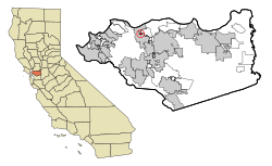
Rosedale is a census-designated place (CDP) in Kern County, California, United States. The population was 14,058 at the 2010 census, up from 8,445 at the 2000 census. Formerly a country town 10 miles (16 km) west of Bakersfield, it is now surrounded by suburban housing and currently has the highest household income in Kern County, according to Census estimates.

<span class="mw-page-title-main">Squirrel Mountain Valley, California</span> Census-designated place in California, United States

Squirrel Mountain Valley is a census-designated place (CDP) in the southern Sierra Nevadas, in Kern County, California, United States. Squirrel Mountain Valley is located in the Lake Isabella area 5 miles (8 km) northeast of Bodfish, at an elevation of 2,900 feet (883.9 m). The population was 547 at the 2010 census, up from 498 at the 2000 census.

<span class="mw-page-title-main">Valley Acres, California</span> Census-designated place in California, United States

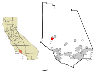
Valley Acres is a census-designated place (CDP) in Kern County, California, United States. Valley Acres is located 5.2 miles (8.4 km) north-northeast of Taft, at an elevation of 420 feet (128.02 m). The population was 527 at the 2010 census, up from 512 at the 2000 census.

<span class="mw-page-title-main">North El Monte, California</span> Census-designated place in California, United States

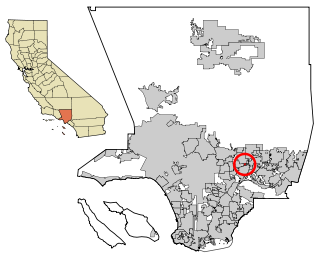
North El Monte is a census-designated place (CDP) in the San Gabriel Valley, in Los Angeles County, California, United States. The population was 3,723 at the 2010 census, up from 3,703 at the 2000 census.

<span class="mw-page-title-main">Lakeview, California</span> Census-designated place in California, United States

Lakeview is a census-designated place (CDP) in Riverside County, California, United States. The population was 2,104 at the 2010 census, up from 1,619 at the 2000 census. The community is named for nearby Mystic Lake.

<span class="mw-page-title-main">Crestline, California</span> Census-designated place in California, United States

Crestline is a census-designated place in the San Bernardino Mountains of San Bernardino County, California, USA. The population was 10,770 at the 2010 census, up from 10,218 at the 2000 census.

<span class="mw-page-title-main">Mountain View Acres, California</span> Census-designated place in California, United States

Mountain View Acres is a census-designated place (CDP) in the Victor Valley of the Mojave Desert, within San Bernardino County, California.

<span class="mw-page-title-main">Farmington, California</span> Census-designated place in San Joaquin, California

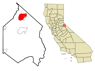
Farmington is a census-designated place (CDP) in San Joaquin County, California. The population was 172 at the 2020 census, down from 207 at the 2010 census.

<span class="mw-page-title-main">Mira Monte, California</span> Rural community in Ventura County, California, United States

Mira Monte is a rural community in Ventura County, California, United States. Mira Monte is located in between the communities of Oak View, Meiners Oaks, and southwest of the City of Ojai, California. For statistical purposes, the United States Census Bureau has defined Mira Monte as a census-designated place (CDP). The census definition of the area may not precisely correspond to local understanding of the area with the same name. According to the 2020 census, the population of Mira Monte is 6,618, down from 6,845 at the 2010 census.

<span class="mw-page-title-main">Mountain Park, Gwinnett County, Georgia</span> CDP in Georgia, United States

Mountain Park is an unincorporated, census-designated place in Gwinnett County, Georgia, United States. The population was 11,554 at the 2010 census. The older name for the area is Trickum, which is reflected in Five Forks-Trickum Road which bisects the community. The older community was centered on Five Forks and Rockbridge Roads.

<span class="mw-page-title-main">Stallion Springs, California</span> Census-designated place in California, United States

Stallion Springs is a census-designated place (CDP) in the Tehachapi Mountains, in Kern County, California, USA. The population was 2,488 at the 2010 census, up from 1,522 at the 2000 census. Stallion Springs is located in the greater Tehachapi Area.

<span class="mw-page-title-main">Vernon Valley, New Jersey</span> Populated place in Sussex County, New Jersey, US

Vernon Valley is an unincorporated community and census-designated place (CDP) located in Vernon Township, in Sussex County, in the U.S. state of New Jersey. As of the 2010 United States Census, the CDP's population was 1,626.

<span class="mw-page-title-main">West Mountain, Utah</span> CDP in Utah, United States

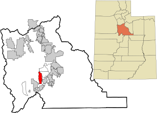
West Mountain is a census-designated place (CDP) in Utah County, Utah, United States. It is part of the Provo–Orem Metropolitan Statistical Area. As of the 2010 census, the CDP population was 1,186. The town is at the base of West Mountain and bears its name.

<span class="mw-page-title-main">Rib Mountain (CDP), Wisconsin</span> CDP in Wisconsin, United States

Rib Mountain is a census-designated place (CDP) in the town of Rib Mountain in Marathon County, Wisconsin, United States. The population was 6,061 at the 2020 census.

References

  1. "Senators". State of California. Retrieved March 30, 2013.
  2. "Members Assembly". State of California. Retrieved March 30, 2013.
  3. "California's 5th Congressional District - Representatives & District Map". Civic Impulse, LLC. Retrieved March 9, 2013.
  4. 1 2 "Mountain View". Geographic Names Information System . United States Geological Survey, United States Department of the Interior.
  5. 1 2 "Population and Housing Unit Estimates" . Retrieved June 9, 2017.
  6. "Census of Population and Housing". Census.gov. Retrieved June 4, 2016.
  7. "2010 Census Interactive Population Search: CA - Mountain View CDP". U.S. Census Bureau. Archived from the original on July 15, 2014. Retrieved July 12, 2014.
  8. "U.S. Census website". United States Census Bureau . Retrieved January 31, 2008.