
Easton is a census-designated place (CDP) in Fresno County, California, United States. The population was 2,083 at the 2010 census, up from 1,966 at the 2000 census. Easton is located 7.5 miles (12.1 km) south of downtown Fresno, at an elevation of 276 feet.

Cutten, a census-designated place (CDP) in Humboldt County, California, United States, is an unincorporated community, which is part of Greater Eureka. The city was named for David Page Cutten and his family, who were prominent figures in the history of Humboldt County during the early 1850s. Cutten is located 2.5 miles (4 km) south-southeast of downtown Eureka, at an elevation of 200 feet. Its population is 3,223 as of the 2020 census, up from 3,108 from the 2010 census.

West Bishop is a census-designated place (CDP) in Inyo County, California, United States. The population was 2,607 at the 2010 census, down from 2,807 at the 2000 census.

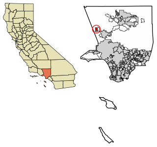
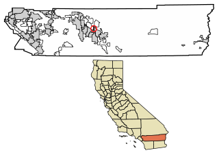
Vincent is a census-designated place (CDP) in the central San Gabriel Valley, in Los Angeles County, California, United States. The city name and zipcode for addresses south of Arrow Highway is Covina and 91722, respectively, and Azusa and 91702 for addresses north of Arrow Highway. The population was 15,922 at the 2010 census, up from 15,097 at the 2000 census. Vincent is named after Vincent Avenue, which passes through the community.

Parkwood is a census-designated place (CDP) in Madera County, California, United States. It is part of the Madera Metropolitan Statistical Area. The population was 2,307 at the 2020 census.

August is a census-designated place (CDP) in San Joaquin County, California, United States. The population was 8,628 at the 2020 census, up from 8,390 at the 2010 census.

Mission Canyon is a census-designated place and an unincorporated suburb of Santa Barbara, California, in Santa Barbara County, United States. The population was 2,381 at the 2010 census, down from 2,610 at the 2000 census.

Toro Canyon is a census-designated place (CDP) in Santa Barbara County, California, United States. The population was 1,835 at the 2020 census, up from 1,508 at the 2010 census.
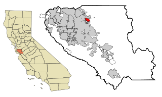
East Foothills is a census-designated place (CDP) in Santa Clara County, California, United States and a neighborhood of San Jose. The population was 8,269 at the 2010 census and it is located about 4 miles east of downtown San Jose.
Sisquoc is a census-designated place in Santa Barbara County, California located east of U.S. Route 101 about 15 miles (24 km) southeast of Santa Maria and 5 miles (8.0 km) south of Garey. The ZIP Code is 93454, and the community is inside area code 805. Sisquoc has a fire station, a church, a Preschool-8 school and a store. It has a micro-climate with mild weather year-round. The population was 183 at the 2010 census.
Alta is a small unincorporated community and census-designated place (CDP) in Placer County, California, United States, about 30 miles (48 km) northeast of Auburn. The village is located off Interstate 80 and along the historical First transcontinental railroad. The ZIP code is 95701 and the area code 530. One of the few buildings other than private residences is the Alta-Dutch Flat Grammar School serving kindergarten through eighth grade students. The high school that serves Alta is named Colfax High School. Colfax High School is 11 miles southwest in the incorporated town of Colfax. The population of Alta was 615 at the 2020 census.
Thornton is a census-designated place (CDP) in San Joaquin County, California, United States. Thornton is located along Interstate 5 7 miles (11 km) west-southwest of Galt. Thornton has a post office with ZIP code 95686.

Butte Creek Canyon is an unincorporated community and census-designated place (CDP) in Butte County, California. Butte Creek Canyon sits at an elevation of 1024 feet in the Sierra Nevada foothills. The 2010 United States census reported Butte Creek Canyon's population was 1,086. In November 2018, the Camp Fire destroyed a large portion of the town.
Camino Tassajara is a census-designated place in Contra Costa County, California. Camino Tassajara sits at an elevation of 814 feet (248 m). The 2010 United States census reported Camino Tassajara's population was 2,197.

Homewood Canyon is a census-designated place (CDP) in Inyo County, California. Homewood Canyon sits at an elevation of 3,074 feet (937 m). The 2010 United States census reported Homewood Canyon's population was 44.
Hasley Canyon is a census-designated place in the Sierra Pelona mountains of Los Angeles County, California. Hasley Canyon sits at an elevation of 1,765 feet (538 m). The 2010 United States census reported Hasley Canyon's population was 1,137.
Pine Canyon is an unincorporated community and census-designated place (CDP) in Monterey County, California, just south of King City. Pine Canyon sits at an elevation of 515 feet (157 m). As of the 2020 census, the population was 1,871.
Desert Palms is a census-designated place in the Coachella Valley of eastern Riverside County, southern California.

Lake Mathews is a census-designated place in Riverside County, California. Lake Mathews sits at an elevation of 1,775 feet (541 m). The 2010 United States census reported Lake Mathews's population was 5,890.

Linnell Camp is a census-designated place (CDP) in Tulare County, California. Linnell Camp sits at an elevation of 358 feet (109 m). The 2010 United States census reported Linnell Camp's population was 849.


