Portola Valley, California

Last updated

Portola Valley, California
Town of Portola Valley
OurLadyoftheWayside.jpg
Seal of Portola Valley, California.png
San Mateo County California Incorporated and Unincorporated areas Portola Valley Highlighted.svg
Location in San Mateo County and the state of California
Usa edcp relief location map.png
Red pog.svg
Portola Valley, California
Location in the United States
Coordinates: 37°22′30″N122°13′7″W / 37.37500°N 122.21861°W / 37.37500; -122.21861
CountryUnited States
State California
County San Mateo
Incorporated July 14, 1964 [1]
Named for Gaspar de Portolá
Government
   Mayor Maryann Derwin [2]
   Vice Mayor Craig Hughes [2]
Area
[3]
  Total9.08 sq mi (23.53 km2)
  Land9.08 sq mi (23.52 km2)
  Water0.00 sq mi (0.00 km2)  0.02%
Elevation
459 ft (140 m)
Population
 (2020) [4]
  Total4,456
  Density490/sq mi (190/km2)
Time zone UTC-8 (PST)
  Summer (DST) UTC-7 (PDT)
ZIP code
94028
Area code 650
FIPS code 06-58380
GNIS feature ID1659786
Website www.portolavalley.net

Portola Valley is a town in San Mateo County, California, United States. Located on the San Francisco Peninsula in the Bay Area, Portola Valley is a small, wealthy community nestled on the eastern slopes of the Santa Cruz Mountains. [5] [6]

Contents

History

Portola Valley is named after Gaspar de Portola, first Governor of the Californias and leader of the Portola expedition. Retrat Gaspar de Portola (Lleida).jpg
Portola Valley is named after Gaspar de Portolá, first Governor of the Californias and leader of the Portolá expedition.

Portola Valley was named for Spanish explorer Gaspar de Portolá, who led the first party of Europeans to explore the San Francisco Peninsula in 1769.

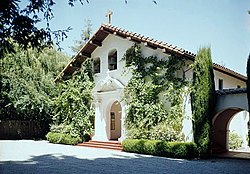
The Native Americans already present were Ohlone and specifically the group (or groups) known as Olpen or Guemelento but these were later moved to Mission Dolores and Mission Santa Clara de Asís which claimed the land and peoples. [7] [8] The area's written history dates back to 1833, when a square league of land was given to Domingo Peralta and Máximo Martínez by Governor José Figueroa to form the Rancho Cañada del Corte de Madera. [9] In those days it was used for lumbering and cattle grazing.

By the 1880s Andrew S. Hallidie, a wire rope manufacturer, had built his country home of Eagle Home Farm in what is now Portola Valley. He built a 7,341 foot long aerial tramway from his house to the top of Skyline in 1894 though it was removed after his death in 1900. [10] [11]

In 1886 the name Portola-Crespi Valley was bestowed on the area from the then community of Crystal Springs (now under Crystal Springs Reservoir to the then community of Searsville (in the area of the present day Jasper Ridge Biological Preserve); Crespi is for Juan Crespí, a Franciscan friar with the Portolà expedition.

The town was incorporated in 1964. [12] Bill Lane was the first mayor. [9]

In March 2024, Portola Valley became the first California city or town that had its housing plans to provide more legally required lower income housing decertifed by the California Department of Housing and Community Development for failure to take the necessary steps of rezoning to carry them out. [6]

Geography

Portola Valley is located on the San Francisco Peninsula on the eastern slope of the Santa Cruz Mountains. The town is west of Interstate 280 and the southwest boundary is along Skyline Boulevard which more or less is the ridge of the mountains. The Windy Hill Open Space Preserve is a large part of the town's southwest side and the north side of the town borders Jasper Ridge Biological Preserve. Woodside borders it to the northwest and Palo Alto to the southeast The unincorporated subdivision of Ladera is adjacent to the northern boundary of the town. It is in a mostly wooded area, with some open fields. The San Andreas Fault bisects the town. [13] [14]

Alpine Road and Portola Road are the two relatively main roads in the town and their intersection forms a small shopping nexus.

Portola Valley can generally be divided into 7 subdivisions: Central Portola Valley, The Ranch, Corte Madera, Los Trancos/Vista Verde, Woodside Highlands, Westridge, and Blue Oaks.

According to the United States Census Bureau, the town has a total area of 9.099 square miles (23.57 km2), 99.98% of it land and 0.02% of it water. [15]

Attractions

The historic Mission Revival style Portola Valley School, built 1909. Portola Valley School.jpg
The historic Mission Revival style Portola Valley School, built 1909.

Our Lady of the Wayside Church was built in 1912 for the local Catholic community and is a California Historic Landmark and on the U.S. National Register of Historic Places. [16] [17]

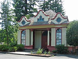
Portola Valley School is a one-room former school house built in 1909 and is on the U.S. National Register of Historic Places. [18] It is now used for town council meetings. [19]

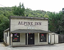
The Alpine Inn, also known as Casa de Tableta, Rossotti's or Zott's, is one of the oldest existing drinking establishments in California; it started around 1852 when Felix Buelna built it as a gambling house. [20] [21] The first two-network TCP/IP transmission was between a specialized SRI van and ARPANET on August 27, 1976; the van was parked next to the Alpine Inn and wires were run to one of the picnic tables. [22] [23] In 2018, the inn was acquired by new owners, who closed it temporarily for remodeling. [24] [25] [26] [27] It was re-opened in August 2019. [28]

Trails

Portola Valley is known for its expansive trail network both maintained by the town [29] and also in the Windy Hill Open Space Preserve maintained by the Midpeninsula Regional Open Space District. [30] [31] The trail network includes the 235 acre Coal Mine Ridge Nature Preserve which is private property, but, by agreement with the town is set aside as open space. [32] [33]

Demographics

Historical population
CensusPop.Note
1970 4,996
1980 3,939−21.2%
1990 4,1946.5%
2000 4,4626.4%
2010 4,353−2.4%
2020 4,4562.4%
U.S. Decennial Census [34] [35]

As of 2020, the town has a much higher percentage of white people than the rest of San Mateo county, with 75% being white as opposed to 35% in San Mateo county overall. [6] This is the result of their exclusionary zoning ordinances, which prohibit multifamily dwellings anywhere in the town. [6]

As of 2020 the median income per household in Portola Valley was estimated at $235,469 and the per capita income was $142,778. [5]

2010

The historic Casa de Tableta, built by Californio entrepreneur Felix Buelna in 1851, now named Rossotti's Alpine Inn. Casa de Tableta, Portola Valley, California.jpg
The historic Casa de Tableta, built by Californio entrepreneur Félix Buelna in 1851, now named Rossotti's Alpine Inn.

The 2010 United States Census [36] reported that Portola Valley had a population of 4,353. The population density was 478.7 inhabitants per square mile (184.8/km2). The racial makeup of Portola Valley was 3,960 (91.0%) White, 12 (0.3%) African American, 5 (0.1%) Native American, 242 (5.6%) Asian, 1 (0.0%) Pacific Islander, 29 (0.7%) from other races, and 104 (2.4%) from two or more races. Hispanic or Latino of any race were 175 persons (4.0%).

The Census reported that 4,309 people (99.0% of the population) lived in households, 9 (0.2%) lived in non-institutionalized group quarters, and 35 (0.8%) were institutionalized.

There were 1,746 households, out of which 518 (29.7%) had children under the age of 18 living in them, 1,149 (65.8%) were opposite-sex married couples living together, 70 (4.0%) had a female householder with no husband present, 35 (2.0%) had a male householder with no wife present. There were 37 (2.1%) unmarried opposite-sex partnerships, and 21 (1.2%) same-sex married couples or partnerships. 420 households (24.1%) were made up of individuals, and 290 (16.6%) had someone living alone who was 65 years of age or older. The average household size was 2.47. There were 1,254 families (71.8% of all households); the average family size was 2.93.

The population was spread out, with 1,001 people (23.0%) under the age of 18, 145 people (3.3%) aged 18 to 24, 538 people (12.4%) aged 25 to 44, 1,496 people (34.4%) aged 45 to 64, and 1,173 people (26.9%) who were 65 years of age or older. The median age was 51.3 years. For every 100 females, there were 98.4 males. For every 100 females age 18 and over, there were 91.2 males.

There were 1,895 housing units at an average density of 208.4 per square mile (80.5/km2), of which 1,392 (79.7%) were owner-occupied, and 354 (20.3%) were occupied by renters. The homeowner vacancy rate was 1.0%; the rental vacancy rate was 9.8%. 3,702 people (85.0% of the population) lived in owner-occupied housing units and 607 people (13.9%) lived in rental housing units.

2000

As of the census [37] of 2000, there were 4,392 people, 1,772 households, and 1,269 families residing in the town. The population density was 487.5 inhabitants per square mile (188.2/km2). There were 1,772 housing units at an average density of 193.6 per square mile (74.7/km2). The racial makeup of the town was 4,210 White, 29 African American, 22 Native American, 217 Asian, 5 Pacific Islander, 54 from other races, and 64 from two or more races. Hispanic or Latino of any race were 149.

There were 1,772 households, out of which 532 had children under the age of 18 living with them, 1,176 were married couples living together, 68 had a woman householder with no man present, and 431 were non-families. 339 of all households were made up of individuals, and 226 had someone living alone who was 65 years of age or older. The average household size was 2.75 and the average family size was 2.93.

In the town the age distribution of the population shows 1021 persons under the age of 18, 90 from 20 to 24, 867 from 25 to 44, 1492 from 45 to 64, and 938 who were 65 years of age or older. The median age was 47.5 years old. For every 100 women there were 96.8 men. For every 100 women age 18 and over, there were 91.7 men.

The median income for a household in Portola Valley, including earnings, is $244,771 and the median income for a family was $180,893. Men have a median income of over $200,000 versus $172,585 for women. The per capita income for Portola Valley is $152,128. About 18 families and 104 people were below the poverty line, including 38 of those under age 18 and none of those age 65 or over.

Education

Woodside Priory School. Woodside Priory School graduation procession 2008.jpg
Woodside Priory School.

The Portola Valley Elementary School District has two public primary schools: Ormondale School (with grades K–3) and Corte Madera School (grades 4–8). The public high school is Woodside High School, part of the Sequoia Union High School District and in the neighboring community of Woodside. [38] Ormondale is named for the Ormondale ranch that had covered much of present-day Westridge, Oak Hills, and Ladera and was home to the famous English racehorse, Ormonde, in his later years. [39]

Portola Valley is also home to two private schools: Woodside Priory School, an independent college-preparatory Roman Catholic day and boarding school serving grades 6-12, and Woodland School, an independent pre-K-8 grade school. [38]

The city is served by the Portola Valley Public Library of the San Mateo County Libraries, a member of the Peninsula Library System. [40]

Government

Portola Valley Library. Library in the Landscape -- The Portola Valley Library (12422097064).jpg
Portola Valley Library.

In the California State Legislature, Portola Valley is in the 13th Senate District , represented by Democrat Josh Becker, and in the 23rd Assembly District , represented by Democrat Marc Berman. [41]

Federally, Portola Valley is in California's 16th congressional district , represented by Democrat Anna Eshoo. [42] Politically, Portola Valley leans slightly Democratic based on voting patterns for past presidential elections. [43]

Portola Valley is part of the Woodside Fire Protection District (which also covers Woodside, Ladera, Emerald Hills, Los Trancos, Skyline, and Viste Verde), which has one its three stations in the town. [44]

For law enforcement, Portola Valley contracts with the San Mateo County Sheriff's Office.

The Portola Valley Town Council made up of volunteers elected for four year terms governs the town. It appoints a town manager and other necessary officers and also elects a mayor. [45]

Notable people

Related Research Articles

<span class="mw-page-title-main">San Mateo County, California</span> County in California, United States

San Mateo County, officially the County of San Mateo, is a county in the U.S. state of California. As of the 2020 census, the population was 764,442. Redwood City is the county seat, the third-most populated city in the county after Daly City and San Mateo.

<span class="mw-page-title-main">Menlo Park, California</span> City in California, United States

Menlo Park is a city at the eastern edge of San Mateo County within the San Francisco Bay Area of California, United States. It is bordered by San Francisco Bay on the north and east; East Palo Alto, Palo Alto, and Stanford to the south; and Atherton, North Fair Oaks, and Redwood City to the west. It had 33,780 residents at the 2020 United States census. It is home to the corporate headquarters of Meta, and is where Google, Roblox Corporation and Round Table Pizza were founded. The train station holds the record as the oldest continually operating train station in California. It is one of the most educated cities in California and the United States; nearly 70% of residents over 25 have earned a bachelor's degree or higher.

<span class="mw-page-title-main">Kirkwood, California</span> Place in California, United States

Kirkwood is an unincorporated community in Alpine and Amador counties, California, United States. Kirkwood's main attraction is the Kirkwood Mountain Resort. The town is accessible by State Route 88. Kirkwood is within the Eldorado National Forest. The population was 158 at the 2010 census. For statistical purposes, the United States Census Bureau has defined Kirkwood as a census-designated place (CDP).

<span class="mw-page-title-main">Portola, California</span> City in California, United States

Portola is the only incorporated city in Plumas County, California, United States. The population was 2,104 at the 2010 census, down from 2,227 at the 2000 census. Portola is located on the Middle Fork of the Feather River and was named after Spanish explorer Gaspar de Portolá, although he did not explore this area.

<span class="mw-page-title-main">Atherton, California</span> Town in San Mateo County, California

Atherton is an incorporated town in San Mateo County, California, United States. Its population was 7,188 as of 2020. The town's zoning regulations permit only one single-family home per acre, and prohibit sidewalks.

<span class="mw-page-title-main">Belmont, California</span> City in the US state of California

Belmont is a city in San Mateo County in the U.S. state of California. It is in the San Francisco Bay Area, on the San Francisco Peninsula about halfway between San Francisco and San Jose. Known for its wooded hills, views of the San Francisco Bay and stretches of open space, Belmont is a quiet residential community in the midst of the culturally and technologically rich Bay Area. It was originally part of Rancho de las Pulgas, for which one of its main roads, the Alameda de las Pulgas, is named. The city was incorporated in 1926. Its population was 28,335 at the 2020 census.

<span class="mw-page-title-main">Daly City, California</span> City in California, United States

Daly City is the second most populous city in San Mateo County, California, United States. The population was 104,901 at the 2020 census. Located in the San Francisco Bay Area, and immediately south of San Francisco, it is named for businessman and landowner John Donald Daly.

<span class="mw-page-title-main">East Palo Alto, California</span> City in California, United States

East Palo Alto is a city in San Mateo County, California, United States. As of the 2020 census, the population of East Palo Alto was 30,034. It is situated on the San Francisco Peninsula, roughly halfway between the cities of San Francisco and San Jose. To the north and east is the San Francisco Bay, to the west is the city of Menlo Park, and to the south the city of Palo Alto. The city is directly north of Palo Alto. East Palo Alto was founded as an unincorporated community and incorporation in July 1983. The two cities are separated only by San Francisquito Creek and, largely, the Bayshore Freeway. The revitalization projects in 2000, and high income high-tech professionals moving into new developments, including employees from Google and Facebook, have begun to slowly eliminate the historically wide cultural and economic differences between the two cities. East Palo Alto and Palo Alto share both telephone area codes and postal ZIP codes.

<span class="mw-page-title-main">Foster City, California</span> City in California, United States

Foster City is a master-planned city located in San Mateo County, California, United States. Foster City is sometimes considered to be part of Silicon Valley for its local industry and its proximity to Silicon Valley cities. There are many notable companies headquartered in Foster City like Gilead Sciences, Zoox, Sledgehammer Games, and Replit. Visa used to be headquartered in Foster City.

<span class="mw-page-title-main">Half Moon Bay, California</span> City in California, United States

Half Moon Bay is a coastal city in San Mateo County, California, United States, approximately 25 miles south of San Francisco. Its population was 11,795 as of the 2020 census. Immediately north of Half Moon Bay is Pillar Point Harbor and the unincorporated community of Princeton-by-the-Sea. Half Moon Bay is known for Mavericks, a big-wave surf location. It is called Half Moon Bay because of its crescent shape.

<span class="mw-page-title-main">Hillsborough, California</span> City in California, United States

Hillsborough is an incorporated town in San Mateo County, California, United States, in the San Francisco Bay Area. It is located 17 miles (27 km) south of San Francisco on the San Francisco Peninsula, bordered by Burlingame to the north, San Mateo to the east, Highlands-Baywood Park to the south, and Interstate 280 to the west. The population was 11,387 at the 2020 census.

<span class="mw-page-title-main">Millbrae, California</span> City in California, United States

Millbrae is a city located in northern San Mateo County, California, United States. To the northeast is San Francisco International Airport; San Bruno is to the northwest, and Burlingame is to the southeast. It is bordered by San Andreas Lake to the southwest. The population was 23,216 at the 2020 census.

<span class="mw-page-title-main">Pacifica, California</span> City in San Mateo County, California, US

Pacifica is a city in San Mateo County, California, on the coast of the Pacific Ocean between San Francisco and Half Moon Bay.

<span class="mw-page-title-main">Redwood City, California</span> City in the United States

Redwood City is a city on the San Francisco Peninsula in Northern California's Bay Area, approximately 27 miles (43 km) south of San Francisco, and 24 miles (39 km) northwest of San Jose. Redwood City's history spans its earliest inhabitation by the Ohlone people to being a port for lumber and other goods. The county seat of San Mateo County in the heart of Silicon Valley, Redwood City is home to several global technology companies including Oracle, Electronic Arts, Evernote, Box, and Informatica. The city's population was 84,292 according to the 2020 census. The Port of Redwood City is the only deepwater port on San Francisco Bay south of San Francisco.

<span class="mw-page-title-main">San Bruno, California</span> City in California, United States

San Bruno is a city in San Mateo County, California, United States, incorporated in 1914. The population was 43,908 at the 2020 United States Census. The city is between South San Francisco and Millbrae, adjacent to San Francisco International Airport and Golden Gate National Cemetery; it is approximately 12 miles (19 km) south of Downtown San Francisco.

<span class="mw-page-title-main">San Carlos, California</span> City in California, United States

San Carlos is a city in San Mateo County, California, United States. The population is 30,722 per the 2020 census.

<span class="mw-page-title-main">Woodside, California</span> Town in California, United States

Woodside is a small incorporated town in San Mateo County, California, United States, on the San Francisco Peninsula. It has a council–manager system of government.

<span class="mw-page-title-main">Los Altos Hills, California</span> City in California, United States

Los Altos Hills is an incorporated town in Santa Clara County, California, United States. The population was 8,489 at the 2020 census. The town is known for its affluence and expensive residential real estate.

<span class="mw-page-title-main">La Honda, California</span> Census-designated place in California, United States

La Honda is a census-designated place (CDP) in southern San Mateo County, California, United States. The population was 979 at the 2020 census. It is located in the Santa Cruz Mountains between the Santa Clara Valley and California's Pacific coast. La Honda is near the La Honda Creek Open Space Preserve and State Route 84 on the ocean side of the Coastal Range.

<span class="mw-page-title-main">Ladera, California</span> Census-designated place in California, United States

Ladera is a census-designated place (CDP) in southern San Mateo County, California, adjacent to Portola Valley. Primarily a residential community, it comprises approximately 520 homes, governed by the Ladera Community Association. The ZIP Code is 94028 and the community is inside area code 650. The population was 1,557 at the 2020 census.

References

  1. "California Cities by Incorporation Date" (Word). California Association of Local Agency Formation Commissions . Retrieved August 25, 2014.
  2. 1 2 "Town Council". Portola Valley, CA. Retrieved December 19, 2014.
  3. "2019 U.S. Gazetteer Files". United States Census Bureau. Retrieved July 1, 2020.
  4. "Census Data: Portola Valley (town)". United States Census Bureau . Retrieved July 14, 2021.
  5. 1 2 "94028 Income Statistics - Current Census Data for Zip Codes". www.incomebyzipcode.com. Retrieved April 26, 2022.
  6. 1 2 3 4 Talerico, Kate (April 2, 2024). "A wealthy Peninsula town is dragging its feet on building housing, state says. Now, it faces consequences. - The town is the first to have its housing element decertified by the state, which means it loses out on key state infrastructure funds". San Jose Mercury News . Historically, Portola Valley hasn't allowed multifamily housing complexes to be built in town. As a result, the community is a homogenous enclave: 75% white (compared to 35% in San Mateo county overall), with a median household income of $250,000 and an average home value of $3.8 million. As of 2020, 81% of the town's housing stock was made up of single-family homes, many on lots of an acre or larger.
  7. Millikan, Randally; Shoup, Laurence H.; Ortiz, Beverley R. (June 2009). Ohlone/Costanoan Indians of the San Francisco Peninsula and their Neighbors, Yesterday and Today (PDF). National Park Service. pp. 293–294.
  8. Bocek, Barbara (1992). "Subsistence, Settlement and Tribelet Territories on the Eastern San Francisco Peninsula" (PDF). Proceedings of the Society for California Arhchaeology. 5: 269–297. Retrieved April 8, 2018.
  9. 1 2 Kyle, Douglas E.; Rensch, Hero Eugene; Rensch, Ethel Grace; Hoover, Mildred Brooke (2002). Historic Spots in California: Fifth Edition. Stanford University Press. ISBN   9780804778176 . Retrieved March 24, 2018.
  10. Clifford, Jim (May 8, 2017). "Cable car inventor built tram in Portola Valley". San Mateo Daily Journal. Retrieved March 25, 2018.
  11. "Hallidie Tramway - Portola Valley, CA - Signs of History on Waymarking.com". www.waymarking.com. Retrieved March 25, 2018.
  12. "Portola Valley, CA : History of Portola Valley". www.portolavalley.net. Retrieved March 16, 2017.
  13. Aiden, Andrew (August 8, 2013). "Lost and Found: The 1906 Earthquake Rupture in Portola Valley". KQED. Retrieved March 25, 2018.
  14. "Geologic Map: Town of Portola Valley". Portola Valley. Cotton, Shires, and Associates. June 2017. Retrieved March 25, 2018.
  15. "2016 U.S. Gazetteer Files". United States Census Bureau. Retrieved June 28, 2017.
  16. California, California State Parks, State of. "OUR LADY OF THE WAYSIDE". CA State Parks. Retrieved March 29, 2018.{{cite web}}: CS1 maint: multiple names: authors list (link)
  17. "National Register #77000338: Our Lady of the Wayside in Portola Valley, California". noehill.com. Retrieved March 29, 2018.
  18. "National Register #74000557: Portola Valley School, California". noehill.com. Retrieved March 29, 2018.
  19. "Town Center: Portola Valley, CA". www.portolavalley.net. Retrieved March 29, 2018.
  20. Staiger, Steve (January 24, 2001). "Echoes of Alpine Inn's early days". www.paloaltoonline.com. Retrieved March 29, 2018.
  21. "Buelna's Roadhouse, 3915 Alpine Road, Portola Valley, San Mateo County, CA". The Library of Congress. Retrieved March 29, 2018.
  22. Laws, David (April 13, 2012). "Alpine Inn & Beer Garden". Silicon Valley Roots & Shoots. Archived from the original on September 19, 2013. Retrieved March 31, 2013.
  23. SRI Mobile Van | X1590.99 | Computer History Museum. 1977. Retrieved May 30, 2018.{{cite book}}: |website= ignored (help)
  24. "Popular burger joint is closed until March for remodeling". www.almanacnews.com. Retrieved February 19, 2018.
  25. "Portola Valley: Alpine Inn has new owners".
  26. Daly, Kate. "Historic Alpine Inn reopening in Portola Valley on Friday". www.paloaltoonline.com. Retrieved December 31, 2019.
  27. Gulker, Linda Hubbard (December 30, 2019). "The saga of Alpine Inn aka Zott's over the years — InMenlo". InMenlo.com.
  28. Daly, Kate. "Historic Alpine Inn reopening in Portola Valley on Friday". www.paloaltoonline.com. Retrieved April 8, 2021.
  29. "Portola Valley Trails". Town of Portola Valley. Retrieved March 22, 2018.
  30. "Windy Hill Preserve". Midpeninsula Regional Open Space District. Retrieved April 26, 2022.
  31. "Town of Portola Valley, San Mateo County". Bay Area Hikers. Retrieved April 26, 2022.
  32. "Coal Mine Ridge Nature Preserve | Portola Valley CA". CMRNP. Retrieved April 26, 2022.
  33. "Coal Mine Ridge Nature Preserve, Portola Ranch Homeowner's Association, San Mateo County". Bay Area Hikers. Retrieved April 26, 2022.
  34. "Census of Population and Housing". Census.gov. Retrieved June 4, 2015.
  35. "2020 Explore Census Data". data.census.gov. Retrieved April 23, 2022.
  36. "2010 Census Interactive Population Search: CA - Portola Valley town". U.S. Census Bureau. Archived from the original on July 15, 2014. Retrieved July 12, 2014.
  37. "U.S. Census website". United States Census Bureau . Retrieved January 31, 2008.
  38. 1 2 "Local Schools: Portola Valley, CA". www.portolavalley.net. Town of Portola Valley. Retrieved March 29, 2018.
  39. "The Incorporation of Portola Valley – Part 1". Portola Valley, Past and Present. January 14, 2014. Retrieved March 29, 2018.
  40. "Portola Valley Library" . Retrieved March 29, 2018.
  41. "Statewide Database". UC Regents. Archived from the original on February 1, 2015. Retrieved December 19, 2014.
  42. "California's 16th Congressional District - Representatives & District Map". Civic Impulse, LLC. Retrieved March 13, 2013.
  43. Schleuss, Jon; Fox, Joe; Krishnakumar, Priya. "California neighborhood election results: Did your precinct vote to elect Hillary Clinton or Donald Trump?". www.latimes.com. Retrieved March 22, 2018.
  44. "About - Woodside Fire Protection District". www.woodsidefire.org. Retrieved June 2, 2018.
  45. "Portola Valley Municipal Code". Municode Library. Retrieved June 2, 2018.
  46. Mangalindan, JP (July 7, 2014). "The secretive billionaire who built Silicon Valley" . Fortune. Retrieved March 9, 2020.
  47. Meetings of the Architectural Site Control Commission (Report). Town of Portola Valley. July 23, 2018. p. 84. Retrieved March 9, 2020.
  48. Marion Softky (February 8, 2006). "Author Don Nielson chronicles SRI research achievements". The Almanac. Retrieved December 23, 2017.
  49. Terry, Mike (February 8, 2003). "It's Good Move for Craig" . Los Angeles Times. Retrieved March 9, 2020.
  50. John Markoff (June 21, 2008). "Hewitt D. Crane, 81, Early Computer Engineer, Is Dead". The New York Times . Retrieved May 25, 2010.
  51. "Guide to the Richard and Mildred Crooks Collection". Online Archive of California. Retrieved March 9, 2020.
  52. Freeman, William M. (October 1, 1972). "Richard Crooks, Tenor at the Met, Dies" . The New York Times. Retrieved March 9, 2020.
  53. Crum, Rex (March 31, 2017). "Former eBay CEO John Donahoe is in the clouds at ServiceNow". San Jose Mercury News. Retrieved March 9, 2020.
  54. "Portola Valley entrepreneur named to open space trust board". The Almanac. March 3, 2009. Retrieved March 9, 2020.
  55. "Piano phenom Taylor Eigsti returns to Priory for anniversary concert". The Almanac. March 15, 2018. Retrieved March 9, 2020.
  56. Berlin, Linda; Chronicle, Special to The (October 5, 2001). "Profile / Thomas Fogarty / Stanford doctor to be honored for inventions". SFGate. Retrieved February 1, 2019.
  57. Collins, Glenn (October 18, 1991). "Tennessee Ernie Ford Dies at 72; Folksy Singer Recorded '16 Tons'". The New York Times. ISSN   0362-4331 . Retrieved February 16, 2018. He was 72 years old and lived in Portola Valley, near Palo Alto, Calif.
  58. "Billionaire Reid Hoffman gives candidate Josh Becker a $500,000 boost". The Daily Post. January 27, 2020. Retrieved March 9, 2020.
  59. Laurance Zuckerman (June 2, 1996). "Cuthbert Hurd, 85, Computer Pioneer at I.B.M". New York Times . Retrieved May 24, 2010.
  60. Saratoga Horticultural Research Foundation (2003). "Manzanita introductions of the Saratoga Horticultural Foundation" (PDF). Retrieved May 25, 2010.
  61. Mufson, Steven (November 28, 2014). "Billionaire Vinod Khosla's big dreams for biofuels fail to catch fire" . The Washington Post. Retrieved March 9, 2020.
  62. Lisa Kwiatkowski (February 25, 2005). "Bill Lane makes a gift of $5 million to endow Stanford's Center for the Study of the North American West". Stanford University . Retrieved May 24, 2010.
  63. "Bucolic Portola Valley Home to Famous Figures". SFGate. Retrieved March 22, 2018.
  64. Whiting, Sam (June 8, 2003). "Heads Above the Rest / Bruce Wolfe on the method and madness of sculpture". San Francisco Chronicle. Retrieved March 4, 2020.
  65. Military Vehicle Technology Foundation
  66. "Ex-Marine, Republican, War Critic Paul Norton McCloskey Jr" . The New York Times. April 12, 1971. Retrieved March 9, 2020.
  67. "Documentary salutes Pete McCloskey tonight". The Almanac. July 1, 2009. Retrieved March 9, 2020.
  68. Almond, Elliott (October 27, 2016). "Will Maverick McNealy live up to his name, eschew pro golf for loftier goals?". San Jose Mercury News. Bay Area News Group. Retrieved March 9, 2020.
  69. "Stanford grad McNealy makes the cut, earns PGA Tour Card". Palo Alto Online. August 12, 2019. Retrieved March 9, 2020.
  70. "Posh Home Of Silicon Valley Pioneer Site Of Trump Bay Area Fundraiser". CBS SF BayArea. September 17, 2019. Retrieved March 9, 2020.
  71. Graff, Amy (October 17, 2019). "$42 million price cut on tech billionaire's Silicon Valley monster mansion". SFGate. Retrieved March 9, 2020.
  72. "Woman found under bridge was daughter of former Portola Valley mayor; service Feb. 20". The Almanac. February 10, 2010. Retrieved March 9, 2020.
  73. Meetings of the Architectural Site Control Commission (Report). Town of Portola Valley. March 25, 2019. p. 1. Retrieved March 9, 2020.