La Honda, California

Last updated

La Honda
La Honda.png
State Route 84 in downtown La Honda
San Mateo County California Incorporated and Unincorporated areas La Honda Highlighted 0639318.svg
Location of La Honda in San Mateo County, California.
USA California location map.svg
Red pog.svg
La Honda
Location within the state of California
Usa edcp location map.svg
Red pog.svg
La Honda
La Honda (the United States)
Coordinates: 37°19′9″N122°16′27″W / 37.31917°N 122.27417°W / 37.31917; -122.27417
CountryUnited States
State California
County San Mateo
Area
[1]
  Total4.262 sq mi (11.038 km2)
  Land4.247 sq mi (10.999 km2)
  Water0.015 sq mi (0.039 km2)  0.35%
Elevation
[2]
715 ft (218 m)
Population
 (2020) [3]
  Total979
  Density230/sq mi (89/km2)
Time zone UTC-8 (Pacific (PST))
  Summer (DST) UTC-7 (PDT)
ZIP codes
94020 [4]
Area code 650
FIPS code 06-39318
GNIS feature ID2628746

La Honda (Spanish for "The Sling") [5] is a census-designated place (CDP) in southern San Mateo County, California, United States. [2] The population was 979 at the 2020 census. It is located in the Santa Cruz Mountains between the Santa Clara Valley and California's Pacific coast. La Honda is near the La Honda Creek Open Space Preserve and State Route 84 on the ocean side of the Coastal Range.

Contents

The ZIP Code for La Honda is 94020 and the area code is 650. Land-line numbers in the La Honda telephone exchange follow the pattern 747-xxxx while wired telephones in and around the Middleton Tract (along Portola State Park Road) work out of the Los Altos exchange with 94x-xxxx numbers. Per the U.S. Geological Survey, Lahonda is a historic variant of the modern spelling.

Geography

According to the United States Census Bureau, the CDP covers an area of 4.3 square miles (11.0 km2), 99.65% of it land, and 0.35% of it water.

Habitat

La Honda is home to diverse habitats, from cool, moist forests of coast redwood and coast Douglas fir, to mixed woodland, chaparral, and grassy hillsides.

Climate

2013 reconstruction of Scenic Drive after 2005's landslide. Scenic Drive reconstruction in La Honda - September 2013.png
2013 reconstruction of Scenic Drive after 2005's landslide.

This region experiences warm (but not hot) and dry summers, with no average monthly temperatures above 71.6 °F (22.0 °C). According to the Köppen Climate Classification system, La Honda has a warm-summer Mediterranean climate, abbreviated "Csb" on climate maps. [6] In addition, like much of California, the town receives most of its rain between November and April. Due to El Niño, the region sometimes receives extra winter rains, making it vulnerable to landslides. Scenic Drive, a local road, has seen three landslides since 1998. [7] [8] [9] With elevations ranging from about 300 feet where La Honda Creek meets Alpine Creek, to more than 1200 feet in the hills, the weather may vary between the town's hillsides and valleys. Sometimes the marine layer is too low to reach the hills, leaving the lower elevations foggy or overcast while the mountains enjoy clearer weather. On some winter nights, similar thermal inversions trap cold air in the valleys, leading to frost, with higher elevations remaining generally milder. These same weather patterns are at play in much of the coast-facing Santa Cruz Mountains.

Demographics

Historical population
CensusPop.Note
2010 928
2020 9795.5%
U.S. Decennial Census [10]

The 2010 United States Census [11] reported that La Honda had a population of 928. The population density was 217.7 inhabitants per square mile (84.1/km2). The racial makeup of La Honda was 811 (87.4%) White, 13 (1.4%) African American, 0 (0.0%) Native American, 16 (1.7%) Asian, 2 (0.2%) Pacific Islander, 18 (1.9%) from other races, and 68 (7.3%) from two or more races. Hispanic or Latino of any race were 69 persons (7.4%).

The Census reported that 916 people (98.7% of the population) lived in households, 0 (0%) lived in non-institutionalized group quarters, and 12 (1.3%) were institutionalized.

There were 411 households, out of which 98 (23.8%) had children under the age of 18 living in them, 203 (49.4%) were opposite-sex married couples living together, 31 (7.5%) had a female householder with no husband present, 16 (3.9%) had a male householder with no wife present. There were 40 (9.7%) unmarried opposite-sex partnerships, and 10 (2.4%) same-sex married couples or partnerships. 101 households (24.6%) were made up of individuals, and 16 (3.9%) had someone living alone who was 65 years of age or older. The average household size was 2.23. There were 250 families (60.8% of all households); the average family size was 2.64.

The chronological age of residents was spread out, with 153 people (16.5%) under the age of 18; 50 people (5.4%) aged 18 to 24; 202 people (21.8%) aged 25 to 44; 442 people (47.6%) aged 45 to 64; and 81 people (8.7%) who were 65 years of age or older. The median age was 47.6 years. For every 100 females, there were 113.8 males. For every 100 females age 18 and over, there were 107.8 males.

There were 472 housing units at an average density of 110.8 per square mile (42.8/km2), of which 293 (71.3%) were owner-occupied, while 118 (28.7%) were occupied by renters. The homeowner vacancy rate was 2.3%; the rental vacancy rate was 3.3%. A reported 689 people (74.2% of the population) lived in owner-occupied housing units, and 227 people (24.5%) lived in rental housing units.

Early history

Portion of Rancho Canada de Raymundo map showing La Honda Creek headwaters in 1856 La Honda Creek Headwaters 1856.tif
Portion of Rancho Cañada de Raymundo map showing La Honda Creek headwaters in 1856

The Ohlone lived in San Mateo County for at least 3,000 years prior to European arrival and had more than 40 communities in the region. The La Honda Ohlone were hunter gatherers and lived without farming or herd animals. [12]

The creek that runs through the town is listed as Arroyo Ondo on several diseños on the Mexican land grants and as Arroyo Hondo on the 1856 Rancho Cañada de Raymundo map. Hondo is Spanish for 'deep'. The post office was listed as La Honda in 1880 and revised to Lahonda after 1895. The name was restored in 1905 owing to Z. S. Eldredge's efforts. [13]

In 1862 John Howell Sears purchased 400 acres and settled in La Honda after his prior residence in Searsville was sold to the water company due to the decline of lumber and flooding issues. [12] The early days of La Honda were built around the lumber industry and the Old Store at La Honda was one of the earliest buildings.

Recent history

Ken Kesey, the author of One Flew Over the Cuckoo's Nest (pages of which were written all over the restroom wall of his La Honda residence) and other books, owned a home in La Honda, which served as the base of operations for The Merry Pranksters where they used LSD and other drugs. [14] The escapades of Kesey and the Merry Pranksters are documented in Tom Wolfe's The Electric Kool-Aid Acid Test , which describes the wildly painted school bus, 'Furthur', [15] driven by Neal Cassady, who had been the hyperkinetic driver in Jack Kerouac's On the Road .

A neon sign in the Redwoods: Applejack's Saloon. Apple Jacks La Honda CA.PNG
A neon sign in the Redwoods: Applejack's Saloon.

The La Honda house where Kesey's adventures became famous—one mile (1.6 km) west of Apple Jack's Inn—has been faithfully restored after years of neglect and a near-catastrophic flood in 1998.

La Honda Playground. La Honda Playground w Slides.jpg
La Honda Playground.

Schools

The town has a single school, La Honda Elementary, located within the La Honda-Pescadero Unified School District.

Festivals

The town hosts the La Honda Fair & Music Festival every June, and holds an annual Fourth of July picnic at Play Bowl.

Notable residents

See also

Related Research Articles

<span class="mw-page-title-main">El Sobrante, Contra Costa County, California</span> Census-designated place in United States

El Sobrante is a census-designated place (CDP) in Contra Costa County, California, United States. The population was 12,669 at the 2010 census.

<span class="mw-page-title-main">Pacheco, California</span> Census-designated place in California, United States

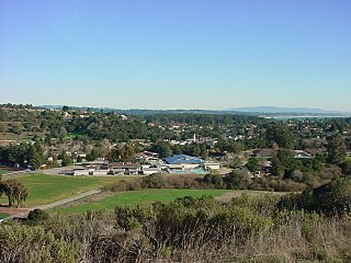
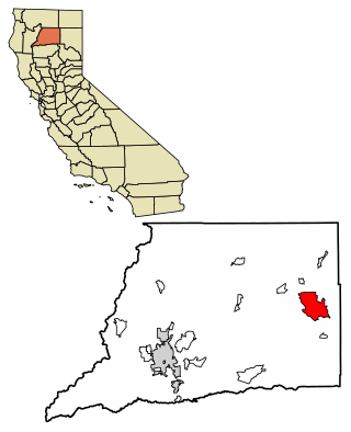
Pacheco is a census-designated place (CDP) in Contra Costa County, California. The population was 3,685 at the 2010 census. It is bounded by Martinez to the north and west, Concord to the east, and Pleasant Hill to the south.

<span class="mw-page-title-main">Cantua Creek, California</span> Census-designated place in California, United States

Cantua Creek is a census-designated place (CDP) in Fresno County, California, United States. As of the 2010 census, the population was 466, down from the 655 reported at the 2000 census. Cantua Creek is located 11 miles (18 km) south-southwest of Tranquillity, at an elevation of 295 feet.

<span class="mw-page-title-main">Willow Creek, California</span> Census-designated place in California, United States

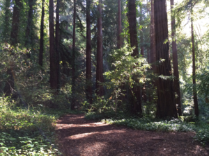
Willow Creek is a census-designated place (CDP) in Humboldt County, California, United States. The population was 1,710 at the 2010 census, down from 1,743 at the 2000 census. Residents of this small mountain town are commonly referred to as "Willow Creekers." The town is located around 30 miles (48 km) from county seat and harbor city Eureka, with the two places vastly differing in climate.

<span class="mw-page-title-main">Olancha, California</span> Census designated place in California, United States

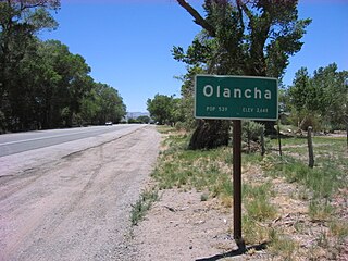
Olancha is a census designated place in Inyo County of the U.S. state of California. Olancha is located on U.S. Route 395 in California, 37 miles (60 km) south-southeast of Independence, at an elevation of 3658 feet. As of the 2010 census, the population was 192, up from 134 at the 2000 census.

<span class="mw-page-title-main">Shoshone, California</span> Census designated place in California, United States

Shoshone is a census designated place (CDP) in Inyo County, California, United States. The population was 22 at the 2020 census, down from 31 at the 2010 census.

<span class="mw-page-title-main">Lagunitas-Forest Knolls, California</span> Census-designated place in California, United States

Lagunitas-Forest Knolls is a census-designated place, composed of two unincorporated areas in the western half of the San Geronimo Valley in Marin County, California. It is located to the west of San Geronimo and Woodacre. The population was 1,924 at the 2020 census.

<span class="mw-page-title-main">Covelo, California</span> Census-designated place in California, United States

Covelo is a census-designated place (CDP) in Mendocino County, California, United States. Covelo is located 14 miles (23 km) east-northeast of Laytonville, at an elevation of 1,398 feet (426 m). The population was 1,394 at the 2020 census, up from 1,255 at the 2010 census. 405 acres (1.64 km2) of Covelo is part of the Round Valley Indian Reservation.

<span class="mw-page-title-main">La Porte, California</span> Census-designated place in California, United States

La Porte is a census-designated place (CDP) in Plumas County, California, United States. The population was 26 at the 2010 census, down from 43 at the 2000 census. The town was first known as Rabbit Creek.

<span class="mw-page-title-main">Pine Valley, California</span> Census-designated place in California, United States

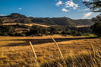
Pine Valley is a community and census-designated place (CDP) in the Cuyamaca Mountains of the Mountain Empire area, in southeastern San Diego County, California. The population was 1,510 at the 2010 census, up from 1,501 at the 2000 census.

<span class="mw-page-title-main">Soquel, California</span> Census-designated place in California, United States

Soquel is an unincorporated town and census-designated place (CDP) in Santa Cruz County, California, located on the northern coast of Monterey Bay. The population was 9,980 at the 2020 census.

The Merry Pranksters were followers of American author Ken Kesey. Kesey and the Merry Pranksters lived communally at Kesey's homes in California and Oregon, and are noted for the sociological significance of a lengthy road trip they took in the summer of 1964, traveling across the United States in a psychedelic painted school bus called Furthur, organizing parties, and giving out LSD. During this time they met many of the guiding lights of the 1960s cultural movement and presaged what are commonly thought of as hippies with odd behavior, tie-dyed and red, white, and blue clothing, and renunciation of normal society, which they dubbed The Establishment. Tom Wolfe chronicled their early escapades in his 1968 book The Electric Kool-Aid Acid Test, and documents a 1966 trip on Furthur from Mexico through Houston, stopping to visit Kesey's friend the novelist Larry McMurtry. Kesey was in flight from a drug charge at the time.

<span class="mw-page-title-main">Loma Mar, California</span> Census-designated place in California, United States

Loma Mar is a census-designated place (CDP) in San Mateo County, California. It is near San Mateo County Memorial Park on Pescadero Creek Road and is in area code 650. Loma Mar is between the towns of Pescadero and La Honda, situated in the Santa Cruz Mountains in the western part of the San Francisco Peninsula. The United States Postal Service has assigned it ZIP Code 94021. As of the census of 2020, there were 134 residents in the CDP. Loma Mar is home to the YMCA's Camp Loma Mar, Redwood Glen Camp and Conference Center as well as a small number of businesses and services including the Loma Mar Store, a post office, and a fire station run by volunteers.

<span class="mw-page-title-main">Pescadero, California</span> Census-designated place in California, United States

Pescadero is an unincorporated town and census-designated place (CDP) in San Mateo County, California, two miles (3 km) east of State Route 1 and Pescadero State Beach. The town is 14.4 miles (23.2 km) south of Half Moon Bay. The ZIP Code is 94060 and the community is inside area code 650. The population was 595 at the 2020 census.

<span class="mw-page-title-main">Boulevard, California</span> Census-designated place in California, United States

Boulevard is a census-designated place (CDP) in the Mountain Empire area of southeastern San Diego County, California. At that time, it had a population of 359 at the 2020 United States census, up from 315 2010 United States census. The area is rural high desert along the Mexican border near the eastern extent of San Diego County.

<span class="mw-page-title-main">Berry Creek, California</span> Census-designated place in California, United States

Berry Creek is a census-designated place about 25 miles (40 km) northeast of Oroville, California in hilly terrain at 2,000 feet (610 m) above mean sea level. The community is located along the Oroville-Quincy Highway on the shore of Madrone Lake. The community is home to Berry Creek Elementary School (K-8), 2 small mountain churches, 1 mini mart w/ gas, 1 small community park. Berry Creek is home to the annual Berry Festival which is held during August.

<span class="mw-page-title-main">Hat Creek, California</span> Census designated place in California, United States

Hat Creek is a census designated place (CDP) in Shasta County, California. Hat Creek is situated at an elevation of 3,422 feet (1,043 m). Its population is 266 as of the 2020 census, down from 309 from the 2010 census.

Paynes Creek is a census-designated place (CDP) in Tehama County, California. It is 23 miles (37 km) east of Red Bluff. Its ZIP code is 96075 and telephone prefixes follow (530-597-xxxx), which is shared with the town of Dales, about 9 miles (14 km) to the west. Paynes Creek sits at an elevation of 1,949 feet (594 m). The 2010 United States census reported Paynes Creek's population was 57.

Zayante is a census-designated place (CDP) in Santa Cruz County, California. It is a residential area located on Zayante Creek. Zayante sits at an elevation of 699 feet (213 m). The 2020 United States census reported Zayante's population was 729.

Lee Quarnstrom was an American journalist, executive editor of Larry Flynt’s Hustler Magazine, and a Beatnik. He was a core member of the Merry Band of Pranksters, a group loosely led by novelist Ken Kesey.

References

  1. U.S. Census Archived January 25, 2012, at the Wayback Machine
  2. 1 2 U.S. Geological Survey Geographic Names Information System: La Honda, California
  3. "Census Data: La Honda (cdp)". United States Census Bureau . Retrieved July 14, 2021.
  4. "ZIP Code by City and State". U.S. Postal Service. Retrieved April 13, 2019.
  5. Gannett, Henry (1905). The Origin of Certain Place Names in the United States. Government Printing Office. pp.  179.
  6. Climate Summary for La Honda, California
  7. "Mudslides, Flooding and Road Closures… and More on the Way" (PDF). The La Honda Voice. Retrieved April 19, 2019.
  8. "La Honda landslide destroys home, road". Half Moon Bay Review. Retrieved April 19, 2019.
  9. "La Honda landslide: Three homes red-tagged, and a community rallies". Mercury News. Retrieved April 19, 2019.
  10. "Census of Population and Housing". Census.gov. Retrieved June 4, 2016.
  11. "2010 Census Interactive Population Search: CA – La Honda CDP". U.S. Census Bureau. Archived from the original on July 15, 2014. Retrieved July 12, 2014.
  12. 1 2 Dougherty, Bob (2007). La Honda. Arcadia Publishing. ISBN   0738547387.
  13. Gudde, Erwin G. (1998). California place names : the origin and etymology of current geographical names (4th ed., rev. and enl. ed.). Berkeley: University of California Press. p.  169. ISBN   0520213165.
  14. Wolfe, Tom: "The Electric Kool-Aid Acid Test".
  15. "Ken Kesey's original magic bus being restored". January 20, 2006. Retrieved September 24, 2016.