Windward Islands moist forests

Last updated
Windward Islands moist forests
LC IMG 3707.jpg
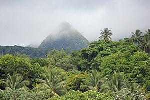
One of the peaks of Mount Pelée, Martinique
Ecoregion NT0179.png
Ecoregion territory (in blue dashed box)
Ecology
Realm Neotropic
Biome Tropical and subtropical moist broadleaf forests
Geography
Area2,072 km2 (800 sq mi)
Country Dominica, Saint Lucia, Saint Vincent and the Grenadines
Coordinates 14°54′N60°58′W / 14.9°N 60.97°W / 14.9; -60.97

The Windward Islands moist forests ecoregion (WWF ID: NT0179) covers forested, high-precipitation areas of the volcanic Windward Islands. The forested areas are mostly at higher elevations in the interior of the islands, surrounded by dry forests, dry shrubland, or mangroves on the flat coastal lowlands. Closed forest of this ecoregion cover the majority of the islands. Species diversity is very high. [1] [2] [3] [4]

Contents

Location and description

The Windward Islands are a volcanic island arc, with mountainous interiors in which steep slopes and difficulty converting the land to agriculture has provided some protection from human settlement and development. Moist forests are found on the islands of Dominica, Martinique, Saint Lucia, Saint Vincent, and Grenada. [2]

Climate

The climate of the ecoregion is Tropical rainforest climate (Köppen climate classification (Af)). This climate is characterized as hot, humid, and having at least 60 mm of precipitation every month. [5] [6] The rainy season occurs in the summer and fall, with precipitation ranging from 10,000 mm/year in the high elevations of Dominica to 3,750 mm/year in the lower elevations of Grenada. [1]

Flora and fauna

70% of the ecoregion is closed, broadleaf evergreen forest. Another 20% is open forest. The characteristics tree species of the mature forests are gommier ( Dacryodes excelsa ), ( Amanoa caribaea ), and trees of genus ( Sloanea ). The mature forests feature widespread epiphytes and lianas, with an understory of Licania ternatensis and Tapura antilliana . Forests that have been cleared for agriculture or timber are typically reforested by Miconia mirabilis and Cecropia schreberiana . [4]

Related Research Articles

<span class="mw-page-title-main">Western Guinean lowland forests</span>

The Western Guinean lowland forests ecoregion is a tropical moist broadleaf forest ecoregion of West Africa. It is centered on Liberia, with portions in surrounding countries. It is the westernmost tropical rainforest in Africa, and has high levels of species endemism, with over 200 species of endemic plants.

<span class="mw-page-title-main">Changbai Mountains mixed forests</span> Ecoregion in China and North Korea

The Changbai Mountains mixed forests ecoregion covers the Changbai Mountains and surrounding foothills in China and North Korea. The region features extensive and naturally preserved deciduous and conifer forests. The region exhibits high biodiversity due to its relative isolation, temperate climate with high rainfall, and centrality to central Chinese, Siberian, and European floral communities. In 1979, a significant portion of the ecoregion was designated the Changbaishan Biosphere Reserve by UNESCO.

<span class="mw-page-title-main">Hainan Island monsoon rain forests</span> Ecoregion in Hainan Island, China

The Hainan Island monsoon rain forests ecoregion covers mountainous interior of Hainan Island in China. The tropical forests receive over 1,000 mm/year of rain, heavily concentrated in the summer rainy season. The island has high levels of biodiversity, with over 4,200 plant species, 630 of which are endemic to the island. The region is under ecological pressure from deforestation for agriculture and timber extraction.

<span class="mw-page-title-main">Northern Khorat Plateau moist deciduous forests</span> Ecoregion in Northern Khorat Plateau

The Northern Khorat Plateau moist deciduous forests ecoregion covers a small area on the border between northeastern Thailand and Laos, in the transition zone between the drier Khorat Plateau to the south and the wetter Annamite Range and Luang Prabang Range mountains to the north. Much of the ecoregion has been converted to agriculture along the floodplain of the middle course of the Mekong River.

<span class="mw-page-title-main">Northern Thailand–Laos moist deciduous forests</span> Ecoregion in Northern Thailand and Laos

The Northern Thailand–Laos moist deciduous forests ecoregion follows the upper course of the Nan River in northern Thailand and the Mekong River in Laos. This area has the highest proportion of tree cover in Thailand, with many forests dominated by Teak. The river valleys have been under pressure from human use: agriculture, teak plantations, and hunting have reduce plant and animal presence.

<span class="mw-page-title-main">Eastern Java–Bali montane rain forests</span> Ecoregion in Eastern Java and Bali

The Eastern Java–Bali montane rain forests ecoregion covers the higher altitude mountain rainforests on the eastern side of the island of Java, and most of the center of the island of Bali in Indonesia. The region has a number of active volcanoes, but is under pressure from growing human populations pushing into higher elevations and more marginal land. With elevations rising from sea level to 3,426 metres (11,240 ft), and precipitation varying between rainforest and drier forest levels, the area has many different forest types – evergreen, deciduous and semi-alpine.

<span class="mw-page-title-main">Eastern Java–Bali rain forests</span> Ecoregion in Eastern Java and Bali

The Eastern Java-Bali rain forests ecoregion covers the lowland areas of the eastern half of the island of Java, and the island of Bali, in Indonesia. This ecoregion is distinct from the Eastern Java-Bali montane rain forests, which exists at higher elevations where mountain forest habitat dominates. Very little of the natural lowland rainforest remains in its pre-human settlement state.

<span class="mw-page-title-main">Western Java rain forests</span> Ecoregion in Java, Indonesia

The Western Java rain forests ecoregion covers the lowland rain forests below 1,000 meters in elevation in the western half of the island of Java in Indonesia. There are a variety of forest types - evergreen, semi-evergreen, moist deciduous, and even some patches of freshwater swamp. The forests have degraded by conversion of the low areas to agriculture, and by logging. National parks protect some of the last remaining untouched rain forest. A number of endangered mammals are found in the ecoregion, including the Javan rhinoceros, the silvery gibbon, and the Javan surili.

<span class="mw-page-title-main">Central American Atlantic moist forests</span>

The Central American Atlantic moist forests ecoregion covers the lowland coastal forests of Honduras, southeast Guatemala, and the eastern forests of Nicaragua. Half of the ecoregion is closed-canopy tropical broadleaf evergreen forest, with tree heights reaching 50 meters. This ecoregion has the largest single fragment of natural forest in Central America, with a size of 14,629 square kilometres (5,648 sq mi). The total area is 89,979 square kilometres (34,741 sq mi).

<span class="mw-page-title-main">Costa Rican seasonal moist forests</span> Ecoregion in Costa Rica and Nicaragua

The Costa Rican seasonal moist forests ecoregion covers the Pacific Slope of the volcanic mountain range of northwestern Costa Rica and the extreme south of Nicaragua. The area has a distinct dry season during which the characteristic deciduous trees drop their leaves. The forests themselves have been highly degraded in the past by human conversion to agriculture and settlement. The Costa Rican capital city of San Jose is in the middle of this ecoregion.

<span class="mw-page-title-main">Isthmian–Pacific moist forests</span>

The Isthmian–Pacific moist forests ecoregion covers the lowland tropical evergreen forests on the Pacific side of the central mountains of southern Costa Rica and western Panama. As the meeting zone between North and South American floral communities, the area is one of very high biodiversity. Much of the rainforest has, however, been cleared for subsistence agriculture and cattle grazing.

<span class="mw-page-title-main">Panamanian dry forests</span>

The Panamanian dry forests ecoregion covers low-lying dry forests around the coast of the Gulf of Panama on the Pacific Ocean side of Panama. It is one of the most heavily degraded ecoregions in Central America, having been heavily converted to agriculture. However, it is also important for its high biodiversity, high rates of endemic species, and its importance as a biological corridor between the moist forests inland and the mangroves on the coast.

<span class="mw-page-title-main">Miskito pine forests</span> Central American ecological zone

The Miskito pine forests ecoregion covers lowland pine forests and savanna along much of the Mosquito Coast in northeastern Nicaragua and southeastern Honduras. Pines are adapted to grow in the poor soil, relative to the surrounding moist forest, and repeated burning have left one species – the Caribbean pine – dominant. Although the ecoregion receives high levels of rain, the hard soils, repeated burning, and exposure to hurricanes have left expanses of 'pine savanna' and seasonal wetlands. The area is thinly settled by humans and there is little crop agriculture.

<span class="mw-page-title-main">Lesser Antilles mangroves</span> Ecoregion in the Lesser Antilles

The Lesser Antilles mangroves ecoregion covers the salt-water habitats along the coasts of the islands on the divide between the Caribbean Sea and the Atlantic Ocean. the included islands stretch from Anguilla in the north to the island of Grenada in the south. The species diversity of these small islands is less than that of the larger islands of the Greater Antilles with to the west, but endemism is high due to the relative isolation of the different islands.

<span class="mw-page-title-main">Cayos Miskitos–San Andrés and Providencia moist forests</span>

The Cayos Miskitos-San Andrés & Providencia moist forests ecoregion cover the forested areas of four islands in the western Caribbean Sea - Cayos Miskitos and the Corn Islands off the east coast of Nicaragua, and San Andrés and Providencia Islands farther east and belonging to the nation of Colombia. The forests on San Adres and Providencia have been heavily degraded by agriculture - coconuts on San Andres, oranges on Providencia. A significant feature of the ecoregion is the surrounding corals reefs, which are large and well preserved. While not technically a part of this terrestrial ecoregion, they are related to the islands.

<span class="mw-page-title-main">Leeward Islands moist forests</span> Forested ecoregion in the Caribbean Sea

The Leeward Islands moist forests ecoregion covers the forested areas of the Leeward Islands on the northeastern edge of the Caribbean Sea, stretching from the Virgin Islands in the west to Guadeloupe to the southeast. The forested areas are typically in the core interior of the islands, and at the higher elevations of the volcanic islands. Non-forested lower elevations in the region receive less rainfall and are typically semi-arid. A notable feature of the ecoregion is its position in the main hurricane track. The frequent damage to trees produces in many places an uneven forest canopy, and an opening of the canopy that allows more pre-climax trees to grow.

<span class="mw-page-title-main">Leeward Islands xeric scrub</span> Xeric shrubland ecoregion of the Leeward Islands

The Leeward Islands xeric scrub ecoregion covers the dry ('xeric'), non-forested areas of the Leeward Islands on the northeastern edge of the Caribbean Sea, stretching from the Virgin Islands in the west to Guadeloupe to the southeast. The non-forested areas are generally low scrub shrub, on the low elevations around the peripheries of the islands. Non-forested lower elevations in the region receive less rainfall and are typically semi-arid. A notable feature of the ecoregion is its position in the main hurricane track. The frequent damage to trees allows more pre-climax shrubs and trees to grow. There are a number of endemic species, as in common with islands.

<span class="mw-page-title-main">Trinidad and Tobago moist forests</span>

The Trinidad and Tobago moist forests ecoregion covers most of Trinidad Island and Tobago Island near the coast of South America where the southeastern Caribbean Sea meets the Atlantic Ocean. Small portions of the islands around river estuaries and coastal lowlands are mangroves or dry forests. Species diversity is very high, in particular for plants and birds. Tobago, being much smaller, has fewer species.

<span class="mw-page-title-main">Windward Islands xeric scrub</span>

The Windward Islands xeric scrub ecoregion covers the relatively small areas of the Windward Islands that receive low levels of precipitation. The dry areas of these islands are the low coastal areas that receive less precipitation. Because the dry scrub land is generally flat, near the coast, and not as obviously in need of conservation as the upland forests of the interior, they are more vulnerable to human settlement and development for agriculture.

<span class="mw-page-title-main">Lesser Antillean dry forests</span>

The Lesser Antillean dry forests ecoregion covers the dry forests of the coastal lowlands of the Lesser Antilles, where the eastern Caribbean Sea meets the Atlantic Ocean. These forests generally form a band around the interior wet forests of higher elevations, and because they are often flat, they are under the most pressure for human settlement and agriculture.

References

  1. 1 2 "Windward Islands moist forests". World Wildlife Federation.
  2. 1 2 "Map of Ecoregions 2017". Resolve, using WWF data.
  3. "Windward Islands moist forests". Digital Observatory for Protected Areas.
  4. 1 2 "Windward Islands moist forests". The Encyclopedia of Earth.
  5. Kottek, M.; Grieser, J.; Beck, C.; Rudolf, B.; Rubel, F. (2006). "World Map of Koppen-Geiger Climate Classification Updated" (PDF). Gebrüder Borntraeger 2006. Retrieved September 14, 2019.
  6. "Dataset - Koppen climate classifications". World Bank. Retrieved September 14, 2019.