Winnebago, Nebraska

Last updated

Winnebago
Nįšoc (Ho-Chunk)
Winnebago, Nebraska Indian Hospital 2.JPG
Indian Health Service hospital in Winnebago, July 2010
Thurston County Nebraska Incorporated and Unincorporated areas Winnebago Highlighted.svg
Location of Winnebago, Nebraska
USA Nebraska relief location map.svg
Red pog.svg
Winnebago
Location within Nebraska
Usa edcp relief location map.png
Red pog.svg
Winnebago
Location within the United States
Coordinates: 42°14′18″N96°28′17″W / 42.23833°N 96.47139°W / 42.23833; -96.47139
Country United States
State Nebraska
County Thurston
Township Winnebago
Area
[1]
  Total0.32 sq mi (0.83 km2)
  Land0.32 sq mi (0.83 km2)
  Water0.00 sq mi (0.00 km2)
Elevation
[2]
1,224 ft (373 m)
Population
 (2020)
  Total916
  Density2,853.58/sq mi (1,100.54/km2)
Time zone UTC-6 (Central (CST))
  Summer (DST) UTC-5 (CDT)
ZIP code
68071
Area code 402
FIPS code 31-53275 [3]
GNIS feature ID2399717 [2]

Winnebago is a village in Thurston County, Nebraska, United States. The population was 916 at the 2020 census. [4]

Contents

History

The first post office at Winnebago was established in 1867. [5] It was named for the federally recognized Winnebago tribe, [6] whose name for themselves (autonym) is Ho-Chunk; they have a reservation in the county. The village is Nįšoc in the Hoocąk language. [7]

Geography

Winnebago is located within the Winnebago Reservation of the Ho-Chunk.

According to the United States Census Bureau, the village has a total area of 0.32 square miles (0.83 km2), all land. [8]

Demographics

Historical population
CensusPop.Note
1910 399
1920 64862.4%
1930 6530.8%
1940 80022.5%
1950 684−14.5%
1960 682−0.3%
1970 675−1.0%
1980 90233.6%
1990 705−21.8%
2000 7688.9%
2010 7740.8%
2020 91618.3%
U.S. Decennial Census [9]

2020 census

As of the census of 2020, [4] the population was 916. The population density was 2,853.6 inhabitants per square mile (1,101.8/km2). There were 309 housing units at an average density of 962.6 per square mile (371.7/km2). The racial makeup of the village was 92.8% Native American, 3.5% White, 0.1% Pacific Islander, 1.2% from other races, and 2.4% from two or more races. Ethnically, the population was 4.6% Hispanic or Latino of any race.

2010 census

As of the census [10] of 2010, there were 774 people, 200 households, and 151 families living in the village. The population density was 3,870.0 inhabitants per square mile (1,494.2/km2). There were 227 housing units at an average density of 1,135.0 per square mile (438.2/km2). The racial makeup of the village was 4.4% White, 0.1% African American, 90.6% Native American, 0.1% from other races, and 4.8% from two or more races. Hispanic or Latino of any race were 4.0% of the population.

There were 200 households, of which 62.0% had children under the age of 18 living with them, 24.0% were married couples living together, 36.5% had a female householder with no husband present, 15.0% had a male householder with no wife present, and 24.5% were non-families. 23.0% of all households were made up of individuals, and 11.5% had someone living alone who was 65 years of age or older. The average household size was 3.84 and the average family size was 4.51.

The median age in the village was 21.4 years. 43.5% of residents were under the age of 18; 10.9% were between the ages of 18 and 24; 20.4% were from 25 to 44; 17.8% were from 45 to 64; and 7.4% were 65 years of age or older. The gender makeup of the village was 48.3% male and 51.7% female.

2000 census

As of the census [3] of 2000, there were 768 people, 211 households, and 166 families living in the village. The population density was 2,704.4 inhabitants per square mile (1,044.2/km2). There were 233 housing units at an average density of 820.5 per square mile (316.8/km2). The racial makeup of the village was 5.47% White, 0.13% African American, 91.93% Native American, 1.95% from other races, and 0.52% from two or more races. Hispanic or Latino of any race were 2.73% of the population.

There were 211 households, out of which 50.7% had children under the age of 18 living with them, 30.8% were married couples living together, 38.9% had a female householder with no husband present, and 20.9% were non-families. 19.0% of all households were made up of individuals, and 10.0% had someone living alone who was 65 years of age or older. The average household size was 3.58 and the average family size was 4.01.

In the village, the population was spread out, with 42.7% under the age of 18, 8.7% from 18 to 24, 28.0% from 25 to 44, 14.1% from 45 to 64, and 6.5% who were 65 years of age or older. The median age was 23 years. For every 100 females, there were 99.0 males. For every 100 females age 18 and over, there were 78.9 males.

As of 2000 the median income for a household in the village was $20,795, and the median income for a family was $21,818. Males had a median income of $18,958 versus $19,643 for females. The per capita income for the village was $6,317. About 43.7% of families and 48.6% of the population were below the poverty line, including 55.6% of those under age 18 and 33.3% of those age 65 or over.

Notable people

See also

Related Research Articles

<span class="mw-page-title-main">Jackson County, Wisconsin</span> County in Wisconsin, United States

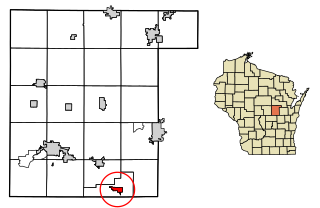
Jackson County is a county located in the U.S. state of Wisconsin. As of the 2020 census, the population was 21,145. Its county seat is Black River Falls. Jackson County was formed from Crawford County in 1853. It was named for President Andrew Jackson.

<span class="mw-page-title-main">Thurston County, Nebraska</span> County in Nebraska, United States

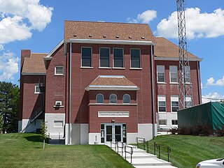
Thurston County is a county in the U.S. state of Nebraska. As of the 2020 United States Census, the population was 6,773. Its county seat is Pender.

<span class="mw-page-title-main">Fort Atkinson, Iowa</span> City in Iowa, United States

Fort Atkinson is a city in Winneshiek County, Iowa, United States. The population was 312 at the time of the 2020 census. It is home to the historic Fort Atkinson State Preserve and hosts a large annual fur-trapper rendezvous each September. Fort Atkinson holds the largest regional hay auction every Wednesday.

<span class="mw-page-title-main">Sloan, Iowa</span> City in Iowa, United States

Sloan is a city in Woodbury County, Iowa, United States. It is part of the Sioux City, IA–NE–SD Metropolitan Statistical Area. The population was 1,042 at the time of the 2020 census.

<span class="mw-page-title-main">Winnebago, Minnesota</span> City in Minnesota, United States

Winnebago is a city in Faribault County, Minnesota, United States. The population was 1,391 at the 2020 census.

<span class="mw-page-title-main">Lake Winnebago, Missouri</span> City in Missouri, United States

Lake Winnebago is a city in Cass County, Missouri, United States. The population was 1,131 at the 2010 census. It is part of the Kansas City metropolitan area.

<span class="mw-page-title-main">Eagle, Nebraska</span> Village in Nebraska, United States

Eagle is a village in southwest Cass County, Nebraska, United States. As of the 2020 census, the village population was 1,065.

<span class="mw-page-title-main">Elmwood, Nebraska</span> Village in Nebraska, United States

Elmwood is a village in southeast Cass County, Nebraska, United States. The population was 654 at the 2020 census.

<span class="mw-page-title-main">Greenwood, Nebraska</span> Village in Nebraska, United States

Greenwood is a village in northwest Cass County, Nebraska, United States. The population was 595 at the 2020 census.

<span class="mw-page-title-main">Manley, Nebraska</span> Village in Nebraska, United States

Manley is a village in Cass County, Nebraska, United States. The population was 167 at the 2020 census.

<span class="mw-page-title-main">Murray, Nebraska</span> Village in Nebraska, United States

Murray is a village in Cass County, Nebraska, United States. The population was 480 at the 2020 census.

<span class="mw-page-title-main">Callaway, Nebraska</span> Village in Nebraska, United States

Callaway is a village in Custer County, Nebraska, United States. The population was 539 at the 2010 census.

<span class="mw-page-title-main">Boys Town, Nebraska</span> Village in Douglas County, Nebraska, United States

Boys Town is a village in Douglas County, Nebraska, United States. The population was 410 at the 2020 census. Boys Town is an enclave and a suburb of Omaha.

<span class="mw-page-title-main">Waterloo, Nebraska</span> Village in Douglas County, Nebraska, United States

Waterloo is a village in Douglas County, Nebraska, United States. The population was 935 at the 2020 census.

<span class="mw-page-title-main">Valparaiso, Nebraska</span> Village in Saunders County, Nebraska, United States

Valparaiso is a village in Saunders County, Nebraska, United States. The population was 595 at the 2020 census.

<span class="mw-page-title-main">Waukechon, Wisconsin</span> Town in Wisconsin, United States

Waukechon is a town in Shawano County, Wisconsin, United States. The population was 928 at the 2000 census. The unincorporated community of Lunds is located in the town. Its Menominee name is Wākecānāpāēw, meaning "crooked beak man", a reference to the Thunderbird Clan of the Ho-Chunk.

<span class="mw-page-title-main">Nekoosa, Wisconsin</span> City in Wisconsin, United States

Nekoosa is a city in Wood County, Wisconsin, United States. Its name derives from the Ho-Chunk word, "Nįįkuusra", "Nakrusa", or "Nįkusara" which translates to "running water". The population was 2,580 at the 2010 census.

<span class="mw-page-title-main">Fremont, Wisconsin</span> Village in Wisconsin, United States

Fremont is a village in Waupaca County, Wisconsin, United States. It is surrounded by Town of Fremont. The population was 679 at the 2010 census. Fremont has been referred to as the "White Bass Capital of the World."

<span class="mw-page-title-main">Neenah, Wisconsin</span> Human settlement in Wisconsin, USA, since 1835

Neenah is a city in Winnebago County, Wisconsin, in the north central United States. It is situated on the banks of Lake Winnebago, Little Lake Butte des Morts, and the Fox River, approximately forty miles (64 km) southwest of Green Bay. Neenah's population was 27,319 at the 2020 census.

<span class="mw-page-title-main">Black River Falls, Wisconsin</span> City in Wisconsin, United States

Black River Falls is a city in and the county seat of Jackson County, Wisconsin, United States. The population was 3,523 at the 2020 census. It is home to the administrative center of the Ho-Chunk Nation.

References

  1. "ArcGIS REST Services Directory". United States Census Bureau. Retrieved September 18, 2022.
  2. 1 2 U.S. Geological Survey Geographic Names Information System: Winnebago, Nebraska
  3. 1 2 "U.S. Census website". United States Census Bureau . Retrieved January 31, 2008.
  4. 1 2 "2020 Decennial Census: Winnebago village, Nebraska". data.census.gov. U.S. Census Bureau. Retrieved July 19, 2022.
  5. "Thurston County". Jim Forte Postal History. Retrieved August 23, 2014.
  6. Fitzpatrick, Lillian L. (1960). Nebraska Place-Names. University of Nebraska Press. p. 140. ISBN   0-8032-5060-6. A 1925 edition is available for download at University of Nebraska—Lincoln Digital Commons.
  7. "Locations". Hoocąk Waaziija Haci Language Division, A Division of The Ho-Chunk Nation. Retrieved April 6, 2014.
  8. "2020 Gazetteer Files". census.gov. U.S. Census Bureau. Retrieved July 19, 2022.
  9. "Census of Population and Housing". Census.gov. Retrieved June 4, 2015.
  10. "U.S. Census website". United States Census Bureau . Retrieved June 24, 2012.