Related Research Articles

Kidsgrove is a town in the borough of Newcastle-under-Lyme, Staffordshire, England, on the Cheshire border. It is part of the Potteries Urban Area, along with Stoke-on-Trent and Newcastle-under-Lyme. It has a population of 26,276. Most of the town is in the Kidsgrove ward, whilst the western part is in Ravenscliffe.

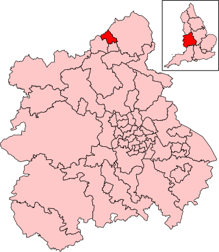
The Borough of Newcastle-under-Lyme is a local government district with borough status in Staffordshire, England.

Staffordshire Moorlands is a constituency represented in the House of Commons of the UK Parliament since 2010 by Karen Bradley, a Conservative who served as Secretary of State for Culture, Media and Sport between 2016 and 2018, before she became Secretary of State for Northern Ireland from 2018 to 2019. As with all constituencies, the constituency elects one Member of Parliament (MP) by the first past the post system of election at least every five years.
Stoke-on-Trent North is a constituency represented in the House of Commons of the UK Parliament by David Williams, a member of the Labour Party.

Chester was a rural district of Cheshire, England, from 1894 to 1974. It was located near the city and county borough of Chester but did not include it. The district saw various boundary changes throughout its life. It included the small civil parish of Chester Castle, an exclave of the rural district within the boundaries of the county borough of Chester.

Chesterton is a former mining village on the edge of Newcastle-under-Lyme, in the Newcastle-under-Lyme district, in Staffordshire, England.
Swinton and Pendlebury was a local government district of the administrative county of Lancashire, England. It was created in 1894 as an urban district and enlarged in 1934, gaining the status of a municipal borough.
Bucklow Rural District was, from 1894 to 1974, a local government district in the north of the administrative county of Cheshire, England. Following the Local Government Act 1972, this rural district was split between the new Greater Manchester boroughs of Trafford and Manchester, and Macclesfield, which was retained in Cheshire.

Newchapel is a village and former civil parish, now in the parish of Kidsgrove, in the Newcastle-under-Lyme district, in the county of Staffordshire, England. In 1951 the parish had a population of 4135.
Wolstanton United Urban District was an urban district in the county of Staffordshire. It was formed in 1904 with the civil parishes of Chesterton, Silverdale and Wolstanton. It was abolished in 1932, when it was absorbed into the Newcastle-under-Lyme Municipal Borough.
Kidsgrove Urban District was an urban district in the county of Staffordshire. It was formed in 1894 with the civil parishes of Hardings Wood, Kidsgrove, Newchapel and Talke. It was abolished in 1974, by virtue of the Local Government Act 1972, when it was absorbed into the Borough of Newcastle-under-Lyme.
Stone Rural District was a rural district in Staffordshire, England. It was created in 1894 and abolished by virtue of the Local Government Act 1972 in 1974. It was originally formed of the civil parishes of Barlaston, Chebsey, Cold Norton, Eccleshall, Milwich, Sandon, Standon, Stone Rural, Swynnerton and Trentham. In 1897 two new civil parishes were added, Fulford and Hilderstone.
Stoke upon Trent Rural District was a rural district in Staffordshire. It was created in 1894 and consisted of two civil parishes, Bagnall and Stoke Rural. Both parishes and the district were abolished in 1922, being absorbed into the county borough of Stoke-on-Trent and the Cheadle Rural District.
Audley Urban District is a former administrative unit in Staffordshire created by the Local Government Act 1894. It contained the civil parish of Audley. In 1932 it was abolished, being absorbed into the Newcastle-under-Lyme Municipal Borough, Newcastle-under-Lyme Rural District and Kidsgrove Urban District.
Smallthorne Urban District was an urban district in Staffordshire, England. It was initially formed of the Smallthorne civil parish. In 1904 the Chell and Milton civil parishes were added. It was abolished in 1922 with the bulk of it becoming part of the county borough of Stoke-on-Trent.

Slough was, from 1863 to 1974, a local government district in southern Buckinghamshire, England. It became an urban district in 1894 and was incorporated as a municipal borough in 1938. It was abolished in 1974 and now forms part of the borough of Slough in Berkshire.

Goldenhill is an area on the northern edge of Stoke-on-Trent, in the Stoke-on-Trent district, in the ceremonial county of Staffordshire, England. It is centred along the High Street, part of the A50 road that runs from south-east to north-west. It is about 1 mile (1.6 km) north of Tunstall and 1.5 miles (2.4 km) south-east of Kidsgrove.
The federation of Stoke-on-Trent was the 1910 amalgamation of the six Staffordshire Potteries towns of Burslem, Tunstall, Stoke-upon-Trent, Hanley, Fenton and Longton into the single county borough of Stoke-on-Trent. The federation was one of the largest mergers of local authorities, involving the greatest number of previously separate urban authorities, to take place in England between the nineteenth century and the 1960s. The 1910 federation was the culmination of a process of urban growth and municipal change that started in the early 19th century.

Chell is a suburb of the city of Stoke-on-Trent in the ceremonial county of Staffordshire, England, that can be subdivided into Little Chell, Great Chell and Chell Heath. It lies on the northern edge of the city, approximately 1-mile (1.6 km) from Tunstall, 2 miles (3.2 km) from Burslem and 3 miles (4.8 km) from the county border with Cheshire. Chell borders Pitts Hill to the west, Tunstall to the south west, Stanfield and Bradeley to the south, with the outlying villages of Packmoor and Brindley Ford to the north and Ball Green to the east. Since 2011 the area has been divided into the electoral wards of Bradeley & Chell Heath, Great Chell & Packmoor and Little Chell & Stanfield.