Related Research Articles

The Great Barrier Reef is the world's largest coral reef system, composed of over 2,900 individual reefs and 900 islands stretching for over 2,300 kilometres (1,400 mi) over an area of approximately 344,400 square kilometres (133,000 sq mi). The reef is located in the Coral Sea, off the coast of Queensland, Australia, separated from the coast by a channel 160 kilometres (100 mi) wide in places and over 61 metres (200 ft) deep. The Great Barrier Reef can be seen from outer space and is the world's biggest single structure made by living organisms. This reef structure is composed of and built by billions of tiny organisms, known as coral polyps. It supports a wide diversity of life and was selected as a World Heritage Site in 1981. CNN labelled it one of the Seven Natural Wonders of the World in 1997. Australian World Heritage places included it in its list in 2007. The Queensland National Trust named it a state icon of Queensland in 2006.

A lagoon is a shallow body of water separated from a larger body of water by a narrow landform, such as reefs, barrier islands, barrier peninsulas, or isthmuses. Lagoons are commonly divided into coastal lagoons and atoll lagoons. They have also been identified as occurring on mixed-sand and gravel coastlines. There is an overlap between bodies of water classified as coastal lagoons and bodies of water classified as estuaries. Lagoons are common coastal features around many parts of the world.

A coral reef is an underwater ecosystem characterized by reef-building corals. Reefs are formed of colonies of coral polyps held together by calcium carbonate. Most coral reefs are built from stony corals, whose polyps cluster in groups.
Landforms are categorized by characteristic physical attributes such as their creating process, shape, elevation, slope, orientation, rock exposure, and soil type.

The Coral Sea is a marginal sea of the South Pacific off the northeast coast of Australia, and classified as an interim Australian bioregion. The Coral Sea extends 2,000 kilometres (1,200 mi) down the Australian northeast coast. Most of it is protected by the French Natural Park of the Coral Sea and the Australian Coral Sea Marine Park. The sea was the location for the Battle of the Coral Sea, a major confrontation during World War II between the navies of the Empire of Japan, and the United States and Australia.

The Burdekin River is a river in North and Far North Queensland, Australia. The river rises on the northern slopes of Boulder Mountain at Valley of Lagoons, part of the western slope of the Seaview Range, and flows into the Coral Sea at Upstart Bay over 200 kilometres (124 mi) to the southeast of the source, with a catchment area of approximately 130,000 square kilometres (50,000 sq mi). The Burdekin River is Australia's largest river by (peak) discharge volume.

A kettle is a depression or hole in an outwash plain formed by retreating glaciers or draining floodwaters. The kettles are formed as a result of blocks of dead ice left behind by retreating glaciers, which become surrounded by sediment deposited by meltwater streams as there is increased friction. The ice becomes buried in the sediment and when the ice melts, a depression is left called a kettle hole, creating a dimpled appearance on the outwash plain. Lakes often fill these kettles; these are called kettle hole lakes. Another source is the sudden drainage of an ice-dammed lake and when the block melts, the hole it leaves behind is a kettle. As the ice melts, ramparts can form around the edge of the kettle hole. The lakes that fill these holes are seldom more than 10 m (33 ft) deep and eventually fill with sediment. In acidic conditions, a kettle bog may form but in alkaline conditions, it will be kettle peatland.

Geologically, a volcanic island is an island of volcanic origin. The term high island can be used to distinguish such islands from low islands, which are formed from sedimentation or the uplifting of coral reefs.
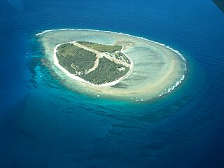
Lady Elliot Island is the southernmost coral cay of the Great Barrier Reef, Australia. The island lies 46 nautical miles north-east of Bundaberg and covers an area of approximately 45 hectares. It is part of the Capricorn and Bunker Group of islands and is owned by the Commonwealth of Australia. The island is home to a small eco resort and an airstrip, which is serviced daily by flights from Bundaberg, Hervey Bay, Brisbane and the Gold Coast.

A blue hole is a large marine cavern or sinkhole, which is open to the surface and has developed in a bank or island composed of a carbonate bedrock. Blue holes typically contain tidally influenced water of fresh, marine, or mixed chemistry. They extend below sea level for most of their depth and may provide access to submerged cave passages. Well-known examples are the Dragon Hole and, in the Caribbean, the Great Blue Hole and Dean's Blue Hole.
Submarine groundwater discharge (SGD) is a hydrological process which commonly occurs in coastal areas. It is described as submarine inflow of fresh-, and brackish groundwater from land into the sea. Submarine groundwater discharge is controlled by several forcing mechanisms, which cause a hydraulic gradient between land and sea. Considering the different regional settings the discharge occurs either as (1) a focused flow along fractures in karst and rocky areas, (2) a dispersed flow in soft sediments, or (3) a recirculation of seawater within marine sediments. Submarine groundwater discharge plays an important role in coastal biogeochemical processes and hydrological cycles such as the formation of offshore plankton blooms, hydrological cycles, and the release of nutrients, trace elements and gases. It affects coastal ecosystems and has been used as a freshwater resource by some local communities for millennia.
The Australian Marine Conservation Society (AMCS) is an Australian environmental not-for-profit organisation. It was founded in 1965 as the Queensland Littoral Society before changing its name to the Australian Littoral Society and then finally in 1995 to its current title. It works on protecting the health and vitality of Australia's coasts and oceans.

The Great Barrier Reef is the world's largest reef systems, stretching along the East coast of Australia from the northern tip down at Cape York to the town of Bundaberg, is composed of roughly 2,900 individual reefs and 940 islands and cays that stretch for 2,300 kilometres (1,616 mi) and cover an area of approximately 344,400 square kilometres (133,000 sq mi). The reef is located in the Coral Sea, off the coast of Queensland in northeast Australia. A large part of the reef is protected by the Great Barrier Reef Marine Park.
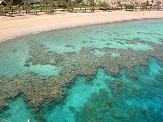
A fringing reef is one of the three main types of coral reef. It is distinguished from the other main types, barrier reefs and atolls, in that it has either an entirely shallow backreef zone (lagoon) or none at all. If a fringing reef grows directly from the shoreline, then the reef flat extends to the beach and there is no backreef. In other cases, fringing reefs may grow hundreds of yards from shore and contain extensive backreef areas within which it contains food and water. Some examples of this are Philippines, Indonesia, Timor-Leste, the western coast of Australia, the Caribbean, East Africa, and Red Sea. Charles Darwin believed that fringing reefs are the first kind of reefs to form around a landmass in a long-term reef growth process. The largest fringing coral reef in the world is the Ningaloo Reef, stretching to around 260 km (160 mi) along the coastline of Western Australia.

A marine habitat is a habitat that supports marine life. Marine life depends in some way on the saltwater that is in the sea. A habitat is an ecological or environmental area inhabited by one or more living species. The marine environment supports many kinds of these habitats.
Subglacial streams are conduits of glacial meltwater that flow at the base of glaciers and ice caps. Meltwater from the glacial surface travels downward throughout the glacier, forming an englacial drainage system consisting of a network of passages that eventually reach the bedrock below, where they form subglacial streams. Subglacial streams form a system of tunnels and interlinked cavities and conduits, with water flowing under extreme pressures from the ice above; as a result, flow direction is determined by the pressure gradient from the ice and the topography of the bed rather than gravity. Subglacial streams form a dynamic system that is responsive to changing conditions, and the system can change significantly in response to seasonal variation in meltwater and temperature. Water from subglacial streams is routed towards the glacial terminus, where it exits the glacier. Discharge from subglacial streams can have a significant impact on local, and in some cases global, environmental and geological conditions. Sediments, nutrients, and organic matter contained in the meltwater can all influence downstream and marine conditions. Climate change may have a significant impact on subglacial stream systems, increasing the volume of meltwater entering subglacial drainage systems and influencing their hydrology.
Wonky may refer to:

Recreational dive sites are specific places that recreational scuba divers go to enjoy the underwater environment or for training purposes. They include technical diving sites beyond the range generally accepted for recreational diving. In this context all diving done for recreational purposes is included. Professional diving tends to be done where the job is, and with the exception of diver training and leading groups of recreational divers, does not generally occur at specific sites chosen for their easy access, pleasant conditions or interesting features.
Mud Hole Spring is an unusual warm-water, submarine discharge of water off the southwestern Gulf Coast of Florida, at 26°15′51″N82°01′02″W, approximately 18.5 kilometres (11.5 mi) south of the Sanibel Island Light and Lee County, Florida. It discharges geothermally warmed and turbid water from the sea floor.

Flinders Reef or Flinders Reefs is an isolated oceanic coral reef in the Coral Sea of the western Pacific Ocean. It lies east of Australia and the extensive Great Barrier Reef. Due to its remote location, it remains poorly studied. However, this isolation has also made it a potential site to mark the beginning of the Anthropocene.
References
- ↑ Horstman, Mark (18 May 2006). "Wonky Holes". Catalyst transcript. Australian Broadcasting Corporation. Retrieved 17 April 2019.
- ↑ Nowak, Rachel (15 November 2002). "'Wonky holes' blamed for coral death". New Scientist.
- ↑ Gagan, Michael K.; Ayliffe, Linda K.; Opdyke, Bradley N.; Hopley, David; Scott-Gagan, Heather; Cowley, Joan (2002). "Coral oxygen isotope evidence for recent groundwater fluxes to the Australian Great Barrier Reef". Geophysical Research Letters. 29 (20): 1982. Bibcode:2002GeoRL..29.1982G. doi: 10.1029/2002GL015336 .
- ↑ "Rocks, Landscapes and Resources of the Wet Tropics", Bernd Lottermoser, Peter W. Witehead, Paul N. Nelson and Robin J. Beaman, Geological Society of Australia, Queensland Division 2008, ISBN 9780975789483.
- ↑ "Camouflage", Joe Haldeman, Ace Books, New York, 2004