Anston is a civil parish in South Yorkshire, England, formally known as North and South Anston. The parish of Anston consists of the settlements of North Anston and South Anston, divided by the Anston Brook.
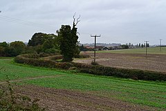
Harthill is a village in the Metropolitan Borough of Rotherham, on the border with Derbyshire. It lies between Killamarsh and Thorpe Salvin, and is located at approximately 53°19′10″N1°15′30″W, at an elevation of around 110 metres above sea level. In the 2001 census, the civil parish of Harthill with Woodall had a population of 1,909, reducing slightly to 1,879 at the 2011 Census.

Wales is a village and a civil parish in the Metropolitan Borough of Rotherham in South Yorkshire, England. Historically part of the West Riding of Yorkshire, it borders to the south Derbyshire and is astride the M1 motorway. The civil parish of Wales, which has a population of 6,455, increasing to 7,069 at the 2011 Census, encompasses the village and neighbouring settlement Kiveton Park.
Kiveton Park, informally Kiveton, or ‘Kivo’, is a village within the Metropolitan Borough of Rotherham, in South Yorkshire, England. Historically a part of the West Riding of Yorkshire, from the Norman conquest to 1868, Kiveton was a hamlet of the parish of Harthill-with-Woodall. It subsequently transferred to the civil parish of Wales which takes its name from the neighbouring village.

Chinley is a rural village in the High Peak Borough of Derbyshire, England, with a population of 2,796 at the 2011 Census. Most of the civil parish is within the Peak District National Park. Historically, before the coming of the railway, the area was economically dominated by agriculture. Nowadays most inhabitants commute out of the village to work; accessible centres of work include Stockport, Sheffield and Manchester.

Ecclesfield is a village and civil parish in the City of Sheffield, South Yorkshire, England, about 4 miles (6 km) north of Sheffield City Centre. Ecclesfield civil parish had a population of 32,073 at the 2011 Census. Ecclesfield wards of the City of Sheffield had a population of 35,994 in 2011. The population of Ecclesfield village stood at 7,163 in the most recent census.

Oughtibridge is a residential village on the northern outskirts of Sheffield within the bounds of Bradfield civil parish. The village stands 5 miles (8 km) north-west of the city centre in the valley of the River Don. The population of the village has increased significantly in recent years due to much private housing development and stood at 3,542 in 2006 over an area of 355 hectares. The population of Oughtibridge increased to 3,584 in 2011.

Mosborough is an electoral ward of the City of Sheffield, England, in the eastern part of the city, on the border with Rotherham. The population in 2011 was 17,097. It is one of the wards that make up the Sheffield South East constituency.

Killamarsh is a town and civil parish in North East Derbyshire, England, bordering Sheffield and South Yorkshire to the north-west. Killamarsh is surrounded by, in a clockwise direction from the north, Rother Valley Country Park, the village of Wales, South Yorkshire, Kiveton, Woodall, Harthill, Barlborough, Spinkhill, Renishaw, Eckington, and the Sheffield suburbs of Oxclose, Halfway and Holbrook.

Hockley Heath is a large village and civil parish in the Arden area mostly within the Metropolitan Borough of Solihull, West Midlands, England, incorporating the hamlet of Nuthurst. The parish, known as Nuthurst cum Hockley Heath, is to the south of the West Midlands conurbation, 12 miles (19 km) southeast of Birmingham 5.5 miles (8.9 km) from Solihull town centre and 12.5 miles (20.1 km) north of Stratford-upon-Avon. The village forms part of the border with Warwickshire and the District of Stratford-on-Avon to the south, with some parts of the village on either side of the border. According to the 2001 census, the parish had a population of 6,771, being measured at the 2011 Census as 2,038.

Tibshelf is a village and civil parish in Derbyshire, England. It is in the Bolsover district of the county. Its population at the 2001 UK census was 3,548, increasing to 3,787 at the 2011 Census. Tibshelf shares its boundaries with the villages of Morton, Pilsley, Newton, Teversal and Hardstoft.

Shepley is a village in the civil parish of Kirkburton, in Kirklees, West Yorkshire, England, and in the Diocese of Wakefield. It lies 8 miles (13 km) south south east of Huddersfield and 6 miles (9.7 km) north west of Penistone.

Woodall services is a motorway service station on the M1 motorway in Rotherham close to Sheffield. It lies between junctions 30 and 31. It was opened in 1968 by Trust House Forte but was renamed Welcome Break after the takeover of the company. It takes its name from the nearby village of Woodall.

Todwick is a village in the Metropolitan Borough of Rotherham in South Yorkshire, England. It has a population of 1,637, reducing marginally to 1,634 at the 2011 Census, and contains a primary school and a nursery, "Todwick Early Years". Todwick also is home to one pub, The Red Lion, and a church. There is a village hall adjacent to the primary school, and this is on the corner of Kiveton Lane and The Pastures. The Pastures has the only shops in the village on it; the Post Office, Doorstop Deli and the Cyprus Gardens pizza house.

The A616 is a road that links Newark-on-Trent, Nottinghamshire, to the M1 motorway at Junction 30, then reappears at Junction 35A and goes on to Huddersfield, West Yorkshire.

The A631 is a road running from Sheffield, South Yorkshire to Louth, Lincolnshire in England. It passes through the counties of South Yorkshire, Nottinghamshire and Lincolnshire. The road has many towns on its route including Rotherham, Maltby, Gainsborough and Market Rasen. It is mostly single road throughout its length but has some stretches of dual carriageway as well. The road is approximately 65 miles (105 km) long.
Upperthorpe and Killamarsh was a railway station in Killamarsh, North East Derbyshire, England which served the village from its opening in 1899 until its closure in 1930. It was situated on the LD&ECR's line into Sheffield between Spinkhill and Woodhouse Mill stations.

Bramley is a village and civil parish of the Metropolitan Borough of Rotherham in South Yorkshire, England.
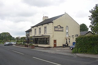
Forton is a village and civil parish in the Wyre district of the English county of Lancashire near the Forest of Bowland. It is near the A6 road, between the city of Lancaster and the town of Garstang. Its population as measured at the 2011 Census is 1,213. It has one school, Forton Primary School, several churches and one pub, the New Holly.
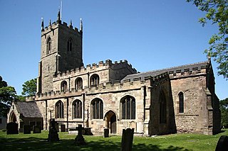
Harthill with Woodall is a civil parish in the Metropolitan Borough of Rotherham, South Yorkshire, England. The parish contains eleven listed buildings that are recorded in the National Heritage List for England. Of these, one is listed at Grade I, the highest of the three grades, one is at Grade II*, the middle grade, and the others are at Grade II, the lowest grade. The parish contains the villages of Harthill and Woodall and the surrounding countryside. The Chesterfield Canal passes through the periphery of the parish, and two bridges crossing it are listed. Most of the other listed buildings are houses and farmhouses, the rest including a church, a former threshing barn, the possible base of a medieval cross, and a schoolhouse.